Wilnis | |
|---|---|
Village | |
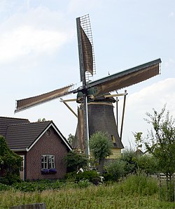 Windmill in Wilnis | |
 Flag  Coat of arms | |
 Wilnis Location in the Netherlands  Wilnis Wilnis (Netherlands) | |
| Coordinates: 52°11′52″N4°54′0″E / 52.19778°N 4.90000°E | |
| Country | Netherlands |
| Province | Utrecht |
| Municipality | De Ronde Venen |
| Area | |
• Total | 20.93 km2 (8.08 sq mi) |
| Elevation | −1.8 m (−5.9 ft) |
| Population (2021) [1] | |
• Total | 6,985 |
| • Density | 333.7/km2 (864.4/sq mi) |
| Time zone | UTC+1 (CET) |
| • Summer (DST) | UTC+2 (CEST) |
| Postal code | 3648 [1] |
| Dialing code | 0297 |
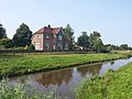
Wilnis is a village in the Dutch province of Utrecht. It is located in the municipality of De Ronde Venen, between Mijdrecht and Vinkeveen. It is about twenty kilometres south of Amsterdam.
Contents
Wilnis was a separate municipality until 1989. [3]