Related Research Articles

West Lothian is one of the 32 council areas of Scotland, bordering the City of Edinburgh council area, Scottish Borders, South Lanarkshire, North Lanarkshire and Falkirk. The modern council area was formed in 1975 when the historic county of West Lothian, also known as Linlithgowshire, was reshaped substantially as part of local government reforms; some areas that had formerly been part of Midlothian were added to a new West Lothian District within the Region of Lothian, whilst some areas in the north-west were transferred to the Falkirk District and areas in the north-east were transferred to the City of Edinburgh District. In 1996 West Lothian became a unitary authority area, using the same name and territory as in 1975.

The M9 is a major motorway in Scotland. It runs from the outskirts of Edinburgh, bypassing the towns of Linlithgow, Falkirk, Grangemouth and Stirling to end at Dunblane.

Broxburn is a town in West Lothian, Scotland. It is 12 miles (19 km) from the West End of Edinburgh, 5 miles (8.0 km) from Edinburgh Airport and 5 miles (8.0 km) to the north of Livingston. Originally a village known as Easter Strathbock in the medieval period, by 1600, the village had become known as Broxburn. The area developed rapidly during the Victorian era as a result of industrialisation related to shale oil extraction. While much of the industry in the area is now diminished, the town has continued to grow following new residential development, resulting in Broxburn forming a conurbation with neighbouring Uphall. It lies just to the south of Winchburgh.

Haymarket railway station is the second largest railway station in Edinburgh, Scotland, after Waverley railway station.
The Edinburgh and Glasgow Railway was authorised by act of Parliament on 4 July 1838. It was opened to passenger traffic on 21 February 1842, between its Glasgow Queen Street railway station and Haymarket railway station in Edinburgh. Construction cost £1,200,000 for 46 miles (74 km). The intermediate stations were at Corstorphine, Gogar, Ratho, Winchburgh, Linlithgow, Polmont, Falkirk, Castlecary, Croy, Kirkintilloch and Bishopbriggs. There was a ticket platform at Cowlairs. The line was extended eastwards from Haymarket to North Bridge in 1846, and a joint station for connection with the North British Railway was opened on what is now Edinburgh Waverley railway station in 1847.
Kirkliston is a village and parish to the west of Edinburgh, Scotland, historically within the county of West Lothian but now within the City of Edinburgh council area limits. It lies on high ground immediately north of a northward loop of the Almond, on the old road between Edinburgh and Linlithgow, having a crossroads with the road from Newbridge to Queensferry and beyond to Fife. The B800 is variously named Path Brae, High Street, Station Road, and Queensferry Road as it passes through the town. The B9080 is named Main Street and Stirling Road as it passes through.

Transport in Scotland is facilitated by road, rail, air and water networks. The Scottish Government and Scottish Parliament has control over most elements of transport policy within Scotland, with the Cabinet Secretary for Transport holding portfolio responsibility within the Scottish Government. Transport Scotland is the Executive Agency responsible for the Scottish transport network.
Dalmeny railway station is a railway station serving the towns of Dalmeny and South Queensferry, about 8 miles (13 km) west of Edinburgh city centre. It is on the Fife Circle Line, located just south of the Forth Bridge.

Edinburgh is a major transport hub in east central Scotland and is at the centre of a multi-modal transport network with road, rail and air communications connecting the city with the rest of Scotland and internationally.

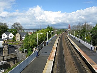
Uphall railway station serves the village of Uphall Station and some areas of Livingston in West Lothian, Scotland. It is located on the North Clyde Line, 12½ miles (20 km) west of Edinburgh.
Princes Street Station was a mainline railway station which stood at the west end of Princes Street, in Edinburgh, Scotland, for almost 100 years. Temporary stations were opened in 1848 and 1870, with construction of the main station commencing in the 1890s. The station was closed completely in 1965 and largely demolished in 1969–70. Only its hotel remains, but it is no longer in railway ownership.

The Airdrie–Bathgate rail link is a completed railway project in central Scotland.
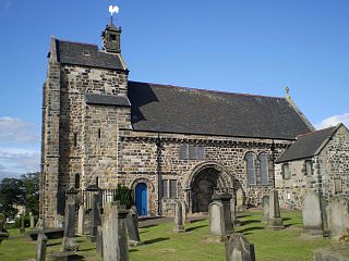
Winchburgh is a village in the council area of West Lothian, Scotland. It is located approximately 10 miles (16 km) west of the city-centre of Edinburgh, 6 miles (9.7 km) east of Linlithgow and 3 miles (4.8 km) northeast of Broxburn.

Linlithgow is a town in West Lothian, Scotland. It was historically West Lothian's county town, reflected in the county's historical name of Linlithgowshire. An ancient town, it lies in the Central Belt on a historic route between Edinburgh and Falkirk beside Linlithgow Loch. The town is situated approximately 20 miles (32 km) west of Edinburgh.

Curriehill is a suburb of Edinburgh, the capital of Scotland. It is north-west of Currie.

Drumshoreland railway station was a railway station in West Lothian, Scotland. It was located on the Edinburgh and Bathgate Railway.
The Edinburgh Glasgow Improvement Programme or EGIP was an initiative funded by Transport Scotland on behalf of the Scottish Government to increase capacity on the main railway line between Edinburgh and Glasgow, with new, longer electric trains running by 2017 and scheduled for full completion in 2019. It was expected to cost £742 million and delivered by Network Rail.
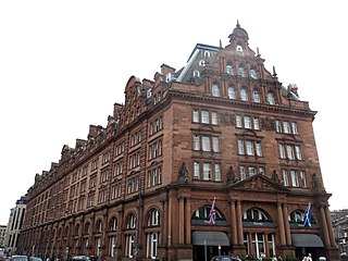
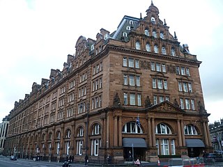
The Caledonian Edinburgh is a five-star hotel in Edinburgh, Scotland. Opened in 1903, it is an example of a British grand railway hotel. Nicknamed "The Caley", it stands at the west end of Princes Street and is a category A listed building.

The Almond Valley Viaduct is a large Victorian railway viaduct on the boundary between West Lothian and Edinburgh in Scotland. The viaduct is 1.5 miles (2.4 km) long and has 36 masonry arches, making it one of the longest viaducts in Scotland. It is Category A Listed.
References
- ↑ Quick, M E (2002). Railway passenger stations in England, Scotland and Wales - a chronology. Richmond: Railway and Canal Historical Society. p. 431. OCLC 931112387.
- 1 2 Johnson, Thomas (12 January 2024). "Systra report promotes benefits of building new West Lothian station". New Civil Engineer. Retrieved 13 January 2024.
- ↑ "Prioritisation of rail projects". Transport Scotland. Archived from the original on 16 February 2021. Retrieved 17 February 2021.
- ↑ Long-awaited Winchburgh railway station would take 1600 cars off clogged Edinburgh roads, Edinburgh Evening News, 14 January 2024