
The Yukon River is a major watercourse of northwestern North America. From its source in British Columbia, Canada, it flows through Canada's territory of Yukon. The lower half of the river continues westward through the U.S. state of Alaska. The river is 3,190 kilometres (1,980 mi) long and empties into the Bering Sea at the Yukon–Kuskokwim Delta. The average flow is 6,400–7,000 m3/s (230,000–250,000 cu ft/s). The total drainage area is 833,000 km2 (321,500 sq mi), of which 323,800 km2 (125,000 sq mi) lies in Canada. The total area is more than 25% larger than Texas or Alberta.

The Back River, formerly Backs River, is the 20th longest Canadian river and is located in the Northwest Territories and Nunavut. It rises at an unnamed lake in the North Slave Region of the Northwest Territories and flows more than 974 km (605 mi) mostly through the Kivalliq Region, Nunavut, to its mouth at the Arctic Ocean in the Kitikmeot Region of Nunavut.

The Mackenzie River is a river in the Canadian boreal forest. It forms, along with the Slave, Peace, and Finlay, the longest river system in Canada, and includes the second largest drainage basin of any North American river after the Mississippi.

The Molalla River is a 51-mile (82 km) tributary of the Willamette River in the northwestern part of Oregon in the United States. Flowing northwest from the Cascade Range through Table Rock Wilderness, it passes the city of Molalla before entering the larger river near Canby. The Molalla is the largest Willamette tributary unblocked by a dam.
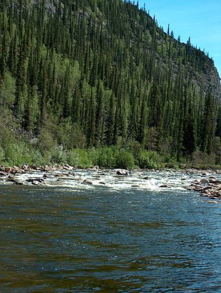
The Charley River is an 88-mile (142 km) tributary of the Yukon River in the U.S. state of Alaska. Flowing generally northeast from the Mertie Mountains in the northeastern part of the state, the river lies entirely within Yukon–Charley Rivers National Preserve. The Charley River enters the larger river downstream and 55 miles (89 km) northwest of Eagle.

The Fortymile River is a 60-mile (97 km) tributary of the Yukon River in the U.S. state of Alaska and the Canadian territory of Yukon. Beginning at the confluence of its north and south forks in the Southeast Fairbanks Census Area, the Fortymile flows generally northeast into Canada to meet the larger river 32 miles (51 km) southeast of Eagle, Alaska.
Whitewater recreation in British Columbia is available in most of the province. Except for north-central and northeast British Columbia, the province is mostly mountainous with many glacial fed rivers draining though steep terrain creating excellent whitewater. Most commercial whitewater operations in British Columbia are rafting outfitters. However the provinces rivers are also well known to be good for whitewater kayaking, whitewater canoeing and river surfing although these activities are often done unguided.

The Chattooga River is the main tributary of the Tugaloo River.
The Pukaskwa River is a river in Thunder Bay District and Algoma District in Northern Ontario, Canada. It is in the Great Lakes Basin and is a tributary of Lake Superior, which it enters at the south end of Pukaskwa National Park. It is a remote, pristine, free-flowing, medium-sized Shield river, with lots of whitewater, best travelled in spring.

The Peel River is a tributary of the Mackenzie River in the Yukon and Northwest Territories in Canada. Its source is in the Ogilvie Mountains in the central Yukon at the confluence of the Ogilvie River and Blackstone River. Its main tributaries are:
The Dumoine River is a river in western Quebec with its source in Machin Lake near La Vérendrye Wildlife Reserve. From Dumoine Lake, the river flows almost due south off the Canadian Shield and empties into the Ottawa River, just west of Rapides-des-Joachims, Quebec, or Rolphton, Ontario. The river is 129 kilometres (80 mi) long and drains a watershed of 5,380 square kilometres (2,080 sq mi). This relatively short river compared to its drainage area indicates that the Dumoine has a strong current and many steep-gradient rapids.

The Kettle is an 83.6-mile-long (134.5 km) tributary of the St. Croix River in eastern Minnesota in the United States. Via the St. Croix River, it is part of the watershed of the Mississippi River. The river's English name is due to the large number of large rounded holes (kettles) in the sandstone in and around the river, carved out by the swirling waters of the river. The river's Dakota name Céġa watpa entered into English via the Anishinaabe people's Akiko-ziibi, both meaning "Kettle River".
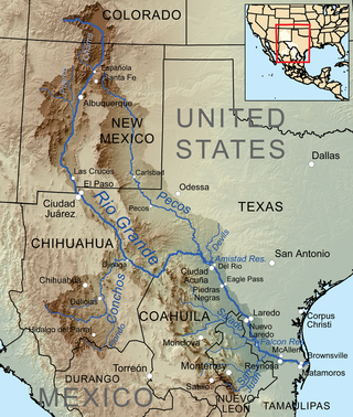
The Devils River in southwestern Texas, part of the Rio Grande drainage basin, has limited areas of whitewater along its length. It begins in northwest Sutton County, at 30°19′40″N100°56′31″W, where six watercourses come together, Dry Devils River, Granger Draw, House Draw, Jackson, Flat Rock Draw, and Rough Canyon. It flows southwest for 94 miles (151 km) through Val Verde County and empties into the northeastern shore of the Amistad Reservoir, an impoundment of the Rio Grande near Del Rio, Texas on the Texas/Mexico border, 29°27′33″N101°3′34″W. The discharge of the Devils River, as measured at IBWC gaging station 08-4494.00 near the river's mouth, averages 362 cubic feet per second (10.3 m3/s), with a maximum of 122,895 cubic feet per second (3,480 m3/s) and a minimum of 54 cubic feet per second (1.53 m3/s). Its drainage basin above that point is 10,259 square kilometres (3,961 sq mi).

The Mulberry River is a 70-mile-long (110 km) tributary of the Arkansas River in northwestern Arkansas in the United States. Via the Arkansas River, it is part of the watershed of the Mississippi River. It has been designated a National Wild and Scenic River. The drainage basin of the Mulberry River has an area of 373 square miles (970 km2) and the annual average mean flow of the river near its mouth is 557 cubic feet per second.
Conewago Creek is a 23.0-mile-long (37.0 km) tributary of the Susquehanna River in Lebanon, Dauphin, and Lancaster counties in Pennsylvania in the United States. The source is at an elevation of 1,100 feet (340 m) at Mount Gretna Heights in Lebanon County. The mouth is the confluence with the Susquehanna River at an elevation of 261 feet (80 m) at the border of Dauphin and Lancaster counties, just south of Three Mile Island in the river and just north of the unincorporated village of Falmouth in Conoy Township, Lancaster County.

Conewago Creek is an 80.2-mile-long (129.1 km) tributary of the Susquehanna River in Adams and York counties in Pennsylvania in the United States, with its watershed also draining a small portion of Carroll County, Maryland. The source is at an elevation of 1,440 feet (440 m), east of Caledonia State Park, in Franklin Township in Adams County. The mouth is the confluence with the Susquehanna River at York Haven in York County at an elevation of 259 feet (79 m).

The Quaboag River is a 25.7-mile-long (41.4 km) river in Massachusetts that heads at Quaboag Pond in Brookfield at an elevation of 594 feet (181 m) above sea level. It flows west to the village of Three Rivers, Massachusetts, at an elevation of 290 feet (88 m).

The Twenty Mile Creek is a minor waterway, located in the Niagara Peninsula, Ontario, Canada. The creek is named for the location of its mouth, twenty miles (32 km) west of the Niagara River along the Lake Ontario shoreline. The Indigenous name for the Twenty Mile Creek was the Kenachdaw, which translates to Lead River.
Big Piney Creek is a river located in Ozark National Forest in the state of Arkansas. It is a tributary of the Arkansas River and therefore part of the Mississippi River watershed. Managed by the United States Forest Service, it flows for 70.8 miles (113.9 km) through Pope, Johnson and Newton counties. The headwaters of the creek are in a rugged, remote area just east of Arkansas Route 21 south of the community of Fallsville and the mouth of the creek empties into Lake Dardanelle on the Arkansas River.

