The Lake District, also known as the Lakes or Lakeland, is a mountainous region in North West England. A popular holiday destination, it is famous for its lakes, forests and mountains, and its associations with William Wordsworth and other Lake Poets and also with Beatrix Potter and John Ruskin. The Lake District National Park was established in 1951 and covers an area of 2,362 square kilometres. It was designated a UNESCO World Heritage Site in 2017.

Bowness-on-Windermere is a town in South Lakeland, Cumbria, England. Due to its position on the banks of Windermere, the town has become a tourist honeypot. Although their mutual growth has caused them to become one large settlement, the town is distinct from the town of Windermere as the two still have distinguishable town centres. Historically part of Westmorland, in 2012, Bowness was one of the official stop off points for the Olympic torch before it made its way to the Olympic Games opening ceremony.
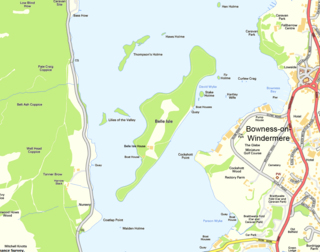
Belle Isle is the largest of 18 islands on Windermere, a mere in the English Lake District, and the only one ever to have been inhabited. It is 1 km in length.

Oxenholme Lake District railway station is a railway station in Oxenholme, near Kendal, in Cumbria, England. The station is situated on the West Coast Main Line and is also the start of the Windermere Branch Line to Windermere. All platforms are electrified; however, platform 3 on the Windermere branch has limited capacity for longer trains. The station serves as a main line connection point for Kendal and Windermere and is managed by Virgin Trains.

The A592 road is a major route running north-south through the English Lake District.

Fell Foot Park is a country park, formerly the grounds of a Victorian house, situated beside Windermere, a lake in Cumbria, England, and in the ownership of the National Trust. It is in the civil parish of Staveley-in-Cartmel in South Lakeland district.

The A591 is a major road in Cumbria, in the north-west of England, which lies almost entirely within the Lake District national park. A 2009 poll by satellite navigation firm Garmin named the stretch of the road between Windermere and Keswick as the most popular road in Britain. The 29.8 mile stretch between Kendal and Keswick was also named the UK's best driving road, according to a specially devised driving ratio formulated by car rental firm Avis.
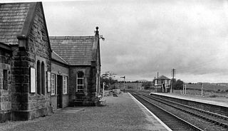
Blencow railway station was situated on the Cockermouth, Keswick and Penrith Railway between Penrith and Cockermouth in Cumbria, England. The station served the villages of Blencow and Newbiggin. The station opened to passenger traffic on 2 January 1865, and closed on 3 March 1952. It reopened temporarily on 2 July 1956 before closing permanently on 6 March 1972.

Scotland is an unincorporated community and census-designated place (CDP) in Taylor Township, Greene County, Indiana, United States. As of the 2010 census it had a population of 134.

Storrs Hall is a hotel on the banks of Windermere in Storrs in the Lake District, Cumbria, England. The hotel, a Grade II* listed Georgian mansion, is also home to the National Trust-owned folly the "Temple" on the end of a stone jetty on Windermere.

Holbeck Ghyll is a restaurant located in Windermere, Cumbria, England. "The late 19th century building was once Lord Lonsdale's hunting lodge and only became a hotel in the 1970s. It won a Michelin star in 1998 but lost it in 2014. It has failed to reclaim the star since. The restaurant is formal and the food a "contemporary take on French and British cuisine".

School Knott is a hill in the Lake District, England, to the east of Windermere town, Cumbria. It is the subject of a chapter of Wainwright's book The Outlying Fells of Lakeland. His recommended route starts at Windermere railway station and includes Grandsire at 818 feet (249 m) and a nameless summit at 806 feet (246 m). The summit is at 760 feet (230 m) and offers a view of four sections of Windermere, the lake. It has a rocky outcrop but no trig point and, as reported by Wainwright, no cairn. Schoolknott Tarn is to the south-east of the summit.

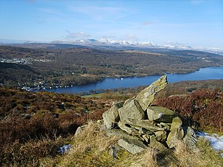
Brant Fell is a hill in the English Lake District, near Bowness-on-Windermere, Cumbria. It is the subject of a chapter of Wainwright's book The Outlying Fells of Lakeland. It reaches 629 feet (192 m). Wainwright's route leaves Bowness along the path of the Dales Way, makes an anticlockwise loop over the viewpoint of Post Knott to the summit, and either returns along the Dales Way or follows a woodland path to Helm Road from where another viewpoint, Biskey Howe, is only a slight detour before continuing down Helm Road to Bowness. He commends its "fine prospect of Windermere".
Staveley Fell is an upland area in the English Lake District, near Staveley-in-Cartmel, Cumbria, east of the southern end of Windermere. It is the subject of a chapter of Wainwright's book The Outlying Fells of Lakeland, but he admits that: "Strictly it has no name, not even locally, being referred to on Ordnance maps as Astley's and Chapel House Plantations, which are new forests severely encroaching upon it". He says it "commands a fine aerial view of the foot of Windermere." The fell reaches 870 feet (270 m) and Wainwright's route is a clockwise loop starting from Staveley-in-Cartmel. Chris Jesty in his revised edition of Wainwright's book provides an alternative route and comments that "There must be many people who, encouraged by the ordnance Survey map, or by the first edition of this book, have ... been turned back by an uncrossable fence."

Winster is a village in the South Lakeland District of Cumbria, in North West England. Historically within the county of Westmorland, it is situated less than two miles east of Windermere, England's largest natural lake. The village is within the Lake District National Park. The village has a pub, the Brown Horse Inn, an 1850s coaching inn.
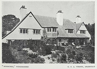
Moor Crag is a Grade I listed house near Bowness-on-Windermere in South Lakeland, Cumbria, England, overlooking Windermere. It lies in the north of the parish of Cartmel Fell. It was designed by C. F. A. Voysey in 1899-1900 as a holiday home for J. W.Buckley of Altrincham.

The SS Raven, sometimes also referred to as the SY Raven, is a steam barge ordered by the Furness Railway for use on the lake of Windermere in the English Lake District, where she has spent her entire working life. She is a member of the National Historic Fleet, and is now preserved. She is the second oldest ship on Lloyd’s Register and the oldest with her original machinery.

The New Hall Inn, also known as the Hole in t'Wall, is the oldest public house in Bowness on Windermere, and is a Grade II listed building.


