Windesheim, Netherlands

Last updated
Windesheim
Windesheim, de Nederlands Hervormde kerk RM41907 IMG 2061 2018-04-07 13.03.jpg
Protestant church in the former brewery
2010-NL-P04-Overijssel-positiekaart-gemnamen.jpg
Red pog.svg
Windesheim
Location in the province of Overijssel in the Netherlands
Netherlands location map.svg
Red pog.svg
Windesheim
Windesheim (Netherlands)
Coordinates: 52°26′50″N6°07′49″E / 52.44731°N 6.13033°E / 52.44731; 6.13033 Coordinates: 52°26′50″N6°07′49″E / 52.44731°N 6.13033°E / 52.44731; 6.13033
Country Netherlands
Province Overijssel
Municipality Zwolle
Area
[1]
  Total0.53 km2 (0.20 sq mi)
Elevation
[2]
2.0 m (6.6 ft)
Population
 (2021) [1]
  Total395
  Density750/km2 (1,900/sq mi)
Postal code
8015 [1]
Dialing code 038

Windesheim is a village in the municipality of Zwolle in the province of Overijssel, Netherlands. The Congregation of Windesheim was located in Windesheim from 1387 until 1577.

Contents

History

The village was first mentioned in 1028 as Wendesheim, and means "settlement of Winid (person)". [3] Windesheim is an esdorp which developed in the Late Middle Ages along the road from Zwolle to Deventer. [4]

In 1387, a monastery by the Brethren of the Common Life was established in the village. [4] The first Dutch translation of the New Testament was made in Windesheim in 1390. [5] The Congregation of Windesheim started to establish sister monasteries, and by 1511 was in charge of 97 monasteries throughout the Holy Roman Empire. During the Reformation, many were demolished or closed down. [6] Around 1570, the monastery in Windesheim was destroyed by the Geuzen. [5] In 1577, all possessions of the congregation were seized by the province of Overijssel. [7]

The Dutch Reformed church was built in the former brewery of the monastery. The building dates from around 1565. By 1633, it was converted into a church by removing the floors. Around 1987, the original windows were restored. Several smaller buildings had survived as well, and were reused as clergy house and farms. [4]

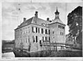
The havezate (manor house) Huis Windesheim was built around 1600. The gardens around the estate were designed by Leonard Springer  [ nl ] in 1813. During World War II, it was expropriated by the German authorities and used as living quarters for German officers. On 20 October 1944, the estate was bombed by the Royal Air Force, [8] and only ruins remain. The gate house and bridge over the moat still exist. The park which measures 570 hectares (1,400 acres) has been restored. [4] [7]

The grist mill Windesheimer Molen was built in 1748, but is a replacement of earlier wind mills. The first mill was built at the site in 1391 by monks of the monastery. In 1952, the wind mill became property of a foundation and was restored to working order. Since 1978, it is owned by the municipality, and is occasionally in service. [9]

Windesheim was home to 232 people in 1840. [7] Between 1866 until 1936, and 1940 until 1941, there was a railway station in Windesheim on the Arnhem–Leeuwarden railway. The building was demolished in 1962. [10]

Windesheim was part of the municipality of Zwollerkerspel until 31 July 1967 when it was merged into Zwolle. [7] In 1977, the city of Zwolle changed the postal stamps of Windesheim to the curious "Dorpstraat Zwolle" (village street Zwolle). Since 1978, Windesheim is no longer a recognised village by the postal authorities. Nevertheless, it is still a separate village and there is a still significant distance to its neighbouring city. [7]

Related Research Articles

Cabauw Village in Utrecht, Netherlands

Cabauw is a village in the Dutch province of Utrecht. It is part of the municipality of Lopik, and lies about 12 km southwest of IJsselstein. Cabauw consists of a small village centre, and a ribbon of farms along the Lopikerwetering canal, between Zevender and Lopik.

Oud-Zuilen Village in Utrecht, Netherlands

Oud-Zuilen is a village in the Dutch province of Utrecht. It is a part of the municipality of Stichtse Vecht, and lies about 4 km northwest of Utrecht. It is in an area called the "Vechtstreek". Zuylen Castle is located in the village.

Vilsteren Village in Overijssel, Netherlands

Vilsteren is a village in the municipality of Ommen in the Dutch province of Overijssel. It is situated just off the left bank of the Vecht in between Dalfsen and Ommen, about 17 kilometres east of the provincial capital of Zwolle.

Nieuwer-Ter-Aa Village in Utrecht, Netherlands

Nieuwer-Ter-Aa is a village in the Dutch province of Utrecht (province). It is a part of the municipality of Stichtse Vecht, and lies about 13 km northwest of Utrecht.

Kockengen Village in Utrecht, Netherlands

Kockengen is a village in the Dutch province of Utrecht. It is a part of the municipality of Stichtse Vecht, and lies about 11 km northeast of Woerden.

Geesteren, Overijssel Village in Overijssel, Netherlands

Geesteren is a village in the eastern Netherlands. It is located in the municipality of Tubbergen, Overijssel about 9 km northeast of Almelo.

Ophemert Village in Gelderland, Netherlands

Ophemert is a village in the Dutch province of Gelderland. It is a part of the municipality of West Betuwe, and lies about 5 km south of Tiel.

Zuilichem Village in Gelderland, Netherlands

Zuilichem is a village in the Dutch province of Gelderland. It is a part of the municipality of Zaltbommel, and lies about 11 km east of Gorinchem. Zuilichem was a separate municipality until 1955, when it was merged with Brakel.

Dreumel Village in Gelderland, Netherlands

Dreumel is a village in the Dutch province of Gelderland. It is a part of the municipality of West Maas en Waal, and lies about 4 km south of Tiel.

Ruinen Former village and municipality in Drenthe, Netherlands

Ruinen is a village in the Dutch province of Drenthe. It is located in the municipality of De Wolden, about 10 km northwest of Hoogeveen. The Dwingelderveld National Park is located near Ruinen.

Noorddijk, Groningen Village in Groningen, Netherlands

Noorddijk is a village in the Dutch province of Groningen. It is located in the municipality of Groningen, about 5 km northeast of the city centre.

Diepenveen Village in Overijssel, Netherlands

Diepenveen is a village in the eastern Netherlands. It is located in the municipality of Deventer, Overijssel, about 4 km north of the city centre.

Wilp Village in Gelderland, Netherlands

Wilp is a village in the Dutch province of Gelderland. It is located in the municipality of Voorst, about 4 km south of Deventer.

Boskamp, Overijssel Village in Overijssel, Netherlands

Boskamp is a village in the Dutch province of Overijssel. It is east of Olst in the municipality of Olst-Wijhe.

Vrouwenparochie Village in Friesland, Netherlands

Vrouwenparochie is a village in Waadhoeke municipality in the province of Friesland, the Netherlands, with a population of around 685 in 2021.

Westergeest Village in Friesland, Netherlands

Westergeest is a village in Noardeast-Fryslân in the province of Friesland, the Netherlands. It has a population of around 621 in January 2017. Before 2019, the village was part of the Kollumerland en Nieuwkruisland municipality.

Easterlittens Village in Friesland, Netherlands

Easterlittens is a village in Leeuwarden in the province of Friesland, the Netherlands. It had a population of around 439 in January 2017.

De Blesse Village in Friesland, Netherlands

De Blesse is a village in Weststellingwerf in the province of Friesland, the Netherlands. It had a population of around 800 in 2017. Its windmill, De Mars, was rebuilt in 1997. Before 1956, the village was called Blesse.

Thesinge Village in Groningen, Netherlands

Thesinge is a village in the municipality of Groningen, in the Dutch province of Groningen.

Loil Village in Gelderland, Netherlands

Loil is a village in the Dutch province of Gelderland. It is a part of the municipality of Montferland. Loil forms a single urban area with Didam and is often referred to as a neighbourhood, however it is an independent village.

References

  1. 1 2 3 "Kerncijfers wijken en buurten 2021". Central Bureau of Statistics. Retrieved 12 April 2022.
  2. "Postcodetool for 8015PA". Actueel Hoogtebestand Nederland (in Dutch). Het Waterschapshuis. Retrieved 12 April 2022.
  3. "Windesheim - (geografische naam)". Etymologiebank (in Dutch). Retrieved 12 April 2022.
  4. 1 2 3 4 Ronald Stenvert & Jan ten Hove (1998). Windesheim (in Dutch). Zwolle: Waanders. ISBN   90 400 9200 1 . Retrieved 12 April 2022.
  5. 1 2 "Ooit was gehucht Windesheim het middelpunt van kerkelijk Europa, maar waarom eigenlijk?". De Stentor (in Dutch). 15 August 2021. Retrieved 12 April 2022.
  6. "Anfänge und Devotio Moderna". Propstei Paring (in German). Retrieved 12 April 2022.
  7. 1 2 3 4 5 "Windesheim". Plaatsengids (in Dutch). Retrieved 12 April 2022.
  8. "Huis Windesheim". Dag van het Kasteel (in Dutch). Retrieved 12 April 2022.
  9. "Windesheimer Molen". Molen database (in Dutch). Retrieved 12 April 2022.
  10. "station Windesheim". Stationsweb (in Dutch). Retrieved 12 April 2022.