Windsor historical landmarks

Last updated

This is a list of 10 historic sites in Windsor, California which have been designated as sites on the Town of Windsor Historic Register by Windsor's town council. [1]

Contents

There are a number of historic places in Windsor. [2]

Windsor has a local historical society, the Windsor Historical Society, which was founded in 1959 and operates a local history museum. [3] The society publishes a local history walking tour guide. [4]

Sonoma County, California designates historic landmarks in unincorporated areas outside towns and cities of the county.

There is one historic site in Windsor which is listed on the National Register of Historic Places: the Cunningham-Hembree Estate, which was listed in 2018. [note 1]

There are two historic sites near Windsor which were designated by Sonoma County and by the National Register of Historic Places: the Mount Weske Stables, just outside the north border of Windsor, and the James H. and Frances E. Laughlin House, south of Windsor.

Map all coordinates using: OpenStreetMap

Windsor historical landmarks

Landmark/
APN [5]
LocationImageDatesNotes
1Masonic Temple [1] :4–5371 Windsor River Road
38°32′51″N122°48′59″W / 38.547423°N 122.816315°W / 38.547423; -122.816315 (Masonic Temple)

38°32′51″N122°48′59″W / 38.54745°N 122.81637°W / 38.54745; -122.81637 (Masonic Temple (newly collected coords))

Masonic Lodge, Windsor, California.jpg 1898 builtFirst constructed in 1898, rebuilt after fire in 1905, then damaged by the earthquake of 1906 and rebuilt! [1] :4–5
2Gutchell Residence [1] :6–8321 Windsor River Road
38°32′51″N122°48′55″W / 38.547481°N 122.815290°W / 38.547481; -122.815290 (Gutchell Residence)
38°32′51″N122°48′55″W / 38.54752°N 122.81526°W / 38.54752; -122.81526 (Gutchell Residence (corrected))
Gutchell Residence, Windsor, California.jpg 1890 built
1975 SCHL-designated
1890 home used as the telephone exchange from at least 1918.
3 Cunningham House
[1] :14–55
9229 Foxwood Drive
38°33′09″N122°48′39″W / 38.552392°N 122.810816°W / 38.552392; -122.810816 (Cunningham House)
Cunningham House, Windsor, California.jpg c.1850 builtThe oldest known structure in Windsor.
4 Hembree House
[1] :9–10
9225 Foxwood Drive
38°33′10″N122°48′38″W / 38.552721°N 122.810604°W / 38.552721; -122.810604 (Hembree House)
Hembree House, Windsor, California.jpg 1931 builtCalled “Mattapan”, an Indian word meaning “I sit down” according to family members.
5Bell Ranch House [1] :16–17294 Windsor River Road

38°32′51″N122°48′52″W / 38.547575°N 122.814506°W / 38.547575; -122.814506 (Bell Ranch House)
38°32′49″N122°48′53″W / 38.54708°N 122.81471°W / 38.54708; -122.81471 (Bell Ranch House (corrected))

Bell Ranch House, Windsor, California.jpg 1860 builtHouse reflecting Greek Revival influence, built in 1860. [4] [1] :16–17
6Heritage Bay Tree
162-041-001 [1] :18–19
Cerrada Court/Foothill Drive
38°33′29″N122°47′35″W / 38.55812°N 122.79302°W / 38.55812; -122.79302 (Heritage Bay Tree)
It may be a large Umbellularia californica (California bay laurel) tree.[ citation needed ]|-
7Shiloh Cemetery
065-260-002 [1] :20–21
7100 Windsor Road
38°31′32″N122°48′54″W / 38.525444°N 122.815073°W / 38.525444; -122.815073 (Shiloh Cemetery)
Shiloh Cemetery Entrance, Windsor, California.jpg Originally a Methodist church site, the first burials are believed to have occurred as early as 1836. The church burned in 1867 and the Shiloh Cemetery Association was formed in 1885.
8David H. DuVander House [1] :22–24295 Windsor River Road
38°32′51″N122°48′54″W / 38.547505°N 122.814937°W / 38.547505; -122.814937 (The David H. DuVander House)

38°32′51″N122°48′54″W / 38.54754°N 122.81492°W / 38.54754; -122.81492 (David H. DuVander House (corrected))

David H. DuVander House, Windsor, California.jpg Late 1880s house believed used in the undertaking business.
9Odd Fellows Hall [1] :25–27
Odd Fellows Osceola No. 215.
337 Windsor River Road
38°32′51″N122°48′48″W / 38.547581°N 122.813433°W / 38.547581; -122.813433 (Odd Fellows Hall)
Windsor International Order of Odd Fellows (IOOF) Hall.jpg When built in 1933, the most substantial building in Windsor. The lodge is upstairs and a grocery store is located downstairs. [1] :25–27
10Old Redwood Highway Palm Trees Old Redwood Highway:
  1. 8635 Old Redwood Hwy, north tree ( 38°32′42″N122°48′14″W / 38.54506°N 122.80400°W / 38.54506; -122.80400 (Palm tree 1) )
  2. 8635 Old Redwood Hwy, south tree ( 38°32′42″N122°48′14″W / 38.54501°N 122.80391°W / 38.54501; -122.80391 (Palm tree 2) )
  3. 15 Bluebird Dr., north tree ( 38°32′41″N122°48′12″W / 38.54470°N 122.80320°W / 38.54470; -122.80320 (Palm tree 3) )
  4. 15 Bluebird Dr., center tree ( 38°32′41″N122°48′11″W / 38.54460°N 122.80302°W / 38.54460; -122.80302 (Palm tree 4) )
  5. 15 Bluebird Dr., south tree ( 38°32′40″N122°48′10″W / 38.54451°N 122.80283°W / 38.54451; -122.80283 (Palm tree 5) )
  6. 8499 Old Redwood Hwy, north tree ( 38°32′39″N122°48′07″W / 38.54403°N 122.80185°W / 38.54403; -122.80185 (Palm tree 6) )
  7. 8499 Old Redwood Hwy, center tree ( 38°32′38″N122°48′06″W / 38.54393°N 122.80166°W / 38.54393; -122.80166 (Palm tree 7) )
  8. 8499 Old Redwood Hwy, south tree ( 38°32′38″N122°48′05″W / 38.54384°N 122.80147°W / 38.54384; -122.80147 (Palm tree 8) )
  9. 8499 Old Redwood Hwy, center (transplanted) [note 2]
  10. 8465 Old Redwood Hwy, farthest north ( 38°32′37″N122°48′05″W / 38.54374°N 122.80127°W / 38.54374; -122.80127 (Palm tree 10) )
  11. 8465 Old Redwood Hwy, center ( 38°32′37″N122°48′04″W / 38.54365°N 122.80108°W / 38.54365; -122.80108 (Palm tree 11) )
  12. 8465 Old Redwood Hwy, farthest south ( 38°32′37″N122°48′03″W / 38.54355°N 122.80089°W / 38.54355; -122.80089 (Palm tree 12) )
  13. 8465 Old Redwood Hwy, frontage btwn Bldgs 200 & 500 ( 38°32′36″N122°48′03″W / 38.54340°N 122.80071°W / 38.54340; -122.80071 (Palm tree 13) )
  14. 8465 Old Redwood Hwy, frontage north of Bldg 200, farthest north ( 38°32′36″N122°48′02″W / 38.54328°N 122.80046°W / 38.54328; -122.80046 (Palm tree 14) )
  15. 8465 Old Redwood Hwy, frontage north of Bldg 200, farthest south ( 38°32′35″N122°48′01″W / 38.54318°N 122.80032°W / 38.54318; -122.80032 (Palm tree 15) )
  16. 8465 Old Redwood Hwy, along Bldg 200 ( 38°32′35″N122°48′01″W / 38.54311°N 122.80016°W / 38.54311; -122.80016 (Palm tree 16) )
  17. 8465 Old Redwood Hwy, south frontage of Bldg 200 ( 38°32′35″N122°48′00″W / 38.54305°N 122.79992°W / 38.54305; -122.79992 (Palm tree 17) ) [1] :29–41
17 palm trees designated as "landmark trees" [1] :29–41

See also

Notes

  1. As determined by comparing locations of all National Register of Historic Places listings in Sonoma County, California to Windsor's boundaries.
  2. Palm tree 9 appears to be gone, per Google Satellite and Streetview and Bing Satellite and Streetside views. Replacements are scattered around the parking area, but none have background matching photo, and there is no palm tree in center.

Related Research Articles

<span class="mw-page-title-main">Sonoma County, California</span> County in California, United States

Sonoma County is located in the U.S. state of California. As of the 2020 United States Census, its population was 488,863. Its seat of government and largest city is Santa Rosa. It is to the north of Marin County and the south of Mendocino County. It is west of Napa and Lake Counties.

<span class="mw-page-title-main">Santa Rosa, California</span> City in California, United States

Santa Rosa is a city in and the county seat of Sonoma County, in the North Bay region of the Bay Area in California. Its population as of the 2020 census was 178,127. It is the largest city in California's Wine Country and Redwood Coast. It is the fifth most populous city in the Bay Area after San Jose, San Francisco, Oakland, and Fremont; and the 25th most populous city in California.

<span class="mw-page-title-main">Windsor, California</span> City in California, United States

Windsor is an incorporated town in Sonoma County, California, United States. The town is 9 miles north of Santa Rosa and 63 miles north of San Francisco. The population was 26,801 as of the 2010 census. Windsor was once home to a waterslide park known as Windsor Waterworks, or as the Doom Flume, from 1980 to 2006. Windsor also has a bowling center which sits right next to the site where the former Windsor Waterworks waterslide park sat until its 2006 closure.

<span class="mw-page-title-main">Palm Beach, Florida</span> Town in the state of Florida, United States

Palm Beach is an incorporated town in Palm Beach County, Florida, United States. Located on a barrier island in east-central Palm Beach County, the town is separated from West Palm Beach and Lake Worth Beach by the Intracoastal Waterway to its west and a small section of the Intracoastal Waterway and South Palm Beach to its south. It is part of the South Florida metropolitan area. As of the 2020 census, Palm Beach had a year-round population of 9,245.

<span class="mw-page-title-main">Old Town San Diego State Historic Park</span> United States historic place

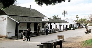
Old Town San Diego State Historic Park, located in the Old Town neighborhood of San Diego, California, is a state protected historical park in San Diego. It commemorates the early days of the City of San Diego and includes many historic buildings from the period 1820 to 1870. The park was established in 1968. In 2005 and 2006, California State Parks listed Old Town San Diego as the most visited state park in California.

<span class="mw-page-title-main">Stagecoach Inn (California)</span> United States historic place

The Stagecoach Inn Museum in Newbury Park, California, originally known as the Grand Union Hotel, was used as a resting area for people who traveled from Los Angeles to Santa Barbara. Besides a hotel and stagecoach stop, it has also been used as a post office, church, restaurant and military school. It is California Historical Landmark No. 659 and is listed in the National Register of Historic Places. It played a major role in the development of the stage line transportation network in California. The hotel was also the first business venture in the Conejo Valley.

<span class="mw-page-title-main">Commemorative plaque</span> Historical marker

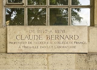
A commemorative plaque, or simply plaque, or in other places referred to as a historical marker, historic marker, or historic plaque, is a plate of metal, ceramic, stone, wood, or other material, typically attached to a wall, stone, or other vertical surface, and bearing text or an image in relief, or both, to commemorate one or more persons, an event, a former use of the place, or some other thing. Many modern plaques and markers are used to associate the location where the plaque or marker is installed with the person, event, or item commemorated as a place worthy of visit. A monumental plaque or tablet commemorating a deceased person or persons, can be a simple form of church monument. Most modern plaques affixed in this way are commemorative of something, but this is not always the case, and there are purely religious plaques, or those signifying ownership or affiliation of some sort. A plaquette is a small plaque, but in English, unlike many European languages, the term is not typically used for outdoor plaques fixed to walls.

<span class="mw-page-title-main">California Historical Landmark</span> Buildings, structures, sites, or places in California determined to have historical significance

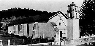
A California Historical Landmark (CHL) is a building, structure, site, or place in the U.S. state of California that has been determined to have statewide historical landmark significance.

<span class="mw-page-title-main">Boca Raton Old City Hall</span> United States historic place

The Boca Raton Old City Hall is a historic site in Boca Raton, Florida, United States. It is located at 71 North Federal Highway. The former city hall now houses the Boca Raton Welcome Center and the Boca Raton History Museum. On October 16, 1980, it was added to the U.S. National Register of Historic Places. The original design was by Addison Mizner. On April 18, 2012, the AIA's Florida Chapter placed it on its list of Florida Architecture: 100 Years. 100 Places as Boca Raton Town Hall.

<span class="mw-page-title-main">Kansas Historical Society</span>

The Kansas Historical Society is the official state historical society of Kansas.

<span class="mw-page-title-main">Free Public Library of Petaluma</span> United States historic place

The Free Public Library of Petaluma is a research library and history museum at 20 Fourth Street in Petaluma, Sonoma County, California, US. Built in 1904 as a Carnegie Free Library, it was designed by Brainerd Jones as his first major commission before the architect gained regional recognition. In the 1970s, it was re-purposed as a research library and historical museum, known as the Petaluma Historical Library and Museum. The building is listed on the National Register of Historic Places.

<span class="mw-page-title-main">San Miguel Chapel Site</span> Historic church in California, United States

The San Miguel Chapel Site is an archeological site in Ventura, California, United States, at the location of the first outpost and center of operations that was established while the first Mission San Buenaventura was being constructed. The San Miguel Chapel was located just outside the southwest corner of the walled garden that was constructed as part of the ultimate layout of the mission complex. The open space park is located at the southwest corner of Thompson Boulevard and Palm Street in downtown Ventura. Interpretative signs and public art have been added to the site, which is protected and managed as a natural environment by the city parks department.

This is a list of Sonoma County Landmarks as designated by the Sonoma County's Landmark Commission.

<span class="mw-page-title-main">City of Ventura Historic Landmarks and Districts</span>

The City of Ventura Historic Landmarks and Districts consist of buildings, sites, and neighborhoods designated by the City of Ventura, California, as historic landmarks and districts.

The Ventura County Historic Landmarks & Points of Interest consist of buildings, sites, and neighborhoods designated by Ventura County Cultural Heritage Board as historic landmarks and points of interest in Ventura County, California. The county board of supervisors created the Cultural Heritage Board in 1966 and in August 1968, two sites were designated: the Faulkner House near Santa Paula; and the Edwards Adobe in Saticoy. The scope was established to include the entire county: both cities and the unincorporated areas. The cities of Fillmore, Oxnard, Port Hueneme, Simi Valley, and Thousand Oaks have the county Cultural Heritage Board advise them and those designations are listed here. The cities of Moorpark, Ojai, Santa Paula, and Ventura established their own separate historic designation systems with the City of Ventura Historic Landmarks and Districts developing into an extensive list. The Port Hueneme Historical Society Museum houses historical artifacts, photographs and information on the history of the Hueneme area. The museum is in the Hueneme Bank Building.

Santa Rosa, California's Cultural Heritage Board recommends sites for Designated Landmark status. The City Council makes the final decisions regarding designations.

The Cunningham-Hembree Estate, in Windsor, California, which includes two houses, was listed on the National Register of Historic Places in 2018.

References

  1. 1 2 3 4 5 6 7 8 9 10 11 12 13 14 15 "Resolution 1343-03: A Resolution of the Town Council of the Town of Windsor Establishing a Town of Windsor Historic Register". Town of Windsor. 2003. Retrieved 2021-01-18.
  2. "Town of Windsor: History" . Retrieved January 15, 2021.
  3. "Windsor Museum". Windsor Historical Society. Retrieved January 15, 2021.
  4. 1 2 "Take a Walk in the Old Downtown" (PDF). Windsor Historical Society. p. 1. Retrieved 2021-01-13.
  5. Assessor's Parcel Number