The San Luis Valley is a region in south-central Colorado with a small portion overlapping into New Mexico. It is the headwaters of the Rio Grande. It contains 6 counties and portions of 3 others. The San Luis Valley was ceded to the United States by Mexico following the Mexican–American War. Hispanic settlers began moving north and settling in the valley after the United States made a treaty with the Utes and established a fort. Prior to the Mexican war the Spanish and Mexican governments had reserved the valley to the Utes, their allies. During the 19th century Anglo settlers settled in the valley and engaged in mining, ranching, and irrigated agriculture. Today the valley has a diverse Anglo and Hispanic population.

The San Juan River is a major tributary of the Colorado River in the southwestern United States, providing the chief drainage for the Four Corners region of Colorado, New Mexico, Utah and Arizona. Originating as snowmelt in the San Juan Mountains of Colorado, it flows 383 miles (616 km) through the deserts of northern New Mexico and southeastern Utah to join the Colorado River at Glen Canyon. The river drains a high, arid region of the Colorado Plateau and along its length it is often the only significant source of fresh water for many miles. The San Juan is also one of the muddiest rivers in North America, carrying an average of 25 million US tons of silt and sediment each year.
U.S. Route 550 (US 550) is a spur of U.S. Highway 50 that runs from Bernalillo, New Mexico to Montrose, Colorado in the western United States. The section from Silverton to Ouray is frequently called the Million Dollar Highway.
The Colorado Trail is a long-distance trail running for 486 miles (782 km) from the mouth of Waterton Canyon southwest of Denver to Durango in Colorado, United States. Its highest point is 13,271 feet (4,045 m) above sea level, and most of the trail is above 10,000 feet (3,000 m). Despite its high elevation, the trail often dips below the alpine timberline to provide refuge from the exposed, storm-prone regions above.

Red Mountain Pass elevation 11,018 ft (3,358 m) is a mountain pass in the San Juan Mountains of western Colorado in the United States.

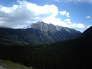
Red Mountain is a set of three peaks in the San Juan Mountains of western Colorado in the United States, about 5 miles south of Ouray. The mountains get their name from the reddish iron ore rocks that cover the surface. Several other peaks in the San Juan Mountains likewise have prominent reddish coloration from iron ore and are also called "Red Mountain".
The San Juan Skyway is an All-American Road and a component in the Colorado Scenic and Historic Byway System. It forms a 233.0-mile (375.0 km) loop in the southwest part of the U.S. state of Colorado traversing the heart of the San Juan Mountains. It roughly parallels the routes of the narrow gauge railways: Rio Grande Southern ; and the unconnected Ouray and Silverton Branches of the Denver & Rio Grande along US 550 with the Silverton Railroad bridging a part of the gap. Its origin can be traced to the Around the Circle Route promoted by the D&RG.

Molas Pass is a high mountain pass in the San Juan Mountains of western Colorado in the United States.
Twilight Peak is the highest summit of the West Needle Mountains range of the San Juan Mountains System in southwestern Colorado.

Cumbres Pass, elevation 10,022 ft (3,055 m), is a mountain pass in the San Juan Mountains in Colorado, United States. The pass is traversed by State Highway 17 and the Cumbres and Toltec Scenic Railroad. The highway has a moderate 5.8% approach on the north side and a gentler, 4% approach on the south side. It is rarely closed in winter and does not normally cause problems for vehicles, since the road is not a major through highway.

The Brazos Mountains is a range in far northern Rio Arriba County, in northern New Mexico in the southwestern United States. The range is part of the southern portion of the San Juan Mountains which are more well known in Colorado. A high crest runs from the border with Colorado for over 20 miles (32 km) in a south-southeasterly direction. The high point of the range at 11,405 feet (3,476 m) is on Grouse Mesa, at the Brazos Benchmark. Two miles (3 km) to the southeast is the more distinctive Brazos Peak, at 11,288 feet.
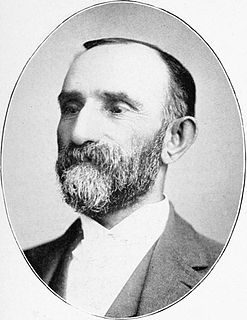
Otto Mears was a famous Colorado railroad builder and entrepreneur who played a major role in the early development of southwestern Colorado.

The Cochetopa Hills are a ridge of uplands on the Continental Divide in Saguache County, southern Colorado, United States.

Conejos Peak is a high and prominent mountain summit in the southern San Juan Mountains of the Rocky Mountains of North America. The 13,179-foot (4,017 m) thirteener is located in the South San Juan Wilderness of Rio Grande National Forest, 19.6 miles (31.6 km) north-northwest of Cumbres Pass in Conejos County, Colorado, United States. The summit of Conejos Peak is the highest point in Conejos County.

The Colorado River is a major river of the western United States and northwest Mexico in North America. Its headwaters are in the Rocky Mountains where La Poudre Pass Lake is its source. Located in north central Colorado it flows southwest through the Colorado Plateau country of western Colorado, southeastern Utah and northwestern Arizona where it flows through the Grand Canyon. It turns south near Las Vegas, Nevada, forming the Arizona–Nevada border in Lake Mead and the Arizona–California border a few miles below Davis Dam between Laughlin, Nevada and Needles, California California before entering Mexico in the Colorado Desert. Most of its waters are diverted into the Imperial Valley of Southern California. In Mexico its course forms the boundary between Sonora and Baja California before entering the Gulf of California. This article describes most of the major features along the river.
Sultan Mountain, elevation 13,373 ft (4,076 m), is a peak of the San Juan Mountains range in San Juan County, southwestern Colorado.
Windy Peak, elevation 11,970 ft (3,648 m), is a summit in the Kenosha Mountains of central Colorado. The peak is south of Bailey in the Lost Creek Wilderness. It is also home to Outdoor Lab for Jefferson County.

Baldy Cinco, elevation 13,379 feet, is a mountain in Hnsdale and Mineral counties in southern Colorado. The mountain, a thirteener, is located on the Continental Divide in the San Juan Mountains. Different areas of the slopes of Baldy Cinco lie in the Rio Grande National Forest, the La Garita Wilderness, and the Gunnison National Forest. The mountain is located just north of Snow Mesa and east northeast of Spring Creek Pass.