
The Saarland is a state of Germany in the west of the country. With an area of 2,570 km2 (990 sq mi) and population of 995,600 in 2015, it is the smallest German state in area apart from the city-states of Berlin, Bremen, and Hamburg, and the smallest in population apart from Bremen. Saarbrücken is the state capital and largest city; other cities include Neunkirchen and Saarlouis. Saarland is mainly surrounded by the department of Moselle in France to the west and south and the neighboring state of Rhineland-Palatinate in Germany to the north and east; it also shares a small border about 8 kilometres long with the canton of Remich in Luxembourg to the northwest.

Noricum is the Latin name for the Celtic kingdom or federation of tribes that included most of modern Austria and part of Slovenia. In the first century AD, it became a province of the Roman Empire. Its borders were the Danube to the north, Raetia and Vindelicia to the west, Pannonia to the east and southeast, and Italia to the south. The kingdom was founded around 400 BC, and had its capital at the royal residence at Virunum on the Magdalensberg.

Saarbrücken is the capital and largest city of the state of Saarland, Germany. Saarbrücken is Saarland's administrative, commercial and cultural centre and is next to the French border.
Sankt Wendel is a Kreis (district) in the north of the Saarland, Germany. Neighboring districts are Trier-Saarburg, Birkenfeld, Kusel, Neunkirchen, Saarlouis, and Merzig-Wadern.

Sankt Wendel[zaŋkt ˈvɛndl̩] is a town in northeastern Saarland. It is situated on the river Blies 36 km northeast of Saarbrücken, the capital of Saarland, and is named after Saint Wendelin of Trier. According to a survey by the German Association for Housing, Town Planning and Land Use Regulation, St. Wendel is known to be one of the wealthiest regions in Germany, behind Starnberg in Bavaria.

Baumholder is a town in the Birkenfeld district in Rhineland-Palatinate, Germany, in the Westrich, an historic region that encompasses areas in both Germany and France. The town of Baumholder is the administrative seat of the like-named Verbandsgemeinde, a state-recognised tourism resort and, according to state planning, a middle centre.

Dillingen is a town in the district of Saarlouis, in Saarland. It has about 20,000 inhabitants and is divided into the three districts Dillingen-city center, Pachten and Diefflen. The city is located on the edge of the Saar-Hunsrück Nature Park at the mouth of the Prims in the Saar and is located about 10 km from the French border. Dillingen is located about 60 km from Luxembourg City and Trier, 50 km from Metz and 30 km from Saarbrücken and is directly adjacent to the urban area of Saarlouis. In terms of population, it is the second largest municipality in the district of Saarlouis. The Dillinger Hütte steelworks is located here.

Blieskastel is a city in the Saarpfalz (Saar-Palatinate) district, in Saarland, Germany which is divided into villages. It is situated on the river Blies, approximately 10 kilometres southwest of Homburg (Saar), 8 km (5 mi) west of Zweibrücken, and 20 km (12 mi) east of Saarbrücken.

Namborn is a municipality in the district of Sankt Wendel, in Saarland, Germany. It is situated approximately 7 km north of Sankt Wendel, and 25 km southwest of Idar-Oberstein. It is approximately 40 km northeast of Saarbrücken on highway B 41 and the Nahe Valley Railway line. The distance to the Bostalsee is about 10 km, and to the county seat St. Wendel about 7 km.

Nohfelden is a municipality in the district of Sankt Wendel, in Saarland, Germany. It is situated approximately 15 kilometres (9.3 mi) north of Sankt Wendel, and 20 kilometres (12 mi) southwest of Idar-Oberstein. It was formed during administrative reform in January 1974 from the merger of 13 previously independent municipalities.

Tholey is a municipality in the district of Sankt Wendel, in Saarland, Germany. It is situated approximately 10 kilometres (6.2 mi) west of Sankt Wendel, and 30 kilometres (19 mi) north of Saarbrücken.
Winterbach may refer to the following places in Germany:

Achtelsbach is an Ortsgemeinde – a municipality belonging to a Verbandsgemeinde, a kind of collective municipality – in the Birkenfeld district in Rhineland-Palatinate, Germany. It belongs to the Verbandsgemeinde of Birkenfeld, whose seat is in the like-named town.
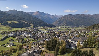
Sankt Michael im Lungau is a market town in the district of Tamsweg in the Austrian state of Salzburg.

The Bavarian State Archaeological Collection in Munich is the central museum of prehistory of the State of Bavaria, considered to be one of the most important archaeological collections and cultural history museums in Germany.
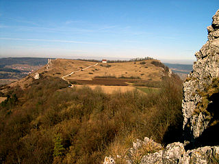
The Ehrenbürg is a double-peaked butte on the edge of the Franconian Jura in Bavaria, Germany. It is in the district of Forchheim in Upper Franconia, in the municipalities of Kirchehrenbach, Leutenbach and Wiesenthau. The north peak is the 513.9 m Walberla, the south peak the 531.7 m Rodenstein. The hill is popularly known as the Walberla.
The Circle of the Rhine or Rhine Circle, sometimes the Bavarian Rheinkreis, was the name given to the territory on the west bank of the Rhine from 1816 to 1837 which was one of 15 administrative districts of the Kingdom of Bavaria. Before the French revolutionary wars (1792) most of the land had belonged to the Electoral Palatinate. At the Congress of Vienna in 1815 it was initially promised to the Empire of Austria after having been under a provisional joint Austro-Bavarian administration since 1814. However, in the Treaty of Munich (1816), Austria relinquished the territory to Bavaria.

The Weiselberg is a hill 569.5 m above sea level (NHN) in the North Palatine Uplands near Oberkirchen in the Saarland county of St. Wendel.

Reimsbach is a village in Germany and part of the Gemeinde Beckingen in the district ("Landkreis") of Merzig-Wadern (Saarland).

Andrea Neumann was a German visual artist and educator. She is one of the most important artists of the Saarland region. She is known for her abstract paintings.


