
The Columbia River Gorge is a canyon of the Columbia River in the Pacific Northwest of the United States. Up to 4,000 feet (1,200 m) deep, the canyon stretches for over eighty miles (130 km) as the river winds westward through the Cascade Range, forming the boundary between the state of Washington to the north and Oregon to the south. Extending roughly from the confluence of the Columbia with the Deschutes River in the east down to the eastern reaches of the Portland metropolitan area, the water gap furnishes the only navigable route through the Cascades and the only water connection between the Columbia Plateau and the Pacific Ocean. It is thus that the routes of Interstate 84, U.S. Route 30, Washington State Route 14, and railroad tracks on both sides run through the gorge.
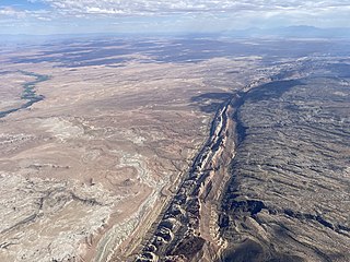
The San Rafael Swell is a large geologic feature located in south-central Utah, United States about 16 miles (26 km) west of Green River. The San Rafael Swell, measuring approximately 75 by 40 miles, consists of a giant dome-shaped anticline of sandstone, shale, and limestone that was pushed up during the Paleocene Laramide Orogeny 60–40 million years ago. Since that time, infrequent but powerful flash floods have eroded the sedimentary rocks into numerous valleys, canyons, gorges, mesas, buttes, and badlands.

Cloudland Canyon State Park is a 3,485 acres (14.10 km2) Georgia state park located near Trenton and Cooper Heights on the western edge of Lookout Mountain. One of the largest and most scenic parks in Georgia, it contains rugged geology, and offers visitors a range of vistas across the deep gorge cut through the mountain by Sitton Gulch Creek, where the elevation varies from 800 to over 1,800 feet. Views of the canyon can be seen from the picnic area parking lot, in addition to additional views located along the rim trail. At the bottom of the gorge, two waterfalls cascade across layers of sandstone and shale, ending in small pools below.

McConnells Mill State Park is a 2,546 acres (1,030 ha) Pennsylvania state park in Perry and Slippery Rock Townships, Lawrence County, Pennsylvania in the United States. The park features a deep scenic gorge with the restored watermill and a covered bridge at the bottom, accessible by a roadway that winds between large, room-sized boulders on the hillside. McConnells Mill State Park is along the Slippery Rock Creek. just southwest of the intersection of US 422 and US 19.

Penn State Erie, The Behrend College, known as Penn State Behrend, is a public satellite campus of Penn State University and is located just outside Erie, Pennsylvania. It is among the largest of Penn State's commonwealth campuses, with about 4,400 students enrolled in Behrend programs on campus and online. The college offers more than 40 undergraduate majors in four academic schools: The Sam and Irene Black School of Business, the School of Engineering, the School of Humanities and Social Sciences, and the School of Science, which includes the Nursing Program. Behrend also offers five master's degrees, as well as a diverse range of continuing education trainings through its Community and Workforce Programs.

Zion Canyon is a deep and narrow gorge in southwestern Utah, United States, carved by the North Fork of the Virgin River. Nearly the entire canyon is located within the western half of Zion National Park.

Fourmile Canyon or Four Mile Canyon is a mountainous canyon in western Boulder County, Colorado that channels a stream known as Fourmile Creek or Four Mile Creek .). The stream rises at 40.048°N 105.550°W on the southern slope of Niwot Mountain, before flowing east and south through the unincorporated communities of Sunset, Wallstreet, Salina and Crisman to the confluence with Boulder Creek at 40.015°N 105.324°W in Boulder Canyon, four miles west of the historic location of the Boulder Railroad Depot.

Pennsylvania Route 290 is a 9.17-mile-long (14.76 km) state highway located in the environs of Erie, Pennsylvania. The western terminus of the route is at Interstate 79 and Pennsylvania Route 5 in the neighborhood of Dock Junction. The eastern terminus is at Interstate 90 and Pennsylvania Route 430 southeast of downtown in Harborcreek Township.

Little Pine State Park is a Pennsylvania state park on 2,158 acres (873 ha) in Cummings Township, Lycoming County, Pennsylvania in the United States. Little Pine State park is along 4.2 miles (6.8 km) of Little Pine Creek, a tributary of Pine Creek, in the midst of the Tiadaghton State Forest. A dam on the creek has created a lake covering 94 acres (38 ha) for fishing, boating, and swimming. The park is on Pennsylvania Route 4001, 4 miles (6.4 km) northeast of the unincorporated village of Waterville or 8 miles (13 km) southwest of the village of English Center. The nearest borough is Jersey Shore, Pennsylvania, about 15 miles (24 km) south at the mouth of Pine Creek on the West Branch Susquehanna River.

Upper Pine Bottom State Park is a 5-acre (2.0 ha) Pennsylvania state park in Lycoming County, Pennsylvania in the United States. The park is in Cummings Township on Pennsylvania Route 44 and is surrounded by the Tiadaghton State Forest. It is on Upper Pine Bottom Run, which gave the park its name and is a tributary of Pine Creek. Upper Pine Bottom State Park is in the Pine Creek Gorge, where the streams have cut through five major rock formations from the Devonian and Carboniferous periods.
Colton Point State Park is a 368-acre (149 ha) Pennsylvania state park in Tioga County, Pennsylvania, in the United States. It is on the west side of the Pine Creek Gorge, also known as the Grand Canyon of Pennsylvania, which is 800 feet (240 m) deep and nearly 4,000 feet (1,200 m) across at this location. The park extends from the creek in the bottom of the gorge up to the rim and across part of the plateau to the west. Colton Point State Park is known for its views of the Pine Creek Gorge, and offers opportunities for picnicking, hiking, fishing and hunting, whitewater boating, and camping. Colton Point is surrounded by Tioga State Forest and its sister park, Leonard Harrison State Park, on the east rim. The park is on a state forest road in Shippen Township 5 miles (8 km) south of U.S. Route 6.

Leonard Harrison State Park is a 585-acre (237 ha) Pennsylvania state park in Tioga County, Pennsylvania, in the United States. It is on the east rim of the Pine Creek Gorge, also known as the Grand Canyon of Pennsylvania, which is 800 feet (240 m) deep and nearly 4,000 feet (1,200 m) across here. It also serves as headquarters for the adjoining Colton Point State Park, its sister park on the west rim of the gorge. Leonard Harrison State Park is known for its views of the Pine Creek Gorge, and offers hiking, fishing and hunting, whitewater boating, and camping. The park is in Shippen and Delmar Townships, 10 miles (16 km) west of Wellsboro at the western terminus of Pennsylvania Route 660.
Lake Erie Watershed is a major drainage catchment in northwestern Pennsylvania, United States, consisting of lands with direct runoff and sub-watersheds with waterways that flow into Lake Erie and Presque Isle Bay from Crawford and Erie counties, as well as from New York. The watershed is part of the Lake Erie Basin.

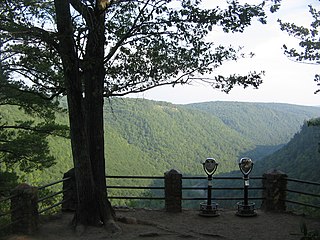
The West Rim Trail is a 30.5 mi (49.1 km) linear hiking trail in Lycoming and Tioga Counties in north central Pennsylvania. The trail mostly follows the edge of Pine Creek Gorge, also known as the Grand Canyon of Pennsylvania, which is up to 1,000 feet (300 m) deep and about 2,000 feet (610 m) wide from rim to rim in the area traversed by the trail. The trail is entirely within Tioga State Forest and is known for its large number of vistas overlooking the gorge, which is a National Natural Landmark and one of the deepest gorges in the eastern United States.

Spearfish Canyon is a deep but narrow gorge carved by Spearfish Creek located in Lawrence County, South Dakota, U.S., just south of Spearfish. The canyon is located within the Black Hills, located on the northern edge of the Black Hills National Forest. The Spearfish Canyon Scenic Byway travels through the Canyon from Spearfish to Cheyenne Crossing along U.S. Route 14A. The highway follows an old railroad grade that was abandoned after massive flooding in 1933.
Fourmile or Four Mile may refer to:

Fourmile Creek is a tributary of Lake Erie in Erie County, Pennsylvania, United States. It is approximately 8 miles (13 km) in length. It has a drainage basin of 11.93 square miles (30.9 km2) and is a part of the Lake Erie Watershed.
The Wintergreen Gorge Bridge is a 1,114-foot (340 m), steel, plate girder bridge that carries Pennsylvania Route 290 and the Bayfront Connector over Fourmile Creek and the Wintergreen Gorge in Harborcreek Township, Erie County in the U.S. state of Pennsylvania. It is both the second-longest and the second-highest bridge in Erie County, with the Interstate 79 bridge in the city of Erie and the Interstate 90 bridge over Sixmile Creek being the longest and the highest, respectively.

The Almy D. Coggleshall Plotter Kill Preserve is a 632-acre (256 ha) nature reserve and hiking area located on Route 159 in the town of Rotterdam, Schenectady County, New York State.

Pine Creek Gorge, sometimes called The Grand Canyon of Pennsylvania, is a 47-mile (76 km) gorge carved into the Allegheny Plateau by Pine Creek in north-central Pennsylvania.
