Wintersmith Park Historic District

Last updated

Wintersmith Park Historic District
WintersmithLake 07Aug2008.jpg
Wintersmith Lake
USA Oklahoma location map.svg
Red pog.svg
Usa edcp location map.svg
Red pog.svg
Location Ada, Oklahoma
Coordinates 34°45′34″N96°39′15″W / 34.75944°N 96.65417°W / 34.75944; -96.65417
Built1933–34
ArchitectCharles E. Kroeger
NRHP reference No. 00000623 [1]
Added to NRHP2000

The Wintersmith Park Historic District, known locally as simply Wintersmith Park, is a historic district located at 18th Street and Scenic Drive in Ada, Oklahoma. The park includes a lake, a lodge, bridges, trails, courts and a public amphitheater. The area is listed in the National Register of Historic Places. The park is named for Frances Wintersmith.

Contents

Location and activities

Wintersmith Park is located on the southeastern edge of Ada. It is south of 18th Street, east of Scenic Drive and west of Country Club Road. The park contains 150 acres (0.61 km2) of land, Wintersmith Lake, a public swimming pool and splash park, a lodge, courts for basketball, softball, volleyball and horseshoes, a 1.5-mile (2.4 km) lighted trail, eight picnic pavilions, a playground, a dog park, and a Kiwanis amusement park as well as bridges, trails and a public amphitheater.

History

Wintersmith Park was a "New Deal" work program, created during the Great Depression by the Civilian Conservation Corps (CCC) to improve communities and provide wages for unemployed people. Work began on the park in 1933 when the young men of camp number 824 arrived in Ada. The men were paid a monthly wage of $30.

A Wintersmith Park Bridge Bridge in Wintersmith Park.jpg
A Wintersmith Park Bridge

The Wintersmith project was unique among New Deal projects as it was the first time the National Park Service (NPS) would be working with the CCC on a project. The NPS usually worked only on the country's national parks.

The combined team would work for more than a year to transform 143 acres (0.58 km2) on Ada's eastern edge. They built a lake, a lodge, bridges, trails, and a public amphitheater.

Public Amphitheater

Built into a naturally occurring slope on the parks south edge, the amphitheater consists of natural stone found in the park and stone quarried from nearby Fittstown, Oklahoma. A crew of stonemasons worked for three months to complete the project.

When completed in 1934, the amphitheater was arguably one of the most distinctive places in Oklahoma. The amphitheatre served as host for many community events, including plays, musicals, public speaking, beauty pageants, talent shows and community sings.

Over the years, however, the amphitheater had slid into disrepair. Frequent use, low level of maintenance and the elements combined to press the amphitheater into a worn out state. The cap stones that serve as seats were often broken, cracked or missing. The risers holding up the seats had suffered significant erosion damage. The barrier walls on the north and sound ends of the amphitheater were compromised or sometimes missing altogether.

Wintersmith Park Amphitheater Wintersmith Park Amphitheater.jpg
Wintersmith Park Amphitheater

Dr. Marvin Kroeker, a longtime Ada resident and East Central University history professor emeritus, hoped to save the amphitheater and bring it back to its former glory. In 2000, Dr. Kroeker took Oklahoma State Historic Preservation Office deputy Melvena Heisch on a tour of the park and the amphitheater. He sought to convince Mrs. Heisch to nominate the amphitheater for designation on the National Register of Historic Places. After the tour, Mrs. Heisch determined the entire Wintersmith area, to be known as the Wintersmith historic district, should be nominated for the Register. The park, including the amphitheater, was accepted for the Register in June 2000.

Following the designation, Dr. Kroeker saw the opportunity to solicit funding from the Oklahoma Centennial Commission for restoration of the amphitheater. The Ada city council voted to designate the amphitheater Ada's Oklahoma Centennial project and made the application for funding from the Centennial Commission. The Centennial Commission accepted the amphitheater project application, and the project was funded with $150,000 of commission grants.

Jones Chapel Schoolhouse Jones Chapel Schoolhouse.jpg
Jones Chapel Schoolhouse

Restoration of the amphitheater has begun. Student and adult volunteers have cleaned up the amphitheater and took down weeds and undergrowth. Dirt contractors have moved the earth to help protect the area from erosion. Concrete workers have poured the new handicap areas at the top and foot of the amphitheater. New “butternut” cap stones were put into place to replace the broken and missing seating.

Upcoming construction plans call for concrete drop off area and parking, concession and ticket buildings, walkways and a stage. Soon after restoration, a special production reintroducing the amphitheater, celebrating Oklahoma's centennial and recognizing the 75th anniversary of America's New Deal is expected. [2]

Jones Chapel Schoolhouse

Jones Chapel Schoolhouse (also known as the "Little Red Schoolhouse") is located in the park off 18th Street. The schoolhouse opened in 1907 west of town. It was moved to the Kerr Lab area in 1976, where it was painted red, and then its current location in Wintersmith Park in 1990. The schoolhouse has many windows, which served both for light and air-conditioning when the building was in use. [3]

Campbell Cabin Campbell Cabin Wintersmith Park.jpg
Campbell Cabin

Campbell Cabin

The Campbell Cabin, located next to the schoolhouse, is another structure with historic significance to the area. The cabin represents Ada's early history in homemaking and demonstrates what it would have been like to live as a pioneer in a log cabin. [4] A sign on the cabin reads "Cecil & Nell Campbell 1609 E 18th ST."

Related Research Articles

<span class="mw-page-title-main">Petit Jean State Park</span> United States historic place

Petit Jean State Park is a 3,471-acre (1,405 ha) park in Conway County, Arkansas managed by the Arkansas Department of Parks and Tourism. It is located on top of Petit Jean Mountain next to the Arkansas River in the area between the Ouachita Mountains and the Ozark Plateaus.

<span class="mw-page-title-main">Bandelier National Monument</span> United States historic place

Bandelier National Monument is a 33,677-acre (136 km2) United States National Monument near Los Alamos in Sandoval and Los Alamos counties, New Mexico. The monument preserves the homes and territory of the Ancestral Puebloans of a later era in the Southwest. Most of the pueblo structures date to two eras, dating between AD 1150 and 1600.

<span class="mw-page-title-main">Starved Rock State Park</span> State park in Illinois, United States

Starved Rock State Park is a state park in the U.S. state of Illinois, characterized by the many canyons within its 2,630 acres (1,064 ha). Located just southeast of the village of Utica, in Deer Park Township, LaSalle County, Illinois, along the south bank of the Illinois River, the park hosts over two million visitors annually, the most for any Illinois state park.

<span class="mw-page-title-main">Lake Murray (Oklahoma)</span> United States historic place

Lake Murray is a 5,700-acre (23 km2) lake in south central Oklahoma, near Ardmore named for Oklahoma Governor William H. Murray. It was created by damming Anadarche and Fourche Maline Creeks. The lake is wholly within Lake Murray State Park, Oklahoma's largest state park, containing over 12,500 acres (51 km2) of relative wilderness. A state-operated lodge and resort is located on the west shore that serves many visitors to the lake, and serves as a base for numerous cabin and campground facilities near the lake.

<span class="mw-page-title-main">Hoeft State Park</span> Park in Michigan, USA

P. H. Hoeft State Park is a public recreation area on the shores of Lake Huron, four miles (6.4 km) northwest of Rogers City on US 23 in Presque Isle County, Michigan. The park was added to the National Register of Historic Places in 2009.

<span class="mw-page-title-main">Bennett Spring State Park</span> State park of Missouri

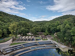
Bennett Spring State Park is a public recreation area located in Bennett Springs, Missouri, twelve miles (19 km) west of Lebanon on Highway 64 in Dallas and Laclede counties. It is centered on the spring that flows into the Niangua River and gives the park its name. The spring averages 100 million gallons of daily flow. The park offers fly fishing, camping, canoeing, hiking, and other activities.

<span class="mw-page-title-main">National Park Service rustic</span> Style of architecture developed in 20th century for the United States National Park Service

National Park Service rustic – sometimes colloquially called Parkitecture – is a style of architecture that developed in the early and middle 20th century in the United States National Park Service (NPS) through its efforts to create buildings that harmonized with the natural environment. Since its founding in 1916, the NPS sought to design and build visitor facilities without visually interrupting the natural or historic surroundings. The early results were characterized by intensive use of hand labor and a rejection of the regularity and symmetry of the industrial world, reflecting connections with the Arts and Crafts movement and American Picturesque architecture.

<span class="mw-page-title-main">White Pines Forest State Park</span> State park in Illinois, US

White Pines Forest State Park, more commonly referred to as White Pines State Park, is an Illinois state park in Ogle County, Illinois. It is located near the communities of Polo, Mount Morris and Oregon. The 385-acre (156 ha) park contains the southernmost remaining stand of native white pine trees in the state of Illinois, and that area, 43 acres (17 ha), was designated an Illinois Nature Preserve in 2001.

<span class="mw-page-title-main">Laurel Hill State Park</span> State park in Pennsylvania, United States

Laurel Hill State Park is a 3,935-acre (1,592 ha) Pennsylvania state park in Jefferson and Middlecreek Townships, Somerset County, Pennsylvania in the United States. Laurel Hill Lake is a 63-acre (25 ha) man-made lake with a dam that was constructed during the Great Depression by the young men of CCC camps NP-5-PA and SP-15-PA. Laurel Hill State Park is 8 miles (13 km) from Interstate 76 just off Pennsylvania Route 31 near Bakersville and on Pennsylvania Route 653 near Trent.

<span class="mw-page-title-main">White Pines State Park Lodge and Cabins</span> United States historic place

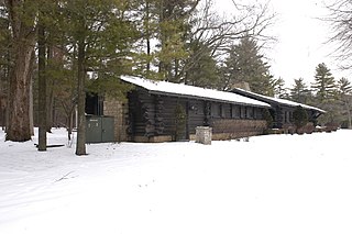
The White Pines State Park Lodge and Cabins are located in rural Ogle County, Illinois near the village of Mount Morris. They were added to the National Register of Historic Places in 1985. The Cabins are one of two Historic Places found in or near Mount Morris, the other is the Samuel M. Hitt House. The Lodge and Cabins are part of a National Register Multiple Property Submission, they were submitted with several other state park lodges, all designed by Joseph F. Booton.

<span class="mw-page-title-main">Bastrop State Park</span> State park and historic site in Texas, United States

Bastrop State Park is a state park in Bastrop County, Texas, United States. The park was established in 1933 and consists of stands of loblolly pines mixed with post oak and junipers.

<span class="mw-page-title-main">Giant City State Park</span> State park in Illinois, USA

Giant City State Park is an Illinois state park on 4,000 acres (1,619 ha) in Jackson and Union Counties, Illinois, United States. Illinois acquired more than 1,100 acres (450 ha) in 1927, and dedicated the park as Giant City State Park. A lodge and visitor center welcome state park guests.

<span class="mw-page-title-main">Backbone State Park</span> State park in Iowa

Backbone State Park is Iowa's oldest state park, dedicated in 1919. Located in the valley of the Maquoketa River, it is approximately three miles (5 km) south of Strawberry Point in Delaware County. It is named for a narrow and steep ridge of bedrock carved by a loop of the Maquoketa River originally known as the Devil's Backbone. The initial 1,200 acres (490 ha) were donated by E.M. Carr of Lamont, Iowa. Backbone Lake Dam, a relatively low dam built by the Civilian Conservation Corps (CCC) in the 1930s, created Backbone Lake. The CCC constructed a majority of trails and buildings which make up the park.

<span class="mw-page-title-main">Copper Falls State Park</span> State park in Ashland County, Wisconsin

Copper Falls State Park is a 3,068-acre (1,242 ha) state park in Wisconsin. The park contains a section of the Bad River and its tributary the Tylers Forks, which flow through a gorge and drop over several waterfalls. Old Copper Culture Indians and later European settlers mined copper in the area. The state park was created in 1929 and amenities were developed by the Civilian Conservation Corps and the Works Progress Administration. In 2005 the park was listed on the National Register of Historic Places as a site with 10 contributing properties.

<span class="mw-page-title-main">Giant Forest Lodge Historic District</span> Historic district in California, United States

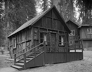
The Giant Forest Lodge Historic District in Sequoia National Park includes the remnants of what was once an extensive National Park Service Rustic style tourist development for park visitors. Also known as Camp Sierra, the district was listed on the National Register of Historic Places in May 1978. Originally situated in the Giant Forest grove of giant sequoias, the district is notable for its nearly total demolition by the National Park Service to eliminate the impact of development on the Big Trees.

<span class="mw-page-title-main">Roaring River State Park</span> State park in Missouri, United States

Roaring River State Park is a public recreation area covering of 4,294 acres (1,738 ha) eight miles (13 km) south of Cassville in Barry County, Missouri. The state park offers trout fishing on the Roaring River, hiking on seven different trails, and the seasonally open Ozark Chinquapin Nature Center.

<span class="mw-page-title-main">Lake Ahquabi State Park</span> State park in Warren County, Iowa

Lake Ahquabi State Park is a state park in Warren County, Iowa, United States, featuring a 115-acre (47 ha) reservoir. Ahquabi means "resting place" in the Fox language. The park is six miles (10 km) south of Indianola and 22 miles (35 km) south of Des Moines. Three sections of the park were listed on the National Register of Historic Places in 1991.

<span class="mw-page-title-main">Wonderland Trail Shelters</span> United States historic place

The Wonderland Trail is an approximately 93-mile (150 km) hiking trail that circumnavigates Mount Rainier in Mount Rainier National Park, Washington, United States. The trail goes over many ridges of Mount Rainier for a cumulative 22,000 feet (6,700 m) of elevation gain. The trail was built in 1915.

<span class="mw-page-title-main">Lacey-Keosauqua State Park</span> State park in Iowa

Lacey-Keosauqua State Park is located southwest of Keosauqua, Iowa, United States. The park is located along the Des Moines River in Van Buren County. First dedicated in 1921, it is the largest state park in size in Iowa. In 1990, three areas were named nationally recognized historic districts and listed on the National Register of Historic Places.

References

  1. "National Register Information System". National Register of Historic Places . National Park Service. January 23, 2007.
  2. "Repairing the damage". Ada Evening News. Retrieved August 7, 2008.
  3. "Explore Ada". Season 3. October 2005.{{cite episode}}: Missing or empty |series= (help)
  4. Tollett, Brenda (June 12, 2008). "Kerr Cabin in good hands". Ada Evening News. Retrieved August 11, 2008.

Swanson, E. (2018, April 28). Dog park build in park. Ada News Paper. Retrieved May 21, 2022, from https://www.theadanews.com/news/local_news/city-building-new-dog-park-at-wintersmith-park/article_b630b84e-6d83-590e-aae2-a064fb164377.html