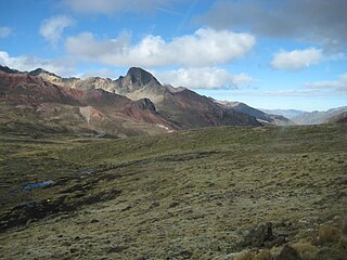
Huarochirí Province or Waruchiri is located in the Lima Region of Peru. Its capital is Matucana. The western section is part of the Lima Metropolitan Area.

The Pariacaca mountain range, also called Huarochirí mountain range lies in the Andes of Peru. It is located in the Junín Region, in the provinces of Jauja and Yauli, and in the Lima Region, in the provinces of Huarochirí and Yauyos. It is part of the Cordillera Central of Peru.
Ch'uspiqucha is a lake in Peru located in the Lima Region, Huarochirí Province, Quinti District. It is situated at a height of about 4,625 metres (15,174 ft), about 1.02 km long and 0.4 km at its widest point. Ch'uspiqucha lies south of the mountain Qullqip'ukru of the Paryaqaqa mountain range and north of the lakes named P'itiqucha, Parya Chaka and Ch'uspi.

Anticona, also called Ticlio, is a mountain in the Andes of Peru, about 5,150 metres (16,896 ft) high. It is located in the Lima Region, Huarochiri Province, Chicla District, and in the Junín Region, Yauli Province, Morococha District. Anticona lies between the Ticlio mountain pass in the southwest and Yanashinga in the northeast, northwest of a lake named Huacracocha.

Putka is a mountain in the Cordillera Central in the Andes of Peru, about 5,100 metres (16,732 ft) high. It is slocated in the Lima Region, Huarochirí Province, Chicla District.

Quri is a mountain in the Cordillera Central in the Andes of Peru, about 5,200 metres (17,060 ft) high. It is situated in the Lima Region, Huarochiri Province, San Mateo District, and in the Junín Region, Yauli Province, Yauli District. Quri lies west of the main branch of the Paryaqaqa or Waruchiri mountain range, southwest of a lake named Wallaqucha (Huallacocha).

Qullqayuq is a mountain in the Cordillera Central in the Andes of Peru, about 5,100 metres (16,732 ft) high. It is situated in the Lima Region, Huarochiri Province, San Mateo District. Qullqayuq lies south of Quri, southwest of the lake named Wallaqucha and northwest of Qarwachuku of the Paryaqaqa or Waruchiri mountain range.

Wararayuq is a 5,354-metre-high (17,566 ft) mountain in the Paryaqaqa mountain range in the Andes of Peru. It is located in the Lima Region, Huarochirí Province, Quinti District. Wararayuq lies northwest of Qullqi P'ukru.

Mulli is a mountain in the Cordillera Central in the Andes of Peru, about 5,000-metre (16,404 ft) high. It lies in the Lima Region, Huarochirí Province, San Damian District. It is situated on a ridge southwest of Utush Mikhunan is situated northwest of Uqhu and Suyruqucha.

Suyruqucha is a mountain in the Paryaqaqa or Waruchiri mountain range in the Andes of Peru, about 5,500 metres (18,045 ft) high. It is located in the Junín Region, Jauja Province, Canchayllo District, in the Yauli Province, Suitucancha District, and in the Lima Region, Huarochiri Province, Quinti District. It lies on the western border of the Nor Yauyos-Cochas Landscape Reserve. It is situated northwest of Qullqip'ukru. Wararayuq lies west of it.

Nina Ukru is a mountain in the Paryaqaqa or Waruchiri mountain range in the Andes of Peru, about 5,400 metres (17,717 ft) high. It is situated in the Lima Region, Huarochirí Province, Quinti District. Nina Ukru lies southwest of Qullqip'ukru and west of Paryaqaqa.

Parqu is a mountain west of the Paryaqaqa or Waruchiri mountain range in the Andes of Peru, about 4,800 m (15,748 ft) high. It is situated in the Lima Region, Huarochirí Province, Quinti District. Parqu lies between the Qarwapampa valley in the west and the Mankaqutu valley in the east, west of the lake named Suyuqqucha.

Parya Chaka is a mountain in the south of the Paryaqaqa or Waruchiri mountain range in the Andes of Peru, about 5,000 m (16,404 ft) high. It is also the name of a lake near the mountain. The mountain is located in the Lima Region, Huarochirí Province, Quinti District, and in the Yauyos Province, Tanta District. It is situated southwest of Paryaqaqa. It is situated within the borders of the Nor Yauyos-Cochas Landscape Reserve.

Nevado Paka is a mountain in the Paryaqaqa mountain range in the Andes of Peru, about 5,510 m (18,080 ft) high. It is situated in the Lima Region, Huarochiri Province, San Mateo District. Paka lies southwest of Wayllakancha, northwest of Pachanqutu and northeast of Tata Qayqu.

Rukutu is a mountain in the Cordillera Central in the Andes of Peru, about 4,800 metres (15,748 ft) high. It is situated in the Lima Region, Huarochirí Province, on the border of the districts of Huarochirí and San Damian. It lies south of Suyruqucha and Suqlla, and northeast of Wamanripa.

Uqsha Wallqa is a mountain in the Paryaqaqa mountain range in the Andes of Peru, about 5,000 metres (16,404 ft) high. It is situated in the Lima Region, Huarochirí Province, on the border of the districts of San Mateo and Quinti. It lies northwest of Paqcha and Wararayuq and southeast of Wamanripa.

Qayqu is a mountain in the Paryaqaqa mountain range in the Andes of Peru, about 5,100 metres (16,732 ft) high. It is situated in the Lima Region, Huarochirí Province, Quinti District. It lies southwest of Qullqi P'ukru.

Kunkus Yantaq is a 5,354-metre-high (17,566 ft) mountain in the Paryaqaqa mountain range in the Andes of Peru. It is located in the Lima Region, Huarochirí Province, San Mateo District. Kunkus Yantaq lies southeast of Qullqayuq.


