The municipalities of Puerto Rico are the second-level administrative divisions in the Commonwealth of Puerto Rico. There are 78 such administrative divisions covering all 78 incorporated towns and cities. Each municipality is led by a mayor and divided into barrios, third-level administrative divisions, though the latter are not vested with any political authority. Every municipality is governed as stated by the Autonomous Municipalities Act of 1991, which establishes that every municipality must have an elected strong mayor with a municipal legislature as the form of government. Each legislature must be unicameral, with the number of members related to adequate representation of the total population of the municipality. In contrast to other jurisdictions, both the mayors and the municipal legislators are elected on the same date and for the same term of four years in office.
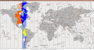
UTC−05:00 is an identifier for a time offset from UTC of −05:00. In North America, it is observed in the Eastern Time Zone during standard time, and in the Central Time Zone during the other eight months. The western Caribbean uses it year round.

UTC−04:00 is an identifier for a time offset from UTC of −04:00.
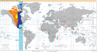
UTC−06:00 is an identifier for a time offset from UTC of −06:00. In North America, it is observed in the Central Time Zone during standard time, and in the Mountain Time Zone during the other eight months. Several Latin American countries and a few other places use it year-round.
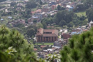
Gorkha District, a part of Gandaki Province, is one of 77 districts of Nepal, and the fourth largest district of the country in terms of area. It is historically linked with the creation of modern Nepal and the name of the legendary Gorkha soldiers. The district, with Gorkha Municipality as its district headquarters, covers an area of 3,610 km2 (1,390 sq mi) and has a population of 252,201, according to the 2021 Nepal census. Gorkha district is the site of the Manakamana Temple, as well as Gorakhnath and Gorakh Kali temples. Several major rivers—including the Chepe, Daraudi, Marsyangdi, Budi Gandaki, and Trishuli—run through the district.

The municipalities are the first-order administrative divisions of North Macedonia.

Albillos is a municipality and town in the province of Burgos, Spain, located about 10 kilometers from the province's capital, Burgos.

Maxilly-sur-Saône is a commune in the Côte-d'Or department in the Bourgogne-Franche-Comté region in eastern France. The inhabitants are called Maximilliens and Maximilliennes.

The 2008 United States presidential election in Ohio took place on November 4, 2008, which was part of the 2008 United States presidential election. Voters chose 20 representatives, or electors to the Electoral College, who voted for president and vice president.

The 2008 United States presidential election in Kentucky took place on November 4, 2008, and was part of the 2008 United States presidential election. Voters chose eight representatives, or electors to the Electoral College, who voted for president and vice president.
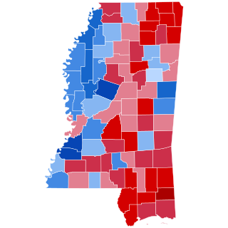
The 2008 United States presidential election in Mississippi took place on November 4, 2008, and was part of the 2008 United States presidential election. Voters chose 6 representatives, or electors to the Electoral College, who voted for president and vice president.

The 2008 United States presidential election in Tennessee was held on November 4, 2008, and was part of the 2008 United States presidential election. Voters chose 11 representatives, or electors, to the Electoral College, who voted for president and vice president.

Cutzamala de Pinzón is a municipality in the Mexican state of Guerrero. The municipal seat lies at Cutzamala de Pinzón. The municipality covers an area of 611.1 km2.
Charaña Municipality is the fifth municipal section of the Pacajes Province in the La Paz Department, Bolivia. Its seat is Charaña.
Luribay Municipality is the first municipal section of the Loayza Province in the La Paz Department, Bolivia. Its seat is Luribay.

Umanata Municipality is the fourth municipal section of the Eliodoro Camacho Province in the La Paz Department in Bolivia. It was created on February 6, 2009. Until then it was one of the cantons of the Viacha Municipality. Its seat is Umanata with 196 inhabitants in 2001.
Nordkreis Weimar is a former Verwaltungsgemeinschaft in the district Weimarer Land in Thuringia, Germany. It was formed on 31 December 2013 by the merger of the former Verwaltungsgemeinschaften Berlstedt and Buttelstedt. The seat of the Verwaltungsgemeinschaft was in Berlstedt. It was disbanded in January 2019.


