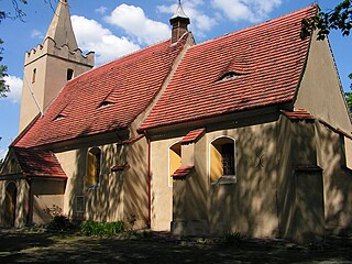
Bardo is a town in Ząbkowice Śląskie County, Lower Silesian Voivodeship, in south-western Poland. It is the seat of the administrative district (gmina) called Gmina Bardo.

Żarów is a town in Świdnica County, Lower Silesian Voivodeship, in south-western Poland. It is the seat of the administrative district (gmina) called Gmina Żarów. The town lies approximately 11 kilometres (7 mi) north-east of Świdnica, and 45 kilometres (28 mi) south-west of the regional capital Wrocław.

Bolków is a town in Jawor County, Lower Silesian Voivodeship, in south-western Poland. It is the seat of the administrative district (gmina) called Gmina Bolków and part of the Neisse-Nysa-Nisa Euroregion.

Kozie Doły is a village in the administrative district of Gmina Kotla, within Głogów County, Lower Silesian Voivodeship, in south-western Poland. Prior to 1945 it was in Germany. It lies approximately 2 kilometres (1 mi) south-west of Kotla, 10 km (6 mi) north-west of Głogów, and 98 km (61 mi) north-west of the regional capital Wrocław.

Proszowa is a village in the administrative district of Gmina Mirsk, within Lwówek Śląski County, Lower Silesian Voivodeship, in south-western Poland, close to the Czech border. Prior to 1945, it was in Germany.

Niwnik is a village in the administrative district of Gmina Oława, within Oława County, Lower Silesian Voivodeship, in south-western Poland. Prior to 1945 it was in Germany.

Ścinawa Polska is a village in the administrative district of Gmina Oława, within Oława County, Lower Silesian Voivodeship, in south-western Poland. Prior to 1945 it was in Germany.

Suchowice is a village in the administrative district of Gmina Borów, within Strzelin County, Lower Silesian Voivodeship, in south-western Poland. Prior to 1945 it was in Germany.

Szczodrowice is a village in the administrative district of Gmina Strzelin, within Strzelin County, Lower Silesian Voivodeship, in south-western Poland. Prior to 1945 it was in Germany.

Piotrowice Świdnickie is a village in the urban-rural Gmina Jaworzyna Śląska, within Świdnica County, Lower Silesian Voivodeship, in south-western Poland. Prior to 1945 it was in Germany.

Siedlimowice is a village in the administrative district of Gmina Żarów, within Świdnica County, Lower Silesian Voivodeship, in south-western Poland. It lies approximately 6 kilometres (4 mi) east of Żarów, 15 kilometres (9 mi) north-east of Świdnica, and 40 kilometres (25 mi) south-west of the regional capital Wrocław.

Szczepankowice is a village in the administrative district of Gmina Kobierzyce, within Wrocław County, Lower Silesian Voivodeship, in south-western Poland. Prior to 1945 it was in Germany.

Sulistrowiczki is a village in the administrative district of Gmina Sobótka, within Wrocław County, Lower Silesian Voivodeship, in south-western Poland.

Polakowice is a village in the administrative district of Gmina Żórawina, within Wrocław County, Lower Silesian Voivodeship, in south-western Poland. Prior to 1945 it was in Germany.

Przecławice is a village in the administrative district of Gmina Żórawina, within Wrocław County, Lower Silesian Voivodeship, in south-western Poland. Prior to 1945 it was in Germany. It lies approximately 9 kilometres (6 mi) south-west of Żórawina and 23 km (14 mi) south of the regional capital Wrocław.

Racławice Małe is a village in the administrative district of Gmina Żórawina, within Wrocław County, Lower Silesian Voivodeship, in south-western Poland. Prior to 1945 it was in Germany.

Węgry is a village in the administrative district of Gmina Żórawina, within Wrocław County, Lower Silesian Voivodeship, in south-western Poland. Prior to 1945 it was in Germany.

Cienkowice is a village in the administrative district of Gmina Ciepłowody, within Ząbkowice Śląskie County, Lower Silesian Voivodeship, in south-western Poland.

Starczów is a village in the administrative district of Gmina Kamieniec Ząbkowicki, within Ząbkowice Śląskie County, Lower Silesian Voivodeship, in south-western Poland. Prior to 1945 it was in Germany.

Przedborowa is a village in the administrative district of Gmina Stoszowice, within Ząbkowice Śląskie County, Lower Silesian Voivodeship, in south-western Poland. Prior to 1945 it was in Germany.


