
Sillim Station is a station on Seoul Subway Line 2. It is located in Sillim-dong, Gwanak-gu, Seoul.
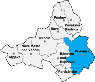
Nevidzany is a village and municipality in Prievidza District in the Trenčín Region of western Slovakia.

The Qadis District is located in the southern part of Badghis province, Afghanistan, between the districts Jawand in the East, Qala i Naw in the west, Muqur and Murghab in the North. In the South is the Herat province. The capital is Qadis.

The Judicial Arrondissement of Eupen is a judicial arrondissement located in the Walloon Province of Liège, in Belgium. It comprises the 9 municipalities of the German-speaking Community. It is not an administrative arrondissement. All of its municipalities are a part of the Administrative Arrondissement of Verviers, which is divided into two judicial arrondissements.
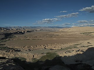
Zanda County is a county in the Ngari Prefecture to the extreme west of the Tibet Autonomous Region of China.

Verin Shengavit is a part of Shengavit District in Yerevan, Armenia.
Dębina is a village in the administrative district of Gmina Uchanie, within Hrubieszów County, Lublin Voivodeship, in eastern Poland.
Brzozowy Borek is a village in the administrative district of Gmina Dąbrowa Białostocka, within Sokółka County, Podlaskie Voivodeship, in north-eastern Poland.
Kierkielewszczyzna is a settlement in the administrative district of Gmina Kuźnica, within Sokółka County, Podlaskie Voivodeship, in north-eastern Poland, close to the border with Belarus.

Rędziny is a village in the administrative district of Gmina Żytno, within Radomsko County, Łódź Voivodeship, in central Poland. It lies approximately 5 kilometres (3 mi) north of Żytno, 17 km (11 mi) south-east of Radomsko, and 91 km (57 mi) south of the regional capital Łódź.
Wolica is a village in the administrative district of Gmina Kozłów, within Miechów County, Lesser Poland Voivodeship, in southern Poland. It lies approximately 5 kilometres (3 mi) east of Kozłów, 15 km (9 mi) north of Miechów, and 49 km (30 mi) north of the regional capital Kraków.
Wojciechówka is a village in the administrative district of Gmina Tyszowce, within Tomaszów Lubelski County, Lublin Voivodeship, in eastern Poland.
Jachimowice is a village in the administrative district of Gmina Samborzec, within Sandomierz County, Świętokrzyskie Voivodeship, in south-central Poland. It lies approximately 9 kilometres (6 mi) west of Samborzec, 16 km (10 mi) south-west of Sandomierz, and 72 km (45 mi) south-east of the regional capital Kielce.
Przyszów is a village in the administrative district of Gmina Bojanów, within Stalowa Wola County, Subcarpathian Voivodeship, in south-eastern Poland. It lies approximately 10 kilometres (6 mi) north of Bojanów, 12 km (7 mi) south of Stalowa Wola, and 50 km (31 mi) north of the regional capital Rzeszów.

The Pasteur Institute of Lille is a research centre and member of the Pasteur Institute network. It includes 14 research units and 1,150 employees including 626 researchers located in Lille, France. There are also 300 employees located outside the Pasteur site. Its revenues are above €70 million. Several neuroscience start-up companies have emerged from the Pasteur Institute of Lille.
Łutowiec is a village in the administrative district of Gmina Niegowa, within Myszków County, Silesian Voivodeship, in southern Poland. It lies approximately 4 kilometres (2 mi) south-west of Niegowa, 11 km (7 mi) north-east of Myszków, and 53 km (33 mi) north-east of the regional capital Katowice.

Roseray is a hamlet in Saskatchewan.
Lepiku is a village in Muhu Parish, Saare County in western Estonia.
Kärevere is a village in Laeva Parish, Tartu County in eastern Estonia.

Gopikandar is a community development block that forms an administrative division in Dumka district, Jharkhand state, India. It is located 35 km from Dumka, the district headquarters.


