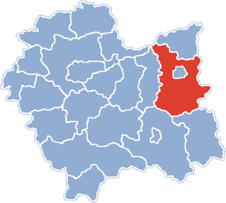
Ryglice is a town in Lesser Poland Voivodeship, Tarnów County, the seat of the urban-rural gmina Ryglice. It is located about 30 kilometres from Tarnów, near the town of Tuchów, and had town privileges in 1824-1934, and from 2001. Between 1975 and 1998, Ryglice administratively belonged to Tarnów Voivodeship. On 30 June 2007, the population of the town was 2,811.
Gmina Skrzyszów is a rural gmina in Tarnów County, Lesser Poland Voivodeship, in southern Poland. Its seat is the village of Skrzyszów, which lies approximately 7 kilometres (4 mi) south-east of Tarnów and 81 km (50 mi) east of the regional capital Kraków.
Gmina Szerzyny is a rural gmina in Tarnów County, Lesser Poland Voivodeship, in southern Poland. Its seat is the village of Szerzyny, which lies approximately 31 kilometres (19 mi) south-east of Tarnów and 99 km (62 mi) east of the regional capital Kraków.

Bruśnik is a village in the administrative district of Gmina Ciężkowice, within Tarnów County, Lesser Poland Voivodeship, in southern Poland. It lies approximately 7 kilometres (4 mi) south-west of Ciężkowice, 32 km (20 mi) south of Tarnów, and 79 km (49 mi) south-east of the regional capital Kraków.

Kąśna Dolna is a village in the administrative district of Gmina Ciężkowice, within Tarnów County, Lesser Poland Voivodeship, in southern Poland. It lies approximately 6 kilometres (4 mi) south-west of Ciężkowice, 31 km (19 mi) south of Tarnów, and 78 km (48 mi) south-east of the regional capital Kraków.
Dąbrówka Szczepanowska is a village in the administrative district of Gmina Pleśna, within Tarnów County, Lesser Poland Voivodeship, in southern Poland. It lies approximately 17 kilometres (11 mi) south-west of Tarnów and 69 km (43 mi) east of the regional capital Kraków.
Łowczówek is a village in the administrative district of Gmina Pleśna, within Tarnów County, Lesser Poland Voivodeship, in southern Poland. It lies approximately 13 kilometres (8 mi) south of Tarnów and 77 km (48 mi) east of the regional capital Kraków.
Bistuszowa is a village in the administrative district of Gmina Ryglice, within Tarnów County, Lesser Poland Voivodeship, in southern Poland. It lies approximately four miles west of Ryglice, 18 km (11 mi) south of Tarnów, and 85 km (53 mi) east of the regional capital Kraków.
Kowalowa is a village in the administrative district of Gmina Ryglice, within Tarnów County, Lesser Poland Voivodeship, in southern Poland. It lies approximately 6 kilometres (4 mi) east of Ryglice, 24 km (15 mi) south-east of Tarnów, and 93 km (58 mi) east of the regional capital Kraków.
Lubcza is a village in the administrative district of Gmina Ryglice, within Tarnów County, Lesser Poland Voivodeship, in southern Poland. It lies approximately 10 kilometres (6 mi) east of Ryglice, 25 km (16 mi) south-east of Tarnów, and 97 km (60 mi) east of the regional capital Kraków.
Uniszowa is a village in the administrative district of Gmina Ryglice, within Tarnów County, Lesser Poland Voivodeship, in southern Poland. It lies approximately 2 kilometres (1 mi) west of Ryglice, 19 km (12 mi) south-east of Tarnów, and 87 km (54 mi) east of the regional capital Kraków.
Zalasowa is a village in the administrative district of Gmina Ryglice, within Tarnów County, Lesser Poland Voivodeship, in southern Poland. It lies approximately 6 kilometres (4 mi) north of Ryglice, 15 km (9 mi) south-east of Tarnów, and 87 km (54 mi) east of the regional capital Kraków.
Zgłobice is a village in the administrative district of Gmina Tarnów, within Tarnów County, Lesser Poland Voivodeship, in southern Poland. It lies approximately 9 kilometres (6 mi) south-west of Tarnów and 71 km (44 mi) east of the regional capital Kraków.
Łowczów is a village in the administrative district of Gmina Tuchów, within Tarnów County, Lesser Poland Voivodeship, in southern Poland. It lies approximately 5 kilometres (3 mi) north-west of Tuchów, 13 km (8 mi) south of Tarnów, and 78 km (48 mi) east of the regional capital Kraków.
Piotrkowice is a village in the administrative district of Gmina Tuchów, within Tarnów County, Lesser Poland Voivodeship, in southern Poland. It lies approximately 5 kilometres (3 mi) north-west of Tuchów, 13 km (8 mi) south of Tarnów, and 78 km (48 mi) east of the regional capital Kraków.
Grabno is a village in the administrative district of Gmina Wojnicz, within Tarnów County, Lesser Poland Voivodeship, in southern Poland. It lies approximately 8 kilometres (5 mi) south-west of Wojnicz, 22 km (14 mi) south-west of Tarnów, and 62 km (39 mi) east of the regional capital Kraków.
Bobrowniki Wielkie is a village in the administrative district of Gmina Żabno, within Tarnów County, Lesser Poland Voivodeship, in southern Poland. It lies approximately 8 kilometres (5 mi) south of Żabno, 8 km (5 mi) north-west of Tarnów, and 70 km (43 mi) east of the regional capital Kraków.

Otfinów is a village in the administrative district of Gmina Żabno, within Tarnów County, Lesser Poland Voivodeship, in southern Poland. It lies approximately 8 kilometres (5 mi) north-west of Żabno, 22 km (14 mi) north-west of Tarnów, and 65 km (40 mi) east of the regional capital Kraków.