Wolsdorf | |
|---|---|
 Coat of arms | |
Location of Wolsdorf within Helmstedt district 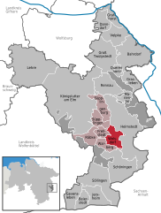  | |
 Wolsdorf  Wolsdorf | |
| Coordinates: 52°12′N10°57′E / 52.200°N 10.950°E Coordinates: 52°12′N10°57′E / 52.200°N 10.950°E | |
| Country | Germany |
| State | Lower Saxony |
| District | Helmstedt |
| Municipal assoc. | Nord-Elm |
| Government | |
| • Mayor | Heinz Schmidt |
| Area | |
| • Total | 13.17 km2 (5.08 sq mi) |
| Elevation | 133 m (436 ft) |
| Population (2019-12-31) [1] | |
| • Total | 911 |
| • Density | 69/km2 (180/sq mi) |
| Time zone | CET/CEST (UTC+1/+2) |
| Postal codes | 38379 |
| Dialling codes | 05355 |
| Vehicle registration | HE |
| Website | www.samtgemeinde-nord-elm.de |
Wolsdorf is a municipality in the district of Helmstedt, in Lower Saxony, Germany.


