Hennepin County is a county in the U.S. state of Minnesota. Its county seat is Minneapolis, the state's most populous city. The county is named for the 17th-century explorer Louis Hennepin. It extends from Minneapolis to the suburbs and outlying cities in the western part of the county. Its natural areas are covered by extensive woods, hills, and lakes. As of the 2020 census, the population was 1,281,565. It is Minnesota's most populous county and the 34th-most populous county in the U.S.; more than one in five Minnesotans live in Hennepin County. It is included in the Minneapolis–Saint Paul–Bloomington Metropolitan Statistical Area.

In the United States, trolley parks, which started in the 19th century, were picnic and recreation areas along or at the ends of streetcar lines in most of the larger cities. These were precursors to amusement parks. Trolley parks were often created by the streetcar companies to give people a reason to use their services on weekends.

Nicollet Avenue is a major street in Minneapolis, Richfield, Bloomington, and Burnsville in the U.S. state of Minnesota. It passes through a number of locally well-known neighborhoods and districts, notably Eat Street in south Minneapolis and the traffic-restricted Nicollet Mall in downtown Minneapolis.

Whittier is a neighborhood within the Powderhorn community in the U.S. city of Minneapolis, Minnesota, bounded by Franklin Avenue on the north, Interstate 35W on the east, Lake Street on the south, and Lyndale Avenue on the west. It is known for its many diverse restaurants, coffee shops and Asian markets, especially along Nicollet Avenue. The neighborhood is home to the Minneapolis Institute of Art, the Minneapolis College of Art and Design, and the Children's Theatre Company.

Minneapolis is officially defined by its city council as divided into 83 neighborhoods. The neighborhoods are historically grouped into 11 communities. Informally, there are city areas with colloquial labels. Residents may also group themselves by their city street suffixes: North, Northeast, South, and Southeast.

Lowry Hill East, also known as the Wedge because of its wedge-like shape, is a neighborhood in southwest Minneapolis, Minnesota, United States, part of the Calhoun Isles community. It is bounded on the east by Lyndale Avenue, on the west by Hennepin Avenue and on the south by Lake Street. Lyndale and Hennepin intersect on the northern side at Interstate 94. This creates a neighborhood roughly triangular in shape.

The Cooper neighborhood resides along the west shore of the Mississippi River in south Minneapolis. It is bound by 34th St. E. on the south, 38th Ave. S. on the west, 27th St. E. on the north, and the river gorge to the east. Bordering neighborhoods are Seward to the north, Longfellow to the west, and Howe to the south. St. Paul's Merriam Park neighborhood is just across the Mississippi River to the east.

Lake Street is a major east-west thoroughfare between 29th and 31st streets in Minneapolis, Minnesota United States. From its western most end at the city's limits, Lake Street reaches the Chain of Lakes, passing over a small channel linking Bde Maka Ska and Lake of the Isles, and at its eastern most end it reaches the Mississippi River. In May 2020, the Lake Street corridor suffered extensive damage during local unrest following the murder of George Floyd. In August of the same year, city officials designated East Lake Street as one of seven cultural districts to promote racial equity, preserve cultural identity, and promote economic growth.

The Midtown Greenway is a 5.7-mile (9.2 km) rail trail in Minneapolis, Minnesota that follows the path of an abandoned route of the Milwaukee Road railway. It is considered under segregated cycle facilities.

Westminster Presbyterian Church is a Presbyterian Church located in downtown Minneapolis, Minnesota. Its current location is the third location in downtown in over 140 years. The building is listed on the National Register of Historic Places.
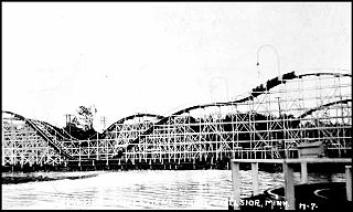
Excelsior Amusement Park was an amusement park on Lake Minnetonka in the town of Excelsior, Minnesota, United States. The park, which operated from 1925 to 1973, was a popular destination for company picnics and day trips from the Twin Cities.

Longfellow, also referred to as Greater Longfellow is a defined community in Minneapolis, Minnesota which includes five smaller neighborhoods inside of it: Seward, Cooper, Hiawatha, Howe and Longfellow. The community is a mix of agri-industrial properties along the old Northern Pacific Railway, expansive parkland surrounding the famous Minnehaha Falls, and smaller residential areas.

Como is a neighborhood within the Southeast quadrant of Minneapolis. The neighborhood is also sometimes referred to as Southeast Como to help differentiate it from the Como Park neighborhood in neighboring Saint Paul. Its boundaries are East Hennepin Avenue to the north, 33rd Avenue Southeast to the east, the Southeast Industrial Area to the south, and Interstate 35W to the west. Como is also part of the University District in Minneapolis, with its location near the main Minneapolis campus of the University of Minnesota.
Waite Park is a neighborhood in the Northeast community in Minneapolis, Minnesota. Its boundaries are 37th Avenue NE to the north, NE Stinson Boulevard to the East, Saint Anthony Parkway to the south, and NE Central Avenue to the west. It is the furthest northeast neighborhood within Minneapolis. It is one of ten neighborhoods in Ward 1 of Minneapolis, currently represented by Council President Elliott Payne, and falls under the jurisdiction of the second precinct of the Minneapolis Police Department.

Lynnhurst is a neighborhood in the Southwest community in Minneapolis, Minnesota. Its boundaries are 46th Street to the north, Lyndale Avenue to the east, 54th Street to the south, and Penn Avenue to the west. It is located along the southeastern shore of Lake Harriet. Outflows from the lake run through a parkway for several city blocks to reach Minnehaha Creek.

Indianola Park was a trolley park that operated in Columbus, Ohio's University District from 1905 to 1937. The amusement park was created by Charles Miles and Frederick Ingersoll, and peaked in popularity in the 1910s, entertaining crowds of up to 10,000 with the numerous roller coasters and rides, with up to 5,000 in the massive pool alone. The park was also the home field for the Columbus Panhandles for half of a decade. In the 1920s, new owners bought and remodeled the park, and it did well until it closed at the end of the Great Depression.

White City was a recreational area located in the Greater Grand Crossing and Woodlawn community areas on the south side of Chicago from 1905 until the 1950s. At the time of its opening, on May 26, 1905, it was claimed to be the largest park of its type in the United States. It contributed to Chicago's status as the city with the most amusement parks in the United States until 1908. It eventually introduced the world to the Goodyear Blimp, which was first assembled at the park.
Cedar Avenue is a roadway that runs from Minneapolis to Northfield in the U.S. state of Minnesota. The roadway is known as Minnesota State Highway 77 in the busiest portion of the route, from Minneapolis to Apple Valley. The portions north and south of this are county roads, Hennepin County 152 and Dakota County 23, respectively. Its northern terminus in Minneapolis is at Washington Avenue in Cedar-Riverside, though its alignment is briefly interrupted by an interchange at Hiawatha Avenue to the south.
Liebenberg and Kaplan (L&K) was a Minneapolis architectural firm founded in 1923 by Jacob J. Liebenberg and Seeman I. Kaplan. Over a fifty-year period, L&K became one of the Twin Cities' most successful architectural firms, best known for designing/redesigning movie theaters. The firm also designed hospitals, places of worship, commercial and institutional buildings, country clubs, prestigious homes, radio and television stations, hotels, and apartment buildings. After designing Temple Israel and the Granada Theater in Minneapolis, the firm began specializing in acoustics and theater design and went on to plan the construction and/or renovation of more than 200 movie houses throughout Minnesota, North and South Dakota, Iowa, and Wisconsin. Architectural records, original drawings, and plans for some 2,500 Liebenberg and Kaplan projects are available for public use at the Northwest Architectural Archives.

Charles Sumner Sedgwick was an American architect based in Minneapolis, Minnesota.