
The Shire of Baw Baw is a local government area in Victoria, Australia, in the eastern part of the state. It covers an area of 4,028 square kilometres (1,555 sq mi) and in 2021 had a population of 57,626.

The Shire of Mansfield is a local government area in the Hume region of Victoria, Australia, located in the north-east part of the state. It covers an area of 3,844 square kilometres (1,484 sq mi) and in August 2021, had a population of 10,178.

Mansfield is a small town in the foothills of the Victorian Alps in the Australian state of Victoria. It is approximately 180 kilometres (110 mi) north-east of Melbourne by road. The population of Mansfield was 5,541 at the 2021 census.

In Australia, a station is a large landholding used for producing livestock, predominantly cattle or sheep, that needs an extensive range of grazing land. The owner of a station is called a pastoralist or a grazier, corresponding to the North American term "rancher".
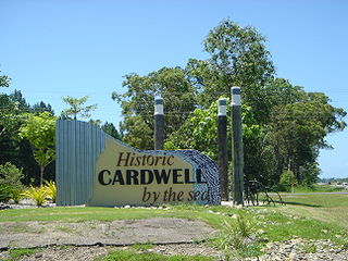
Cardwell is a coastal town and rural locality in the Cassowary Coast Region, Queensland, Australia. In the 2021 census, the locality of Cardwell had a population of 1,320 people.

The Moonee Ponds Creek Trail is a shared use path for cyclists and pedestrians, which follows the Moonee Ponds Creek through the northern suburbs of Melbourne, Victoria, Australia.

The Victorian Alps, also known locally as the High Country, is a large mountain system in the southeastern Australian state of Victoria. Occupying the majority of eastern Victoria, it is the southwestern half of the Australian Alps, the tallest portion of the Great Dividing Range. The Yarra and Dandenong Ranges, both sources of rivers and drinking waters for Melbourne, are branches of the Victorian Alps.

The Mitchell River is a perennial river of the East Gippsland catchment, located in the Australian state of Victoria. The unregulated river provides a unique example of riparian ecology, flowing generally south with the catchment area drawing from the steep mountains of the Victorian Alps to enter Lake King, one of the Gippsland Lakes, and then empty into the Bass Strait.

The Walhalla railway line was a 2 ft 6 in narrow gauge railway located in Gippsland, Victoria, Australia. The line ran from Moe to the former gold-mining town and popular tourist destination of Walhalla. Construction began in 1904. The line closed in sections from 1944 to 1954.

Mount Stirling is a mountain in the Victorian Alps of the Great Dividing Range, located in the Hume region of Victoria, Australia. The mountain has an elevation of 1,747–1,749 metres (5,732–5,738 ft) above sea level.

The Shire of Upper Yarra was a local government area centred on the upper reaches of the Yarra Valley, about 60 kilometres (37 mi) east of Melbourne, the state capital of Victoria, Australia, extending eastwards into Victoria's interior. The shire covered an area of 1,732 square kilometres (668.7 sq mi), and existed from 1888 until 1994.

The City of Traralgon was a local government area about 160 kilometres (99 mi) east-southeast of Melbourne, the state capital of Victoria, Australia, in the Latrobe Valley region. The city covered an area of 22.37 square kilometres (8.64 sq mi), and existed from the time of its severance from the Shire of Traralgon in 1961 until 1994.
I Can Jump Puddles is a 1981 Australian television mini-series based on the 1955 autobiography of the same name by author Alan Marshall. Adapted for television by screenwriters Cliff Green and Roger Simpson, the series starred Lewis Fitz-Gerald, Adam Garnett, Tony Barry, Julie Hamilton, Ann Henderson, Lesley Baker, Olivia Brown, Debra Lawrance and Darren MacDonald.

Mansfield is a former railway station in Mansfield, Victoria, Australia. The former station building now serves tourists to the community as a visitor centre.
The Wonnangatta murders occurred in late 1917 and 1918, in the remote Wonnangatta Valley in East Gippsland, Victoria, Australia. The victims were Jim Barclay, the manager of Wonnangatta Station, and John Bamford, a cook and general hand. Barclay was a well-respected and much-liked bushman, while Bamford was regarded with suspicion, and was known to be easily roused into violent tempers. The case has never been solved.
Cuppacumbalong is an historic homestead located near the southern outskirts of Canberra in the Australian Capital Territory. It is also the name of a former 4,000-acre (16 km2) sheep and cattle grazing property that surrounded the homestead near the junction of the Murrumbidgee and Gudgenby Rivers. The word Cuppacumbalong is Aboriginal in origin and means 'meeting of the waters'. One of the property's early owners Leopold Fane De Salis made a noteworthy contribution to political life during colonial times and furthermore, Cuppacumbalong has strong connections to the life of William Farrer, the father of the Australian wheat industry.

The Walhalla Goldfields Rail Easement is a 7.7 kilometre trail which follows the former route of the narrow gauge Walhalla railway line between Erica and Thomson station, near Walhalla in Victoria's east. Another small section of the former line, which runs through Moondarra State Park between Moe and Erica, also opens as the unofficial Moondarra Rail Trail.
Cobra Station is a pastoral lease and sheep station located in the Gascoyne region of Western Australia.
Maroonah Station, often referred to as Maroonah, is a pastoral lease that operates as a sheep station.
"The Forget-Me-Knot" is the first episode of the sixth series of the 1960s cult British spy-fi television series The Avengers, starring Patrick Macnee and Diana Rigg, and introducing Linda Thorson as Tara King. Its first broadcast was on the US ABC network on 20 March 1968. Its first UK broadcast was on 25 September 1968 by Thames Television, who commissioned this series of the show for the ITV network. The episode was directed by James Hill, and written by Brian Clemens.

