Peachtree Creek is a major stream in Atlanta. It flows for 7.5 miles (12.1 km) almost due west into the Chattahoochee River just south of Vinings.

The Big Wood River is a 137-mile-long (220 km) river in central Idaho, United States, that is a tributary of the Malad River.
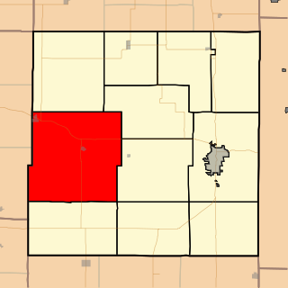
Marion Township is a township in Bourbon County, Kansas, USA. As of the 2000 census, its population was 1,165.

The South Fork Kings River is a 44.1-mile (71.0 km) tributary of the Kings River in the Sierra Nevada of Fresno County, California. The river forms part of Kings Canyon, the namesake of Kings Canyon National Park and one of the deepest canyons in North America with a maximum relief of 8,200 feet (2,500 m) from rim to river.

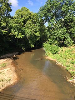
Oaks Creek is a river that drains Canadarago Lake, which is situated in the north central region of Otsego County, New York. The creek begins by the Hamlet of Schuyler Lake and flows southeast approximately 9.32 miles (15.00 km), dropping only 105 feet (32 m) in elevation, before converging with the Susquehanna River south of the Village of Cooperstown, by the Hamlet of Index. From the source to Oaksville the creek flows along Panther Mountain. Fly Creek is a main tributary, that converges with Oaks Creek south of the Hamlet of Fly Creek.

The Canajoharie Creek is a river that flows into the Mohawk River in the Village of Canajoharie in the U.S. State of New York. The name "Canajoharie" is said to be a Mohawk language term meaning "the pot that washes itself," referring to the "Canajoharie Boiling Pot," a 20 feet (6.1 m) wide and 10 feet (3.0 m) deep pothole in the Canajoharie Creek, just south of the Village of Canajoharie. Bowmans Creek is one main tributary that enters the creek east of the Hamlet of Sprout Brook. The other main tributary is Brimstone Creek which enters the creek north-northwest of the Village of Ames.
The Nowadaga Creek basin drains portions of the towns of Danube, Stark, and Little Falls, as well as a small portion of the town of Warren, in southern Herkimer County before converging with the Mohawk River in Indian Castle, New York. The drainage basin is approximately 49 percent forested. The creek has an average slope of 1.7 percent over its entire stream length of 10.0 miles. On a 1790 land patent map it is spelled "Inchanando Creek".
Fulmer Creek flows into the Mohawk River in Mohawk, New York. The creek derives its name from the "Felmore" family, who bought land through the Burnetsfield patent of 1725, in which lands on the present village site were granted out.
Steele Creek begins in an unnamed swamp south of Cedarville and flows northeast before emptying into the Mohawk River in the Village of Ilion, New York. Steele Creek travels through the Ilion Gorge and alongside NY-51 for most of its length. Steele Creek derives its name from Rudolph Stahl, who built the first grist mill in Ilion along the creek.
Moyer Creek starts at Wheelock Pond near Jerusalem Hill, New York. Past Gulph, New York Moyer Creek follows a deep ravine, the Frankfort Gorge, south towards Frankfort, New York before converging with the Mohawk River in Frankfort, New York. The headwaters of Moyer Creek rise within a half mile of the source of the Unadilla River which is the most northerly headwater source of the Susquehanna and the closest to the Mohawk River.

Caroga Creek is a river in Fulton County in the U.S. State of New York. It begins at East Caroga Lake and flows south passing through Rockwood Lake before converging with the Mohawk River in the Hamlet of Palatine Church.
Cayadutta Creek flows into the Mohawk River near Fonda, New York. The Indian meaning of Cayadutta is "rippling waters" or "shallow water running over stones". This stream has commercial and historical importance as the cities of Johnstown and Gloversville lie on its banks.
The Cobleskill Creek starts at the mouth of the Schenevus Creek in Richmondville, New York. It flows through Cobleskill, New York before converging with the Schoharie Creek in Central Bridge, New York.

The Schenevus Creek is a river located in southern Otsego County, New York. The creek flows through Worcester and Schenevus before converging with the Susquehanna River in Colliersville, New York.
Charlotte Creek is a river located in Delaware County, New York. Charlotte Creek borders the southern border of Otsego County, New York for a few miles near the mouth. The creek converges with the Susquehanna River by Emmons, New York.
Pail Shop Corners is a hamlet located at the corner of Hoke Road, Goose Street, and CR-26 north of Fly Creek in the Town of Otsego, in Otsego County, New York, United States. The Fly Creek Cider Mill and Orchard is located by Pail Shop Corners.
Panther Mountain is a mountain located in Central New York of New York near Fly Creek, New York and Schuyler Lake, New York. The east side of Panther Mountain drains into Fly Creek and the west side drains into Oaks Creek and Canadarago Lake.
Badeau Hill is a mountain located in Central New York region of New York northwest of Elk Creek, New York.
Gifford Hill is a small mountain chain in the Central New York Region of New York. It is located northeast of Oneonta, New York. It is made of three main peaks the highest being 1928 feet. Gifford Hill is named for the Gifford Family who moved to the area in 1803 and settled along the Oneonta Creek on what is now called Gifford Hill.
