Wood River (Wisconsin)

Last updated

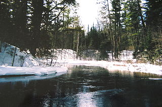
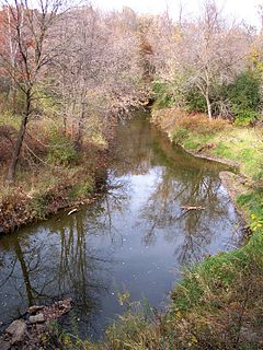
The Wood River is a 47.7-mile-long (76.8 km) [1] tributary of the St. Croix River in western Burnett County, Wisconsin, United States. [2] It follows a meandering course in a generally westward direction. Its banks are mostly low and marshy, though there are high sandbanks in places. Although it flows through a few communities, for most of its course it flows through relatively natural settings.

St. Croix River (Wisconsin–Minnesota) river in Wisconsin and Minnesota, United States

The St. Croix River is a tributary of the Mississippi River, approximately 169 miles (272 km) long, in the U.S. states of Wisconsin and Minnesota. The lower 125 miles (201 km) of the river form the border between Wisconsin and Minnesota. The river is a National Scenic Riverway under the protection of the National Park Service. A hydroelectric plant at St. Croix Falls supplies power to the Minneapolis–St. Paul metropolitan area.

Burnett County, Wisconsin county in Wisconsin, US

Burnett County is a county located in the U.S. state of Wisconsin. As of the 2010 census, the population was 15,457. Its county seat is Siren, with the majority of county governmental services located at the Burnett County Government Center. The county was created in 1856 and organized in 1865.

Its source can be traced to Wood Creek which drains wetlands near the village of Frederic, Wisconsin in Polk County. Wood Creek runs through the unincorporated settlement of Falun, located in the town of Daniels, Burnett County, and eventually empties into Little Wood Lake. Little Wood Lake is drained by the Little Wood River which flows a few miles westward to Big Wood Lake, located in the town of Wood River.

Frederic, Wisconsin Village in Wisconsin, United States

Frederic is a village in Polk County, Wisconsin, United States. The population was 1,137 at the 2010 census.

Polk County, Wisconsin county in Wisconsin, United States

Polk County is a county in the U.S. state of Wisconsin. As of the 2010 census, the population was 44,205. Its county seat is Balsam Lake. The county was created in 1853.

The Wood River proper begins at the north end of Big Wood Lake. It flows north several miles before it arcs back through the village of Grantsburg and on to the St. Croix River, several miles south of State Highway 70.

Grantsburg, Wisconsin Village in Wisconsin, United States

Grantsburg is a village in Burnett County in the U.S. state of Wisconsin. The population was 1,341 at the 2010 census. The village is located within the Town of Grantsburg. It was established by Canute Anderson.

Wisconsin Highway 70 highway in Wisconsin

State Trunk Highway 70 is a state highway in the U.S. state of Wisconsin. It runs east–west in northern Wisconsin from a shared terminus with WIS 101 at US 2 and US 141 near Florence to a connection with Minnesota State Highway 70 at the St. Croix River 5 miles (8.0 km) west of Grantsburg in Burnett County. It serves the communities of Grantsburg, Siren, Spooner, and the resort areas of Minocqua, Woodruff and Eagle River along its route. WIS 70 is the third most northern route to almost completely cross Wisconsin, stretching from Minnesota to within 4 miles (6.4 km) of the Michigan border.

In the Ojibwe language, this river was called Wiigobimizh-ziibi (Basswood River) because of the abundance of this tree, from which strips of softened inner bark were used as lashings or cording called wiigob. Because of the wetland complex through which the Wood River flows, the Ojibwe called the vicinity of the village of Grantsburg Gichi-Mashkiigiminakaaning (at the great place full of low-bush cranberries).

Ojibwe language language

Ojibwe, also known as Ojibwa, Ojibway or Otchipwe, is an indigenous language of North America of the Algonquian language family. The language is characterized by a series of dialects that have local names and frequently local writing systems. There is no single dialect that is considered the most prestigious or most prominent, and no standard writing system that covers all dialects.

Cranberry subgenus of plants

Cranberries are a group of evergreen dwarf shrubs or trailing vines in the subgenus Oxycoccus of the genus Vaccinium. In Britain, cranberry may refer to the native species Vaccinium oxycoccos, while in North America, cranberry may refer to Vaccinium macrocarpon. Vaccinium oxycoccos is cultivated in central and northern Europe, while Vaccinium macrocarpon is cultivated throughout the northern United States, Canada and Chile. In some methods of classification, Oxycoccus is regarded as a genus in its own right. They can be found in acidic bogs throughout the cooler regions of the Northern Hemisphere.

Related Research Articles

Grantsburg is a town in Burnett County in the U.S. state of Wisconsin. The population was 1,136 at the 2010 census. The village of Grantsburg is located within the town. The unincorporated communities of Branstad and Lind are located in the town.

Alpha, Wisconsin Unincorporated community in Wisconsin, United States

Alpha is an unincorporated community in the town of Wood River, Burnett County, Wisconsin, United States. The community is located in the western part of the county, in northwestern Wisconsin. There are fewer than a dozen households in the community.

Ahnapee River river on the Door Peninsula in Wisconsin

The Ahnapee River is a 14.7-mile-long (23.7 km) river on the Door Peninsula in eastern Wisconsin in the United States. It rises in Door County, Wisconsin, and flows through Kewaunee County into Lake Michigan at the city of Algoma. Its name has been ascribed as coming from the Ojibwe word aanapii meaning "when?".

Eau Claire River (Chippewa River tributary) river in the United States of America

The Eau Claire River is a tributary of the Chippewa River in west-central Wisconsin in the United States. It is one of three rivers by this name in Wisconsin. Via the Chippewa River, it is part of the Mississippi River watershed. Its name is the French translation from the Ojibwe Wayaa-gonaatigweyaa-ziibi.

Snake River (St. Croix River tributary)

The Snake River is a 104-mile-long (167 km) tributary of the St. Croix River in east-central Minnesota in the United States. It is one of three streams in Minnesota with this name. Its name is a translation from the Ojibwa Ginebigo-ziibi, after the Dakota peoples who made their homes along this river. Kanabec County is named after this river.

The Namekagon River is a tributary of the St. Croix River. It is 101 miles (163 km) long and is located in northwestern Wisconsin in the United States. Its course is protected as part of the St. Croix National Scenic Riverway.

The Totagatic River is an 80.0-mile-long (128.7 km) tributary of the Namekagon River in northwestern Wisconsin in the United States. Via the Namekagon and St. Croix rivers, it is part of the watershed of the Mississippi River. According to the Geographic Names Information System, the river's name has also been historically spelled Togatatic and Totogatic. Its name is derived from the Ojibwe language Dootoogaatigo-ziibi meaning "River of Boggy Riverway", due to its course through wetlands.

Apple River (Wisconsin)

The Apple River is a 77.5-mile-long (124.7 km) tributary of the St. Croix River in northwestern Wisconsin in the United States. Via the St. Croix, it is part of the watershed of the Mississippi River.

Black River (Wisconsin) tributary of the Mississippi River near La Crosse, Wisconsin

The Black River is a river in west-central Wisconsin and tributary of the Mississippi River. The river is approximately 190 miles (310 km) long. During the 19th century, pine logs were rafted down the Black, heading for sawmills at La Crosse and points beyond.

Bois Brule River river in Wisconsin, USA, tributary of Lake Superior

The Bois Brule River is located in Douglas County, Wisconsin, United States, near the county's eastern border with Bayfield County. The river is 43.9 miles (70.7 km) long. The source is in central Douglas County near Upper St. Croix Lake, it flows through the Brule River State Forest, and drains into Lake Superior.

Salt River is the name of two streams in the U.S. state of Michigan.

Rice Creek (Mississippi River tributary) river in Minnesota, United States of America

Rice Creek is a tributary of the Mississippi River in the northern suburbs of the Minneapolis–St. Paul metropolitan area of Minnesota in the United States. It is approximately 28 miles (45 km) long and drains a watershed of 201 square miles (520 km2).

Johnson Creek is a minor tributary of the Rock River, about 20.8 miles (33.5 km) long, in southeastern Wisconsin in the United States. Via the Rock River, it is part of the watershed of the Mississippi River. Its watershed lies entirely within Jefferson County.

The Clam River is a 63.4-mile-long (102.0 km) tributary of the St. Croix River in northwestern Wisconsin in the United States. In its history, it has been known by the names Kayeskikan, Kiesca-seba, and "Shell River".

The Trade River is a 50.8-mile-long (81.8 km) tributary of the St. Croix River in northwestern Wisconsin in the United States. In its history, it has been known by the names "Atanwa" or "Ottoway" River, both of which are Anglicized versions of an Ojibwe language word meaning "trade". Beneath the mouth of the Trade River, the St. Croix River was once known as the Grave-marker River.

Straight River (Wisconsin)

The Straight River is a 15.5-mile-long (24.9 km) tributary of the Apple River located entirely within Polk County, Wisconsin in the United States. The Straight River rises in wetlands west of Straight Lake in Straight Lake State Park. After exiting Straight Lake, the river flows generally southeastward toward Big Round Lake in the town of Georgetown. From Big Round, the Straight flows through Little and Big Blake lakes, before meeting Fox Creek, the outlet of Bone Lake. Below the confluence, Fox Creek flows southward for 5.2 miles (8.4 km), roughly parallel to County Road I/H, before meeting the Apple River a few miles west of White Ash Lake within the town of Apple River.

References

  1. U.S. Geological Survey. National Hydrography Dataset high-resolution flowline data. The National Map, accessed October 5, 2012
  2. U.S. Geological Survey Geographic Names Information System: Wood River (Wisconsin)

Coordinates: 45°45′47″N92°47′06″W / 45.76306°N 92.78500°W / 45.76306; -92.78500

Geographic coordinate system Coordinate system

A geographic coordinate system is a coordinate system that enables every location on Earth to be specified by a set of numbers, letters or symbols. The coordinates are often chosen such that one of the numbers represents a vertical position and two or three of the numbers represent a horizontal position; alternatively, a geographic position may be expressed in a combined three-dimensional Cartesian vector. A common choice of coordinates is latitude, longitude and elevation. To specify a location on a plane requires a map projection.