Frederic, Wisconsin

Last updated
Frederic, Wisconsin
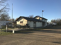
Frederic Depot wider view.jpg
Soo Line Depot Museum in Frederic
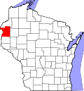
Polk County Wisconsin Incorporated and Unincorporated areas Frederic Highlighted.svg
Location of Frederic in Polk County, Wisconsin.
Coordinates: 45°39′32″N92°28′1″W / 45.65889°N 92.46694°W / 45.65889; -92.46694
Country Flag of the United States.svg  United States
State Flag of Wisconsin.svg  Wisconsin
County Polk
Area
[1]
  Total1.76 sq mi (4.56 km2)
  Land1.69 sq mi (4.38 km2)
  Water0.07 sq mi (0.18 km2)
Elevation
[2]
1,214 ft (370 m)
Population
 (2010) [3]
  Total1,137
  Estimate 
(2019) [4]
1,089
  Density644.00/sq mi (248.62/km2)
Time zone UTC-6 (Central (CST))
  Summer (DST) UTC-5 (CDT)
Area code(s) 715 & 534
FIPS code 55-27500 [5]
GNIS feature ID1565283 [2]
Website www.fredericwi.com

Frederic is a village in Polk County, Wisconsin, United States. The population was 1,137 at the 2010 census. It was established as a village in 1901.

Contents

Geography

Frederic is located at 45°39′32″N92°28′1″W / 45.65889°N 92.46694°W / 45.65889; -92.46694 (45.658797, -92.466921). [6]

According to the United States Census Bureau, the village has a total area of 1.79 square miles (4.64 km2), of which, 1.72 square miles (4.45 km2) of it is land and 0.07 square miles (0.18 km2) is water. [7]

Frederic is along Wisconsin Highways 35 and 48, and Polk County Road W.

Demographics

Historical population
CensusPop.Note
1910 511
1920 60217.8%
1930 68013.0%
1940 7256.6%
1950 89323.2%
1960 857−4.0%
1970 9086.0%
1980 1,03914.4%
1990 1,1248.2%
2000 1,26212.3%
2010 1,137−9.9%
2019 (est.)1,089 [4] −4.2%
U.S. Decennial Census [8]

2010 census

As of the census [3] of 2010, there were 1,137 people, 496 households, and 274 families living in the village. The population density was 661.0 inhabitants per square mile (255.2/km2). There were 567 housing units at an average density of 329.7 per square mile (127.3/km2). The racial makeup of the village was 95.9% White, 0.3% African American, 1.7% Native American, 0.5% Asian, 0.4% from other races, and 1.3% from two or more races. Hispanic or Latino of any race were 1.1% of the population.

There were 496 households, of which 26.8% had children under the age of 18 living with them, 39.1% were married couples living together, 11.1% had a female householder with no husband present, 5.0% had a male householder with no wife present, and 44.8% were non-families. 38.9% of all households were made up of individuals, and 20.5% had someone living alone who was 65 years of age or older. The average household size was 2.16 and the average family size was 2.84.

The median age in the village was 41.4 years. 25.8% of residents were under the age of 18; 4.7% were between the ages of 18 and 24; 23.7% were from 25 to 44; 23.6% were from 45 to 64; and 22.3% were 65 years of age or older. The gender makeup of the village was 46.7% male and 53.3% female.

2000 census

As of the census [5] of 2000, there were 1,262 people, 536 households, and 286 families living in the village. The population density was 820.6 people per square mile (316.4/km2). There were 586 housing units at an average density of 381.1 per square mile (146.9/km2). The racial makeup of the village was 97.78% White, 0.08% African American, 1.19% Native American, 0.16% Asian, and 0.79% from two or more races. Hispanic or Latino of any race were 0.40% of the population.

There were 536 households, out of which 23.1% had children under the age of 18 living with them, 41.0% were married couples living together, 9.1% had a female householder with no husband present, and 46.5% were non-families. 42.2% of all households were made up of individuals, and 25.2% had someone living alone who was 65 years of age or older. The average household size was 2.15 and the average family size was 2.99.

In the village, the population was spread out, with 23.0% under the age of 18, 6.3% from 18 to 24, 22.3% from 25 to 44, 16.9% from 45 to 64, and 31.5% who were 65 years of age or older. The median age was 44 years. For every 100 females, there were 79.0 males. For every 100 females age 18 and over, there were 70.2 males.

The median income for a household in the village was $25,380, and the median income for a family was $40,000. Males had a median income of $30,987 versus $19,813 for females. The per capita income for the village was $15,685. About 5.6% of families and 10.9% of the population were below the poverty line, including 8.5% of those under age 18 and 21.1% of those age 65 or over.
Education

The Frederic School District consists of Frederic Elementary School and Frederic 6-12 School, which contains Frederic Middle School and Frederic High School. [9]

Notable people

Related Research Articles

<span class="mw-page-title-main">Scotia, Nebraska</span> Village in Nebraska, United States

Scotia is a village in Greeley County, Nebraska, United States. The population was 318 at the 2010 census.

<span class="mw-page-title-main">Silver Springs, New York</span> Village in New York, United States

Silver Springs is a village in Wyoming County, New York, United States. The population was 782 at the 2010 census.

<span class="mw-page-title-main">Dexter City, Ohio</span> Village in Ohio, United States

Dexter City is a village in Noble County, Ohio, United States, along the West Fork of Duck Creek. The population was 81 at the 2020 census. Dexter City was laid out in 1870, and named after Dexter W. Sullivan, an early settler.

<span class="mw-page-title-main">Onaka, South Dakota</span> Town in South Dakota, United States

Onaka is a town in Faulk County, South Dakota, United States. The population was 13 at the 2020 census.

<span class="mw-page-title-main">Kekoskee, Wisconsin</span> Village in Wisconsin, United States

Kekoskee is a village in Dodge County, Wisconsin, United States. The population was 161 at the 2010 census.

<span class="mw-page-title-main">Neosho, Wisconsin</span> Village in Wisconsin, United States

Neosho is a village in Dodge County, Wisconsin, United States. The population was 574 at the 2010 census.

<span class="mw-page-title-main">Oliver, Wisconsin</span> Village in Wisconsin, United States

Oliver is a village in Douglas County, Wisconsin, United States. The population was 423 at the 2020 census.

<span class="mw-page-title-main">Brokaw, Wisconsin</span> Village in Wisconsin, United States

Brokaw is a former village in Marathon County, Wisconsin, United States. It is part of the Wausau, Wisconsin Metropolitan Statistical Area. The population was 251 at the 2010 census. Brokaw merged with the village of Maine, Wisconsin on October 1, 2018.

<span class="mw-page-title-main">Bruce, Wisconsin</span> Village in Wisconsin, United States

Bruce is a village in Rusk County, Wisconsin, United States. The population was 779 at the 2010 census. The village was founded in 1884 by the Sault Ste. Marie Land and Improvement Company. The land company was incorporated and led by the principal officers of the Minneapolis, Sault Ste. Marie and Atlantic Railway, which operated its ceremonial first train over its line to Bruce in November 1884. It was named for Alanson C. Bruce who operated a logging camp in the area.

<span class="mw-page-title-main">Glenbeulah, Wisconsin</span> Village in Wisconsin, United States

Glenbeulah is a village in Sheboygan County, Wisconsin, United States. The population was 463 at the 2010 census. It is included in the Sheboygan, Wisconsin Metropolitan Statistical Area. Glenbeulah is situated on the Mullet River.

<span class="mw-page-title-main">Chaseburg, Wisconsin</span> Village in Wisconsin, United States

Chaseburg is a village in Vernon County, Wisconsin, United States. The population was 284 at the 2010 census.

<span class="mw-page-title-main">Dorchester, Wisconsin</span> Village in Wisconsin, United States

Dorchester is a village in Clark and Marathon counties in the U.S. state of Wisconsin, along the 45th parallel. It is part of the Wausau, Wisconsin Metropolitan Statistical Area. The population was 876 at the 2010 census. Of this, 871 were in Clark County, and only 5 were in Marathon County.

<span class="mw-page-title-main">Viola, Wisconsin</span> Village in Wisconsin, United States

Viola is a village in Richland (mostly) and Vernon Counties in the U.S. state of Wisconsin, United States. The population was 699 at the 2010 census. Of this, 477 were in Richland County, and 222 were in Vernon County.

<span class="mw-page-title-main">Mount Hope, Wisconsin</span> Village in Wisconsin, United States

Mount Hope is a village in Grant County, Wisconsin, United States. The population was 225 at the 2010 census. The village is located within the Town of Mount Hope.

<span class="mw-page-title-main">Melrose, Wisconsin</span> Village in Wisconsin, United States

Melrose is a village in Jackson County, Wisconsin, United States. The population was 503 at the 2010 census. The village is located within the Town of Melrose.

<span class="mw-page-title-main">Balsam Lake, Wisconsin</span> Village in Wisconsin, United States

Balsam Lake is a village in, and the county seat of Polk County, Wisconsin, United States. The population was 1,009 at the 2010 census. The village is located within the Town of Balsam Lake.

<span class="mw-page-title-main">Milltown, Wisconsin</span> Village in Wisconsin, United States

Milltown is a village in Polk County, Wisconsin, United States. The population was 917 at the 2010 census. The village is located within the Town of Milltown.

<span class="mw-page-title-main">Hawkins, Wisconsin</span> Village in Wisconsin, United States

Hawkins is a village in Rusk County, Wisconsin, United States. The population was 305 at the 2010 census. The village is located within the Town of Hawkins.

<span class="mw-page-title-main">Aniwa, Wisconsin</span> Village in Wisconsin, United States

Aniwa is a village in Shawano County, Wisconsin, United States. The population was 260 at the 2010 census. The village is located within the Town of Aniwa. U.S. Route 45 runs north–south through the village.

<span class="mw-page-title-main">Scandinavia, Wisconsin</span> Village in Wisconsin, United States

Scandinavia is a village in the Town of Scandinavia in Waupaca County, Wisconsin, United States. The population was 328 at the 2010 census.

References

  1. "2019 U.S. Gazetteer Files". United States Census Bureau. Retrieved August 7, 2020.
  2. 1 2 "US Board on Geographic Names". United States Geological Survey. 2007-10-25. Retrieved 2008-01-31.
  3. 1 2 "U.S. Census website". United States Census Bureau . Retrieved 2012-11-18.
  4. 1 2 "Population and Housing Unit Estimates". United States Census Bureau. May 24, 2020. Retrieved May 27, 2020.
  5. 1 2 "U.S. Census website". United States Census Bureau . Retrieved 2008-01-31.
  6. "US Gazetteer files: 2010, 2000, and 1990". United States Census Bureau. 2011-02-12. Retrieved 2011-04-23.
  7. "US Gazetteer files 2010". United States Census Bureau. Archived from the original on 2012-07-02. Retrieved 2012-11-18.
  8. "Census of Population and Housing". Census.gov. Retrieved June 4, 2015.
  9. "Welcome to Frederic School District". www.frederic.k12.wi.us. Retrieved 19 July 2018.
  10. "Biography". Pennsylvania State University Libraries. Archived from the original on 2016-03-04.