Beaver, Polk County, Wisconsin

Last updated

Beaver, Wisconsin
WIMap-doton-Beaver c.png
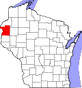
Location of Beaver, Polk County, Wisconsin
Coordinates: 45°24′53″N92°13′3″W / 45.41472°N 92.21750°W / 45.41472; -92.21750
Country Flag of the United States.svg  United States
State Flag of Wisconsin.svg  Wisconsin
County Polk
Area
  Total36.8 sq mi (95.3 km2)
  Land35.3 sq mi (91.4 km2)
  Water1.5 sq mi (3.9 km2)
Elevation
[1]
1,198 ft (365 m)
Population
 (2000)
  Total753
  Density21.3/sq mi (8.2/km2)
Time zone UTC-6 (Central (CST))
  Summer (DST) UTC-5 (CDT)
Area codes 715 & 534
FIPS code 55-05825 [2]
GNIS feature ID1582775 [1]

Beaver is a town in Polk County, Wisconsin, United States. The population was 753 at the 2000 census. The village of Turtle Lake and the unincorporated community of Range are located partially in the town.

Contents

History

On November 11, 1885, the township of Beaver was established. [3]

Geography

According to the United States Census Bureau, the town has a total area of 36.8 square miles (95.3 km2), of which, 35.3 square miles (91.4 km2) of it is land and 1.5 square miles (3.9 km2) of it (4.10%) is water.

Demographics

As of the census [2] of 2000, there were 753 people, 304 households, and 217 families residing in the town. The population density was 21.3 people per square mile (8.2/km2). There were 441 housing units at an average density of 12.5 per square mile (4.8/km2). The racial makeup of the town was 97.21% White, 1.33% Native American, 0.13% Asian, 0.53% from other races, and 0.80% from two or more races. Hispanic or Latino of any race were 0.40% of the population.

There were 304 households, out of which 28.3% had children under the age of 18 living with them, 60.5% were married couples living together, 7.9% had a female householder with no husband present, and 28.3% were non-families. 23.7% of all households were made up of individuals, and 7.9% had someone living alone who was 65 years of age or older. The average household size was 2.48 and the average family size was 2.91.

In the town, the population was spread out, with 24.2% under the age of 18, 5.2% from 18 to 24, 27.1% from 25 to 44, 31.1% from 45 to 64, and 12.5% who were 65 years of age or older. The median age was 40 years. For every 100 females, there were 108.6 males. For every 100 females age 18 and over, there were 106.9 males.

The median income for a household in the town was $40,114, and the median income for a family was $45,000. Males had a median income of $36,932 versus $20,921 for females. The per capita income for the town was $18,242. About 4.9% of families and 7.1% of the population were below the poverty line, including 3.0% of those under age 18 and 19.1% of those age 65 or over.

Related Research Articles

<span class="mw-page-title-main">Millport, Alabama</span> Town in Alabama, United States

Millport is a town in Lamar County, Alabama, United States. It incorporated in 1887. At the 2010 census the population was 1,049, down from 1,160 in 2000. After its incorporation from 1890 to 1900, it was the largest town in Lamar County, losing the distinction to Sulligent. Since 1940, it has been the 3rd largest town.

<span class="mw-page-title-main">Wayne, Maine</span> Town in the state of Maine, United States

Wayne is a town in Kennebec County, Maine, United States. Wayne is included in the Lewiston-Auburn, Maine metropolitan New England city and town area. The population was 1,129 at the 2020 census. The town was named after Revolutionary War General Anthony Wayne. During the summer, Wayne is home to Camp Androscoggin. A popular recreation spot in central Maine, Wayne is part of the Winthrop Lakes Region. The town is included in the Augusta, Maine micropolitan New England City and Town Area. and included in the Lewiston-Auburn, Maine metropolitan New England city and town area.

<span class="mw-page-title-main">Greene Township, Beaver County, Pennsylvania</span> Township in Pennsylvania, United States

Greene Township is a township in Beaver County, Pennsylvania, United States. The population was 2,194 at the 2020 census. It is part of the Pittsburgh metropolitan area.

<span class="mw-page-title-main">Crystal Lake, Barron County, Wisconsin</span> Town in Wisconsin, United States

Crystal Lake is a town in Barron County in the U.S. state of Wisconsin. The population was 757 at the 2010 census. The unincorporated community of Comstock is located in the town.

<span class="mw-page-title-main">Maple Plain, Wisconsin</span> Town in Wisconsin, United States

Maple Plain is a town in Barron County in the U.S. state of Wisconsin. The population was 803 at the 2010 census.

<span class="mw-page-title-main">Canton, Wisconsin</span> Town in Wisconsin, United States

Canton is a town in Buffalo County in the U.S. state of Wisconsin. The population was 305 at the 2010 census. The ghost town of Springdale was located in the town.

<span class="mw-page-title-main">Beaver, Clark County, Wisconsin</span> Town in Wisconsin, United States

Beaver is a town in Clark County in the U.S. state of Wisconsin. The population was 885 at the 2010 census.

<span class="mw-page-title-main">Washburn, Clark County, Wisconsin</span> Town in Wisconsin, United States

Washburn is a town in Clark County in the U.S. state of Wisconsin. The population was 304 at the 2000 census. The unincorporated community of Shortville is located in the town.

<span class="mw-page-title-main">Calamus, Wisconsin</span> Town in Wisconsin, United States

Calamus is a town in Dodge County, Wisconsin, United States. The population was 1,005 at the 2000 census. The unincorporated community of South Beaver Dam is located in the town. The unincorporated community of Lost Lake is also located partially in the town.

<span class="mw-page-title-main">Clifton, Grant County, Wisconsin</span> Town in Wisconsin, United States

Clifton is a town in Grant County, Wisconsin, United States. The population was 304 at the 2000 census. The unincorporated community of Annaton is located in the town. The town was probably named for Bosman Clifton, a community and religious benefactor who came from Delaware.

<span class="mw-page-title-main">Jamestown, Wisconsin</span> Town in Wisconsin, United States

The Town of Jamestown is located in Grant County, Wisconsin, United States. The population was 2,077 at the 2020 census. The census-designated places of Kieler and Sandy Hook and the unincorporated communities of Fair Play, Louisburg, and Rutledge are located within the town; The unincorporated community of Sinsinawa is located partially in the town. The ghost town of Sinnipee was located in the town.

<span class="mw-page-title-main">Beaver, Marinette County, Wisconsin</span> Town in Wisconsin, United States

Beaver is a town in Marinette County, Wisconsin, United States. The population was 1,123 at the 2000 census. The unincorporated community of Beaver is located in the town.

<span class="mw-page-title-main">Cicero, Wisconsin</span> Town in Wisconsin, United States

Cicero is a town in Outagamie County, Wisconsin, United States. The population was 1,092 at the 2000 census.

<span class="mw-page-title-main">Town of Maine, Wisconsin</span> Town in Wisconsin, United States

Maine is a town in Outagamie County, Wisconsin, United States. The population was 831 at the 2000 census. The unincorporated community of Leeman is located in the town.

<span class="mw-page-title-main">Beaver Brook, Wisconsin</span> Town in Wisconsin, United States

Beaver Brook is a town in Washburn County, Wisconsin, United States. The population was 643 at the 2000 census. The unincorporated communities of Beaver Brook and Chicago Junction are located in the town.

<span class="mw-page-title-main">Evergreen, Washburn County, Wisconsin</span> Town in Wisconsin, United States

Evergreen is a town in Washburn County, Wisconsin, United States. The population was 1,076 at the 2000 census.

Cumberland is a town in Barron County in the U.S. state of Wisconsin. The population was 876 at the 2010 census. The City of Cumberland is located partially within the town.

<span class="mw-page-title-main">Randolph, Wisconsin</span> Village in Wisconsin, United States

Randolph is a village in Columbia and Dodge Counties in the U.S. state of Wisconsin. The population was 1,811 at the 2010 census. Of this, 1,339 were in Dodge County, and 472 were in Columbia County. The village is located at the southeast corner of the Town of Randolph in Columbia County, although only a tiny portion of the village lies within the town. Most of the village lies within the Town of Westford in Dodge County. Small portions also lie within the Town of Fox Lake to the north and the Town of Courtland in Columbia County.

<span class="mw-page-title-main">Beaver Dam (town), Wisconsin</span> Town in Wisconsin, United States

Beaver Dam is a town in Dodge County, Wisconsin, United States. The population was 3,440 at the 2000 census. The City of Beaver Dam is encircled by the town. The unincorporated communities of Beaver Edge, Leipsig and Sunset Beach are located in the town. The ghost town of Clason Prairie was also located in the town.

<span class="mw-page-title-main">Lowell, Wisconsin</span> Village in Wisconsin, United States

Lowell is a village in Dodge County, Wisconsin, United States, along the Beaver Dam River. The population was 340 at the 2010 census. The village is located within the Town of Lowell.

References

  1. 1 2 "US Board on Geographic Names". United States Geological Survey. October 25, 2007. Retrieved January 31, 2008.
  2. 1 2 "U.S. Census website". United States Census Bureau . Retrieved January 31, 2008.
  3. Gard, Robert (2015). The Romance of Wisconsin Place Names (2nd ed.). Madison, WI: Wisconsin Historical Society Press. p. 24. ISBN   978-0-87020-707-5.