This article relies largely or entirely on a single source .(January 2026) |
Range, Wisconsin | |
|---|---|
 Range, Wisconsin  Range, Wisconsin | |
| Coordinates: 45°23′44″N92°17′05″W / 45.39556°N 92.28472°W | |
| Country | |
| State | |
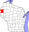
| County | Polk |
| Elevation | 1,168 ft (356 m) |
| Time zone | UTC-6 (Central (CST)) |
| • Summer (DST) | UTC-5 (CDT) |
| Area codes | 715 & 534 |
| GNIS feature ID | 1572071 [1] |
Range is an unincorporated community located in the towns of Apple River and Beaver, Polk County, Wisconsin, United States. [1] It is situated along U.S. Highway 8 and County Road D, 60th Street.