Lorain, Wisconsin

Last updated

Lorain, Wisconsin
WIMap-doton-Lorain.png
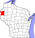
Location of Lorain, Wisconsin
Coordinates: 45°41′38″N92°14′12″W / 45.69389°N 92.23667°W / 45.69389; -92.23667
Country Flag of the United States.svg  United States
State Flag of Wisconsin.svg  Wisconsin
County Polk
Area
  Total37.0 sq mi (95.9 km2)
  Land36.9 sq mi (95.5 km2)
  Water0.1 sq mi (0.3 km2)
Elevation
[1]
1,115 ft (340 m)
Population
 (2000)
  Total328
  Density8.9/sq mi (3.4/km2)
Time zone UTC-6 (Central (CST))
  Summer (DST) UTC-5 (CDT)
Area code(s) 715 & 534
FIPS code 55-45775 [2]
GNIS feature ID1583599 [1]

Lorain is a town in Polk County, Wisconsin, United States. The population was 328 at the 2000 census. The unincorporated community of Indian Creek is located in the town.

Contents

Geography

According to the United States Census Bureau, the town has a total area of 37.0 square miles (95.9 km2), of which, 36.9 square miles (95.5 km2) of it is land and 0.1 square miles (0.3 km2) of it (0.35%) is water.

Demographics

At the 2000 census there were 328 people, 117 households, and 89 families in the town. The population density was 8.9 people per square mile (3.4/km2). There were 173 housing units at an average density of 4.7 per square mile (1.8/km2). The racial makeup of the town was 95.73% White, 2.13% Native American, and 2.13% from two or more races. Hispanic or Latino of any race were 1.83%. [2]

Of the 117 households 31.6% had children under the age of 18 living with them, 66.7% were married couples living together, 3.4% had a female householder with no husband present, and 23.9% were non-families. 22.2% of households were one person and 8.5% were one person aged 65 or older. The average household size was 2.80 and the average family size was 3.26.

The age distribution was 29.3% under the age of 18, 6.7% from 18 to 24, 24.4% from 25 to 44, 24.4% from 45 to 64, and 15.2% 65 or older. The median age was 38 years. For every 100 females, there were 108.9 males. For every 100 females age 18 and over, there were 112.8 males.

The median household income was $25,208 and the median family income was $34,444. Males had a median income of $27,083 versus $15,833 for females. The per capita income for the town was $14,670. About 11.5% of families and 16.0% of the population were below the poverty line, including 25.8% of those under age 18 and 5.5% of those age 65 or over.

Related Research Articles

<span class="mw-page-title-main">Deatsville, Alabama</span> Town in Alabama, United States

Deatsville is a town in Elmore County, Alabama, United States. Although Deatsville initially incorporated in 1903, it lapsed at some point after the 1910 U.S. Census and did not appear again as incorporated until 2000. As of the 2020 census, the population was 1,679.

<span class="mw-page-title-main">Fillmore, Indiana</span> Town in Indiana, United States

Fillmore is a town in Marion Township, Putnam County, in the U.S. state of Indiana. The population was 532 at the 2020 census.

<span class="mw-page-title-main">Linneus, Maine</span> Town in the state of Maine, United States

Linneus is a town in Aroostook County, Maine, United States. The population was 947 at the 2020 census. It is named after Carl Linnaeus.

<span class="mw-page-title-main">West Gardiner, Maine</span> Town in the state of Maine, United States

West Gardiner is a town in Kennebec County, Maine, United States. The population was 3,671 at the 2020 census. West Gardiner is included in the Augusta, Maine micropolitan New England City and Town Area.

Detroit is a town in Somerset County, Maine, United States. The population was 885 at the 2020 census.

<span class="mw-page-title-main">Cutler, Maine</span> Town in the state of Maine, United States

Cutler is a town in Washington County, Maine, United States. The town was named after Joseph Cutler, an early settler, who hailed from Newburyport, Massachusetts. The population was 524 at the 2020 census.

<span class="mw-page-title-main">Deer Creek, Minnesota</span> City in Minnesota, United States

Deer Creek is a city in Otter Tail County, Minnesota, United States. The population was 330 at the 2020 census.

<span class="mw-page-title-main">Hanover, Ohio</span> Village in Ohio, United States

Hanover is a village in Licking County, Ohio, United States. The population was 1,270 at the 2020 census. The village lies along Ohio State Route 16.

<span class="mw-page-title-main">East Sparta, Ohio</span> Village in Ohio, United States

East Sparta is a village in southern Stark County, Ohio, United States. The population was 749 at the 2020 census. It is part of the Canton–Massillon metropolitan area.

Short is a census-designated place (CDP) in Sequoyah County, Oklahoma, United States. It is part of the Fort Smith, Arkansas-Oklahoma Metropolitan Statistical Area. The population was 328 at the 2000 census.

<span class="mw-page-title-main">Jackson Township, Tioga County, Pennsylvania</span> Township in Pennsylvania, United States

Jackson Township is a township in Tioga County, Pennsylvania, United States. The population was 1,880 at the 2020 census.

<span class="mw-page-title-main">Plymouth, Utah</span> Town in Utah, United States

Plymouth is a town in Box Elder County, Utah, United States. The population was 414 at the 2010 census.

<span class="mw-page-title-main">Oakesdale, Washington</span> Town in Washington, United States

Oakesdale is a town in Whitman County, Washington, United States. The population was 422 at the 2010 census.

<span class="mw-page-title-main">Barrackville, West Virginia</span> Town in West Virginia, United States

Barrackville is a town in Marion County, West Virginia, United States. The population was 1,211 at the 2020 census.

<span class="mw-page-title-main">Granville, West Virginia</span> Town in West Virginia

Granville is a town in Monongalia County, West Virginia, United States. The population was 1,355 at the 2020 census. It is included in the Morgantown metropolitan area.

<span class="mw-page-title-main">Durbin, West Virginia</span> Town in West Virginia, United States

Durbin is a town in Pocahontas County, West Virginia, United States. The population was 235 at the 2020 census.

<span class="mw-page-title-main">Gibraltar, Wisconsin</span> Town in Wisconsin, United States

Gibraltar is a town in Door County, Wisconsin, United States. The population was 1,228 at the 2020 census. The unincorporated communities of Fish Creek and Juddville are located in the town.

<span class="mw-page-title-main">Bear Bluff, Wisconsin</span> Town in Wisconsin, United States

Bear Bluff is a town in Jackson County, Wisconsin, United States. The population was 128 at the 2000 census.

<span class="mw-page-title-main">Harrison, Marathon County, Wisconsin</span> Town in Wisconsin, United States

The Town of Harrison is located in the northeast corner of Marathon County, Wisconsin, in the United States. It is part of the Wausau, Wisconsin Metropolitan Statistical Area. As of the 2010 census, the town population was 374. The unincorporated community of Snell is located in the town. The unincorporated community of Hogarty is also located partially in the town.

<span class="mw-page-title-main">Brooklyn, Washburn County, Wisconsin</span> Town in Wisconsin, United States

Brooklyn is a town in Washburn County, Wisconsin, United States. The population was 281 at the 2000 census. The unincorporated community of Lampson is located in the town.

References

  1. 1 2 "US Board on Geographic Names". United States Geological Survey. October 25, 2007. Retrieved January 31, 2008.
  2. 1 2 "U.S. Census website". United States Census Bureau . Retrieved January 31, 2008.