Black Brook, Wisconsin

Last updated

Black Brook, Wisconsin
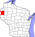
WIMap-doton-Black Brook.png
Location of Black Brook, Wisconsin
Coordinates: 45°14′56″N92°21′8″W / 45.24889°N 92.35222°W / 45.24889; -92.35222
Country Flag of the United States.svg  United States
State Flag of Wisconsin.svg  Wisconsin
County Polk
Area
  Total34.9 sq mi (90.5 km2)
  Land34.2 sq mi (88.7 km2)
  Water0.7 sq mi (1.8 km2)
Elevation
[1]
1,168 ft (356 m)
Population
 (2000)
  Total1,208
  Density35.3/sq mi (13.6/km2)
Time zone UTC-6 (Central (CST))
  Summer (DST) UTC-5 (CDT)
Area codes 715 & 534
FIPS code 55-07700 [2]
GNIS feature ID1582817 [1]

Black Brook is a town in Polk County, Wisconsin, United States. The population was 1,208 at the 2000 census.

Contents

Geography

According to the United States Census Bureau, the town has a total area of 34.9 square miles (90.5 km2), of which, 34.2 square miles (88.7 km2) of it is land and 0.7 square miles (1.8 km2) of it (1.97%) is water.

Demographics

At the 2000 census there were 1,208 people, 419 households, and 326 families in the town. The population density was 35.3 people per square mile (13.6/km2). There were 448 housing units at an average density of 13.1 per square mile (5.1/km2). The racial makeup of the town was 99.01% White, 0.25% Native American, 0.08% from other races, and 0.66% from two or more races. Hispanic or Latino of any race were 0.91%. [2]

Of the 419 households 41.5% had children under the age of 18 living with them, 67.1% were married couples living together, 5.7% had a female householder with no husband present, and 22.0% were non-families. 16.9% of households were one person and 4.3% were one person aged 65 or older. The average household size was 2.88 and the average family size was 3.26.

The age distribution was 31.3% under the age of 18, 6.5% from 18 to 24, 30.7% from 25 to 44, 22.6% from 45 to 64, and 8.9% 65 or older. The median age was 36 years. For every 100 females, there were 109.7 males. For every 100 females age 18 and over, there were 107.0 males.

The median household income was $48,125 and the median family income was $50,543. Males had a median income of $34,554 versus $23,684 for females. The per capita income for the town was $19,286. About 4.7% of families and 6.5% of the population were below the poverty line, including 8.2% of those under age 18 and 1.0% of those age 65 or over.

Related Research Articles

<span class="mw-page-title-main">Riverside, Alabama</span> City in Alabama, United States

Riverside is a city in St. Clair County, Alabama, United States. It incorporated in 1886. At the 2010 census the population was 2,208, up from 1,564 in 2000.

<span class="mw-page-title-main">Knightsville, Indiana</span> Town in Indiana, United States

Knightsville is a town in Van Buren Township, Clay County, Indiana, United States. The population was 872 at the 2010 census. It is part of the Terre Haute Metropolitan Statistical Area.

<span class="mw-page-title-main">Trafalgar, Indiana</span> Town in Indiana, United States

Trafalgar is a town in Nineveh and Hensley townships, Johnson County, Indiana, United States. The population was 1,101 at the 2010 census.

<span class="mw-page-title-main">Parker City, Indiana</span> Town in Indiana, United States

Parker City is a town in Monroe Township, Randolph County, in the U.S. state of Indiana. The population was 1,419 at the 2010 census.

Cornville is a town in Somerset County, Maine, United States. The population was 1,317 at the 2020 census.

<span class="mw-page-title-main">Lanagan, Missouri</span> City in Missouri, United States

Lanagan is a city in McDonald County, Missouri, United States. It is near Truitt's Cave. The population was 419 at the 2010 census.

<span class="mw-page-title-main">Powhatan Point, Ohio</span> Village in Ohio, United States

Powhatan Point is a village in southeastern Belmont County, Ohio, United States, along the Ohio River. The population was 1,461 at the 2020 census. It is part of the Wheeling metropolitan area.

<span class="mw-page-title-main">Amber, Oklahoma</span> Town in Oklahoma, United States

Amber is a town in Grady County, Oklahoma, United States. The population was 413 at the 2020 census, a 1.4% decrease from 2010.

<span class="mw-page-title-main">Timber Lake, South Dakota</span> City in South Dakota, United States

Timber Lake is a city in and the county seat of Dewey County, South Dakota, United States. The population was 509 at the 2020 census.

<span class="mw-page-title-main">Warner, Wisconsin</span> Town in Wisconsin, United States

Warner is a town in Clark County in the U.S. state of Wisconsin. As of the 2000 census, the town had a total population of 627. The unincorporated community of Hemlock is located in the town.

<span class="mw-page-title-main">Washburn, Clark County, Wisconsin</span> Town in Wisconsin, United States

Washburn is a town in Clark County in the U.S. state of Wisconsin. The population was 304 at the 2000 census. The unincorporated community of Shortville is located in the town.

<span class="mw-page-title-main">Wascott, Wisconsin</span> Town in Wisconsin, United States

Wascott is a town in Douglas County, Wisconsin, United States. The population was 714 at the 2000 census. The unincorporated community of Wascott is located in the town.

<span class="mw-page-title-main">Ellenboro, Wisconsin</span> Town in Wisconsin, United States

The Town of Ellenboro is a town located in Grant County, Wisconsin, United States. The population was 608 at the 2000 census.

<span class="mw-page-title-main">Lorain, Wisconsin</span> Town in Wisconsin, United States

Lorain is a town in Polk County, Wisconsin, United States. The population was 328 at the 2000 census. The unincorporated community of Indian Creek is located in the town.

<span class="mw-page-title-main">Mitchell, Wisconsin</span> Town in Wisconsin, United States

Mitchell is a town in Sheboygan County, Wisconsin, United States. The population was 1,132 at the 2000 census. It is included in the Sheboygan, Wisconsin Metropolitan Statistical Area. The unincorporated community of Parnell is located in the town.

<span class="mw-page-title-main">Gale, Wisconsin</span> Town in Wisconsin, United States

Gale is a town in Trempealeau County, Wisconsin, United States. The population was 1,426 at the 2000 census. The unincorporated communities of Butman Corners and Frenchville are located in the town.

<span class="mw-page-title-main">Cross Plains (town), Wisconsin</span>

Cross Plains is a town in Dane County, Wisconsin, United States. The population was 1,419 at the 2000 census. The Village of Cross Plains is located partially within the town. The unincorporated community of Pine Bluff is located in the town.

<span class="mw-page-title-main">Clayton (village), Wisconsin</span> Village in Wisconsin, United States

Clayton is a village in Polk County, Wisconsin, United States. The population was 571 at the 2010 census. The village is located within the Town of Clayton.

<span class="mw-page-title-main">Aniwa (town), Wisconsin</span>

Aniwa is a town in Shawano County, Wisconsin, United States. The population was 586 at the 2000 census. The Village of Aniwa is located within the town.

<span class="mw-page-title-main">Viroqua (town), Wisconsin</span> Town in Wisconsin, United States

Viroqua is a town in Vernon County, Wisconsin, United States. The population was 1,560 at the 2000 census. The City of Viroqua is located within the town.

References

  1. 1 2 "US Board on Geographic Names". United States Geological Survey. October 25, 2007. Retrieved January 31, 2008.
  2. 1 2 "U.S. Census website". United States Census Bureau . Retrieved January 31, 2008.