Bone Lake, Wisconsin

Last updated

Town of Bone Lake
WIMap-doton-Bone Lake.png
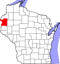
Location of the Town of Bone Lake
Coordinates: 45°34′48″N92°20′26″W / 45.58000°N 92.34056°W / 45.58000; -92.34056
Country Flag of the United States.svg  United States
State Flag of Wisconsin.svg  Wisconsin
County Polk
Area
  Total35.4 sq mi (91.7 km2)
  Land33.6 sq mi (86.9 km2)
  Water1.9 sq mi (4.8 km2)
Elevation
[1]
1,240 ft (378 m)
Population
 (2000)
  Total710
  Density21.2/sq mi (8.2/km2)
Time zone UTC-6 (Central (CST))
  Summer (DST) UTC-5 (CDT)
Area codes 715 & 534
FIPS code 55-08750 [2]
GNIS feature ID1582842 [1]

Bone Lake is a town in Polk County, Wisconsin, United States. The population was 710 at the 2000 census.

Contents

Geography

According to the United States Census Bureau, the town has a total area of 35.4 square miles (92 km2), of which, 33.6 square miles (87 km2) of it is land and 1.9 square miles (4.9 km2) of it (5.25%) is water.

Demographics

As of the census [2] of 2000, there were 710 people, 264 households, and 210 families residing in the town. The population density was 21.2 people per square mile (8.2 people/km2). There were 434 housing units at an average density of 12.9 per square mile (5.0/km2). The racial makeup of the town was 97.46% White, 0.14% African American, 1.41% Native American, 0.28% Asian, and 0.70% from two or more races. Hispanic or Latino of any race were 0.14% of the population.

There were 264 households, out of which 33.3% had children under the age of 18 living with them, 71.6% were married couples living together, 5.3% had a female householder with no husband present, and 20.1% were non-families. 15.9% of all households were made up of individuals, and 8.3% had someone living alone who was 65 years of age or older. The average household size was 2.69 and the average family size was 3.00.

In the town, the population was spread out, with 26.2% under the age of 18, 5.1% from 18 to 24, 26.5% from 25 to 44, 27.2% from 45 to 64, and 15.1% who were 65 years of age or older. The median age was 40 years. For every 100 females, there were 101.1 males. For every 100 females age 18 and over, there were 98.5 males.

The median income for a household in the town was $39,821, and the median income for a family was $45,568. Males had a median income of $32,188 versus $19,375 for females. The per capita income for the town was $16,701. About 6.1% of families and 8.1% of the population were below the poverty line, including 7.7% of those under age 18 and 11.7% of those age 65 or over.

Related Research Articles

<span class="mw-page-title-main">Center Point, Indiana</span> Town in Indiana, United States

Center Point is a town in Sugar Ridge Township, Clay County, Indiana, United States. The population was 242 at the 2010 census. It is part of the Terre Haute Metropolitan Statistical Area.

<span class="mw-page-title-main">Cannelburg, Indiana</span> Town in Indiana, United States

Cannelburg is a town in Barr Township, Daviess County, Indiana, United States. The population was 135 at the 2010 census.

<span class="mw-page-title-main">Glenwood, Indiana</span> Town in Indiana, United States

Glenwood is a town in Union Township, Rush County and in Orange and Fairview townships, Fayette County in the U.S. state of Indiana. The population was 250 at the 2010 census.

<span class="mw-page-title-main">Wolcottville, Indiana</span> Town in Indiana, United States

Wolcottville is a town in Orange Township, Noble County and Johnson Township, LaGrange County in the U.S. state of Indiana. The population was 998 at the 2010 census.

<span class="mw-page-title-main">Poneto, Indiana</span> Town in Indiana, United States

Poneto is a town in Chester, Harrison and Liberty townships, Wells County, in the U.S. state of Indiana. The population was 166 at the 2010 census.

<span class="mw-page-title-main">Moulton, Iowa</span> City in Iowa, United States

Moulton is a city in Appanoose County, Iowa, United States. The population was 607 at the time of the 2020 census.

Burlington is a town in Penobscot County, Maine, United States. It is part of the Bangor Metropolitan Statistical Area. The population was 373 at the 2020 census.

<span class="mw-page-title-main">Rushville, Missouri</span> Village in Missouri, United States

Rushville is a village in western Buchanan County, Missouri, United States. The population was 225 at the 2020 census. It is part of the St. Joseph, MO–KS Metropolitan Statistical Area.

<span class="mw-page-title-main">Powhatan Point, Ohio</span> Village in Ohio, United States

Powhatan Point is a village in southeastern Belmont County, Ohio, United States, along the Ohio River. The population was 1,461 at the 2020 census. It is part of the Wheeling metropolitan area.

<span class="mw-page-title-main">Westport, Oklahoma</span> Town in Oklahoma, United States

Westport is a town in Pawnee County, Oklahoma, United States. The population was 298 at the 2010 census, a gain of 12.9 percent over the figure of 264 in 2000.

<span class="mw-page-title-main">Fairview, West Virginia</span> Town in West Virginia, United States

Fairview is a town in Marion County, West Virginia, United States. The population was 374 at the 2020 census.

<span class="mw-page-title-main">Gilbert, West Virginia</span> Town in West Virginia, United States

Gilbert is a town in Mingo County, West Virginia, United States, along the Guyandotte River. The population was 333 at the 2020 census. Gilbert was incorporated in 1918 and named for Gilbert Creek, which derives its name from the name of an early traveler in the area who was killed by Native Americans. Gilbert is known nationwide for the Hatfield-McCoy ATV Trails that are located in the area. There are a number of lodges and restaurants in Gilbert.

<span class="mw-page-title-main">Cowen, West Virginia</span> Town in West Virginia, United States

Cowen is a town in Webster County, West Virginia, United States. The population was 488 at the 2020 census.

<span class="mw-page-title-main">North Hills, West Virginia</span> Town in West Virginia, United States

North Hills is a town in Wood County, West Virginia, United States. It is a suburb of Parkersburg. The population was 837 at the 2020 census. North Hills was incorporated on February 15, 1979.

<span class="mw-page-title-main">Lakeside, Wisconsin</span> Town in Wisconsin, United States

Lakeside is a town in Douglas County, Wisconsin, United States. The population was 609 at the 2000 census. The town was named for its location at the shore of Lake Superior.

<span class="mw-page-title-main">Paris, Grant County, Wisconsin</span> Town in Wisconsin, United States

Paris is a town in Grant County, Wisconsin, United States. The population was 754 at the 2000 census.

<span class="mw-page-title-main">Cady, Wisconsin</span> Town in Wisconsin, United States

Cady is a town in St. Croix County, Wisconsin, United States. The population was 880 at the 2020 census, up from 821 in the 2010 census and 710 at the 2000 census. The unincorporated community of Hatchville is located partially in the town.

<span class="mw-page-title-main">Black Earth, Wisconsin</span> Village in Wisconsin, United States

Black Earth is a village in Dane County, Wisconsin, United States. The population was 1,338 at the 2010 census. The village is located within the Town of Black Earth. It is part of the Madison Metropolitan Statistical Area.

<span class="mw-page-title-main">Eden, Wisconsin</span> Village in Wisconsin, United States

Eden is a village in Fond du Lac County, Wisconsin, United States. The population was 875 at the 2010 census. The village is located within the Town of Eden.

<span class="mw-page-title-main">Durand (town), Wisconsin</span> Town in Wisconsin, United States

Durand is a town in Pepin County, Wisconsin, United States. The population was 710 at the 2020 census. The City of Durand is located within the town.

References

  1. 1 2 "US Board on Geographic Names". United States Geological Survey. October 25, 2007. Retrieved January 31, 2008.
  2. 1 2 "U.S. Census website". United States Census Bureau . Retrieved January 31, 2008.