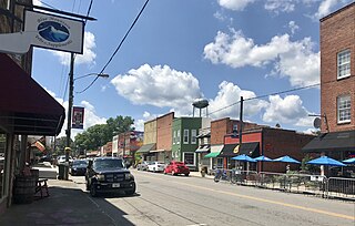
Pilot Mountain is a town in Surry County, North Carolina, United States. The population was 1,443 at the 2020 census. It is named for the nearby landmark of Pilot Mountain, a distinctive geological formation.

Mariemont is a village in eastern Hamilton County, Ohio, United States. The population was 3,518 at the 2020 census. A planned community in the Cincinnati metropolitan area, it includes two overlapping historic districts, the Village of Mariemont and Mariemont Historic District. In 2007, the Village of Mariemont was designated a National Historic Landmark.

Point Township is a township in Northumberland County, Pennsylvania, United States. The population at the 2010 Census was 3,685, a decline from the figure of 3,722 tabulated in 2000.

Grandview is a town in Bayfield County, Wisconsin, United States. The population was 468 at the 2010 census. The unincorporated community of Grand View is located in the town of Grandview.

Medina is a town in Dane County, Wisconsin, United States. The population was 1,235 at the 2000 census. The unincorporated community of Deansville is located in the town.

Waterloo is a town in Grant County in the U.S. state of Wisconsin. The population was 557 at the 2000 census. The unincorporated communities of Burton and McCartney are located in the town.

Garfield is a town in Jackson County, Wisconsin, United States. The population was 638 at the 2010 census. The unincorporated communities of Levis, Price and Requa are located in the town.

Bergen is a town in Marathon County, Wisconsin, United States. It is part of the Wausau, Wisconsin Metropolitan Statistical Area. The population was 740 at the 2020 census. The unincorporated community of Moon is located partially in the town.

Day is a town in southwest Marathon County, Wisconsin, United States. It is part of the Wausau, Wisconsin Metropolitan Statistical Area. The population was 1,085 at the 2010 census. The unincorporated community of Rozellville is located in the town. The unincorporated community of Rangeline is also located partially in the town.

Guenther is a town in Marathon County, Wisconsin, United States. It is part of the Wausau, Wisconsin Metropolitan Statistical Area. The population was 341 at the 2010 census. The unincorporated communities of Ashley and Rocky Corners are located partially in the town.

Silver Cliff is a town in Marinette County, Wisconsin. As of the 2000 census, the town had a population of 529.

Wells is a town in Monroe County, Wisconsin. The population was 529 at the time of the 2000 census. The unincorporated community of Farmers Valley is located partially in the town. The town was named for James Wells, a prominent early settler and the first town chair.

Phillips is a city and the county seat of Price County, Wisconsin, United States. The population was 1,478 at the 2010 census.

Burnside is a town in Trempealeau County, Wisconsin, in the United States. As of the 2000 census, the population was 529. The ghost town of New City was located in the town. The town was named after civil war general Ambrose Burnside.

Wynnedale is a town in Washington Township, Marion County, Indiana, United States. The population was 215 at the 2020 census. It has existed as an "included town" since 1970, when it was incorporated into Indianapolis as part of Unigov. It is part of Indianapolis, but retains a functioning town government under IC 36-3-1-11.
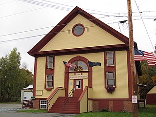
St. Albans is a town in Somerset County, Maine, United States. The population was 2,045 at the 2020 census.

Barron is a city in Barron County, in the U.S. state of Wisconsin. The population was 3,733 at the 2020 census. The city is surrounded by the Town of Barron.

Melrose is a village in Jackson County, Wisconsin, United States. The population was 503 at the 2010 census. The village is located within the Town of Melrose.
Balsam Lake is a town in Polk County, Wisconsin, United States. The population was 1,384 at the 2000 census. The Village of Balsam Lake is located within the town. The unincorporated community of Lykens is also located in the town.
Walworth is a town in Walworth County, Wisconsin, United States. The population was 1,565 at the 2020 census. The Village of Walworth is located within the town. The unincorporated communities of Big Foot Prairie and Delavan Lake are also located partially in the town.

