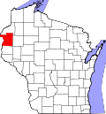
Sterling, Polk County, Wisconsin

Last updated

Sterling, Wisconsin
WIMap-doton-Sterling.png
Location of Sterling, Polk County, Wisconsin
Coordinates: 45°36′15″N92°44′40″W / 45.60417°N 92.74444°W / 45.60417; -92.74444
Country Flag of the United States.svg  United States
State Flag of Wisconsin.svg  Wisconsin
County Polk
Area
  Total64.4 sq mi (166.9 km2)
  Land63.4 sq mi (164.2 km2)
  Water1 sq mi (2.7 km2)
Elevation
[1]
823 ft (251 m)
Population
 (2000)
  Total724
  Density11.4/sq mi (4.4/km2)
Time zone UTC-6 (Central (CST))
  Summer (DST) UTC-5 (CDT)
Area code(s) 715 & 534
FIPS code 55-77050 [2]
GNIS feature ID1584218 [1]

Sterling is a town in Polk County, Wisconsin, United States. The population was 724 at the 2000 census. The unincorporated communities of Cushing and Wolf Creek are located partially in the town.

Contents

Geography

According to the United States Census Bureau, the town has a total area of 64.4 square miles (166.9 km2), of which, 63.4 square miles (164.2 km2) is land and 1.0 square miles (2.7 km2) (1.60%) is water.

Demographics

As of the census [2] of 2000, there were 724 people, 280 households, and 201 families residing in the town. The population density was 11.4 people per square mile (4.4/km2). There were 521 housing units at an average density of 8.2 per square mile (3.2/km2). The racial makeup of the town was 97.93% White, 1.38% Asian, 0.14% from other races, and 0.55% from two or more races. Hispanic or Latino people of any race were 0.97% of the population.

There were 280 households, out of which 33.9% had children under the age of 18 living with them, 58.9% were married couples living together, 5.4% had a female householder with no husband present, and 27.9% were non-families. 21.8% of all households were made up of individuals, and 5.7% had someone living alone who was 65 years of age or older. The average household size was 2.59 and the average family size was 2.99.

In the town, the population was spread out, with 27.9% under the age of 18, 6.1% from 18 to 24, 31.8% from 25 to 44, 23.9% from 45 to 64, and 10.4% who were 65 years of age or older. The median age was 37 years. For every 100 females, there were 110.5 males. For every 100 females age 18 and over, there were 119.3 males.

The median income for a household in the town was $36,042, and the median income for a family was $38,125. Males had a median income of $31,071 versus $23,281 for females. The per capita income for the town was $15,428. About 5% of families and 8.2% of the population were below the poverty line, including 9.3% of those under age 18 and 2.3% of those age 65 or over.

Related Research Articles

<span class="mw-page-title-main">Milltown, Indiana</span> Town in Indiana, United States

Milltown is a town in Whiskey Run Township in Crawford County, Indiana and in Blue River and Spencer townships in Harrison County. The population was 818 at the time of the 2010 census.

<span class="mw-page-title-main">Losantville, Indiana</span> Town in Indiana, United States

Losantville is a town in Union Township, Randolph County, in the U.S. state of Indiana. The population was 237 at the 2010 census.

<span class="mw-page-title-main">Sebago, Maine</span> Town in Maine, United States

Sebago is a town in Cumberland County, Maine, United States. The population was 1,911 at the 2020 census. It is part of the Portland–South Portland–Biddeford, Maine metropolitan statistical area.

<span class="mw-page-title-main">Newcastle, Maine</span> Town in the state of Maine, United States

Newcastle is a town in Lincoln County, Maine, United States. The population was 1,848 at the 2020 census. The village of Newcastle is located in the eastern part of the town, on the Damariscotta River. Together with the village of Damariscotta linked by the Main Street bridge, they form the Twin Villages.

<span class="mw-page-title-main">Rushville, Missouri</span> Village in Missouri, United States

Rushville is a village in western Buchanan County, Missouri, United States. The population was 225 at the 2020 census. It is part of the St. Joseph, MO–KS Metropolitan Statistical Area.

<span class="mw-page-title-main">Minnewaukan, North Dakota</span> City in North Dakota, United States

Minnewaukan is a city in Benson County, North Dakota, United States. It serves as the county seat and is fourth largest city in the county, after Fort Totten, Leeds, and Maddock. The population was 199 at the 2020 census. Minnewaukan was founded in 1884.

<span class="mw-page-title-main">Miller, South Dakota</span> City in South Dakota, United States

Miller is a city in and county seat of Hand County, South Dakota, United States. The population was 1,349 at the 2020 census.

<span class="mw-page-title-main">Riverside, Washington</span> Town in Washington, United States

Riverside is a town in Okanogan County, Washington, United States. The population was 280 at the 2010 census, and increased to 329 at the 2020 census.

<span class="mw-page-title-main">Pratt, West Virginia</span> Town in West Virginia, United States

Pratt is a town in Kanawha County, West Virginia, United States, along the Kanawha River. The population was 482 at the 2020 census.

<span class="mw-page-title-main">West Liberty, West Virginia</span> Town in West Virginia, United States

West Liberty is a town in Ohio County, West Virginia, United States. The population was 1,557 at the 2020 census. It is part of the Wheeling metropolitan area.

<span class="mw-page-title-main">Masontown, West Virginia</span> Town in West Virginia, United States

Masontown is a town in western Preston County, West Virginia, United States. The population was 510 at the 2020 census. It is part of the Morgantown metropolitan area.

<span class="mw-page-title-main">Mill Creek, West Virginia</span> Town in West Virginia, United States

Mill Creek is a town in Randolph County, West Virginia, United States, along the Tygart Valley River. The population was 563 at the 2020 census.

<span class="mw-page-title-main">Elizabeth, West Virginia</span> Town in West Virginia, United States

Elizabeth is a town in and the county seat of Wirt County, West Virginia, United States, situated along the Little Kanawha River. The population was 724 as of the 2020 census.

<span class="mw-page-title-main">Chester, Wisconsin</span> Town in Wisconsin, United States

Chester is a town in Dodge County, Wisconsin. The population was 960 at the 2000 census. The unincorporated communities of Atwater and East Waupun are located in the town.

<span class="mw-page-title-main">Pine River, Wisconsin</span> Town in Wisconsin, United States

Pine River is a town in Lincoln County, Wisconsin. The population was 1,869 at the time of the 2010 census.

<span class="mw-page-title-main">Emery, Wisconsin</span> Town in Wisconsin, United States

Emery is a town in Price County, Wisconsin, United States. The population was 325 at the 2000 census. The unincorporated community of Dover is located in the town.

<span class="mw-page-title-main">Green Valley, Shawano County, Wisconsin</span> Town in Wisconsin, United States

Green Valley is a town in Shawano County, Wisconsin, United States. The population was 1,024 at the 2000 census. The census-designated place of Green Valley and unincorporated communities of Advance and Pulcifer are located in the town.

<span class="mw-page-title-main">Hartland, Shawano County, Wisconsin</span> Town in Wisconsin, United States

Hartland is a town in Shawano County, Wisconsin, United States. The population was 825 at the 2000 census. The unincorporated community of Slab City is located within the town. The unincorporated communities of Frazer Corners and Zachow are also located partially in the town. Hartland was established in 1859.

<span class="mw-page-title-main">Beaver Brook, Wisconsin</span> Town in Wisconsin, United States

Beaver Brook is a town in Washburn County, Wisconsin, United States. The population was 643 at the 2000 census. The unincorporated communities of Beaver Brook and Chicago Junction are located in the town.

<span class="mw-page-title-main">North Crows Nest, Indiana</span> Town in Indiana, United States

North Crows Nest is a town in Washington Township, Marion County, Indiana, United States. It is approximately 7 miles (11 km) north of downtown Indianapolis. The population was 44 at the 2020 census. It has existed as an "included town" since 1970, when it was incorporated into Indianapolis as part of Unigov. It is part of Indianapolis, but retains town governmental powers under IC 36-3-1-11.

References

  1. 1 2 "US Board on Geographic Names". United States Geological Survey. October 25, 2007. Retrieved January 31, 2008.
  2. 1 2 "U.S. Census website". United States Census Bureau . Retrieved January 31, 2008.