Woodlawn, Schenectady, New York

Last updated
Woodlawn

Neighborhood
USA New York location map.svg
Red pog.svg
Woodlawn
Location of Woodlawn within the state of New York
Coordinates: 42°46′40″N73°54′25″W / 42.77778°N 73.90694°W / 42.77778; -73.90694 Coordinates: 42°46′40″N73°54′25″W / 42.77778°N 73.90694°W / 42.77778; -73.90694
Country United States
State New York
Region Capital District
County Schenectady County
Annexed 1923
Area
  Total1.94 sq mi (5.0 km2)
Population
 (2000)
  Total8,564
  Density4,400/sq mi (1,700/km2)
Time zone UTC-5 (Eastern Standard Time)
  Summer (DST) UTC-4 (Eastern Daylight Time)
Area code 518
ZIP Code 12304
Website Woodlawn Neighborhood Association

Woodlawn is a neighborhood of Schenectady, New York, United States, which occupies the entire southeastern section of that city. The neighborhood developed as a suburb of the city of Schenectady in the first two decades of the 20th century and was annexed to the city in 1923. Consisting of mostly single family detached houses it is only one of three neighborhoods in Schenectady to post an increase in population during the 1990s; Woodlawn's median population is also the oldest of Schenectady's neighborhoods.

Contents

History

Around 1900 Woodlawn was a series of large and small farms along the Albany-Schenectady Road, [1] in the towns of Niskayuna and Rotterdam. [2] One of the large landowners was Jacob Fehr who owned an expansive farm in the vicinity of the Schenectady Municipal Golf Course, Fehr Avenue through Central Park is named for him. It was around the turn of the 20th century that Woodlawn began to become a suburb of the city of Schenectady. In 1901 the Schenectady Railway Company built an interurban line to Albany along the south side of the Albany-Schenectady Road, which at that time was a two-lane road. The railway along the Albany-Schenectady Road (now State Street) was abandoned in 1933 and State Street was expanded to a spacious four-lane road with a center turning lane. Also in 1901 Parkview Cemetery was opened and in 1912 Central Park was constructed as the jewel of Schenectady's park system. From 1910-1915 one of the earliest airfields in the Capital District was located in Woodlawn along Eastholm Road. [1] After World War I Woodlawn began to become a true suburban environment and residents began to push for annexation to Schenectady so as to receive municipal services such as sewers, fire hydrants, paving, and trash collection. In 1923 Woodlawn was annexed to the city. [3]

Where the Stadium Golf Course is today was once the Schenectady Stadium, which housed the minor-league team the Schenectady Blue Jays from 1946 to 1957. [1]

Demographics

In 2000, Woodlawn had a population of 8,564, an increase of 1.9% from 1990, making one of only three neighborhoods in Schenectady to post an increase in that decade. [4] There were 3,902 housing units in the neighborhood (a 5.9% increase from 1990 to 2000) with an average of 2.36 residents per household. Of the housing units, 62.1% were owner-occupied while 37.9% were renter-occupied. While the percentage of owner-occupied housing had declined in Woodlawn it remained the second-highest owner-occupied percentage in the city. [4]

The median age in Woodlawn was 40.6, which was the oldest in the city and the senior population had increased more in Woodlawn than in any of the other Schenectady neighborhoods. The 0-4 pre-school population in the neighborhood declined by 15% between 1990 and 2000 while the elderly population increased by 46%. The school-age population increased by 10.6% and the adult population by 0.5%. [4]

The median income for Woodlawn was $36,931 in 2000. Of neighborhood residents, 57.1% were considered low-income, while 37.6% were very low income and 12.0% lived below the poverty level. Minorities comprised 16.3% of the residents. [4]

Geography

Woodlawn occupies approximately 1,239 acres (501 ha) of the southeastern portion of the city of Schenectady; Fehr Avenue is the western boundary, with Golf Road and the Crosstown Connection as the northern boundary, and the Schenectady city line serving as the southern and eastern boundary. [4]

Land use

Of Woodlawn's approximately 1,239 acres (501 ha) residential properties account for 44.7% of all land use with community service properties at 21%, recreation and entertainment properties at 20%, and commercial properties at only 9%. 6% of the land in Woodlawn is vacant. Woodlawn comprises 22.5% of Schenectady's land area, but generates only 17.9% of the city’s property tax revenue. [4] Woodlawn generates only about 80% of the property tax revenue expected based on land area. [5] About 17% of the neighborhood is tax exempt, which is the second lowest percentage among the city’s neighborhoods. [4]

Architecture

North and west of the Crosstown Arterial (NY 7) Woodlawn has an urban feel, with houses set close together on short streets with few trees, while the rest of Woodlawn especially near the elementary schools have similar styles to the suburban areas surrounding Schenectady. The suburban feel of the majority of Woodlawn is complemented by tree-shaded streets and landscaped lawns. Architectural styles include Capes, bungalows, and Colonial homes. [6]

Single-family detached homes make up approximately 63.4% of the housing units which is the highest among Schenectady's neighborhoods and 29.6% of structures were built before 1939, which is the lowest percentage in all of Schenectady's neighborhoods. The median gross rent for the Woodlawn neighborhood was $607 in 2000, the second highest among the neighborhoods and the median value of owner-occupied homes in the neighborhood in 2000 was $72,580. [4]

Recreation

Woodlawn has many facilities for recreation including two golf courses (one public, one private), Woodlawn Park, and the Woodlawn Branch Public Library. [4] The Woodlawn Preserve is a forever wild preserve of rare Albany Pine Bush. [7]

Education

Woodlawn is a part of the Schenectady City School District and the children attend either Paige or Woodlawn elementary schools in the community then go on to the Central Park Middle School and Schenectady High School. There are two private schools in the neighborhood, the Brown School, a K-8 school and the Notre Dame-Bishop Gibbons High School. [6]

See also

Related Research Articles

Schenectady, New York City in New York, United States

Schenectady is a city in Schenectady County, New York, United States, of which it is the county seat. As of the 2010 census, the city had a population of 66,135. The name "Schenectady" is derived from the Mohawk word skahnéhtati, meaning "beyond the pines". Schenectady was founded on the south side of the Mohawk River by Dutch colonists in the 17th century, many of whom were from the Albany area. The Dutch transferred the name "Skahnéhtati" which is in reality the Mohawk name for Albany, New York. These Dutch were prohibited from the fur trade by the Albany monopoly, which kept its control after the English takeover in 1664. Residents of the new village developed farms on strip plots along the river.

Colonie, New York Town in New York, United States

Colonie is a town in Albany County, New York, United States. It is the most populous suburb of Albany, New York, and is the third largest town in area in Albany County, occupying about 11% of the county. Several hamlets exist within the town. As of the 2010 census, the town had a total population of 81,591.

Niskayuna, New York Town in New York, United States

Niskayuna is a town in Schenectady County, New York, United States. The population was 21,781 at the 2010 census. The town is located in the southeast part of the county, east of the city of Schenectady, and is the easternmost town in the county.

Lincoln Heights, Los Angeles Neighborhood of Los Angeles in California, United States

Lincoln Heights is one of the oldest neighborhoods in Los Angeles, California. It is a densely populated, youthful area that has a high percentage of Latino, Asian, and Pacific Islander residents. It includes several historic or notable landmarks.

Woodlawn, Chicago Community area in Chicago

Woodlawn, on the South Side of Chicago, Illinois, is one of Chicago's 77 community areas. It is bounded by Lake Michigan to the east, 60th Street to the north, Martin Luther King Drive to the west, and 67th Street to the south. Both Hyde Park Career Academy and the all-boys Catholic Mount Carmel High School are in this neighborhood; much of its eastern portion is occupied by Jackson Park. The Woodlawn section of the park includes the site of the planned Obama Presidential Center, an estimated $500 million investment. The northern edge of Woodlawn contains a portion of the campus of the University of Chicago.

Mount Pleasant (Washington, D.C.) United States historic place

Mount Pleasant is a neighborhood in the northwestern quadrant of Washington, D.C. It is bounded by Rock Creek Park to the north and west; Harvard Street NW to the south; and 16th Street NW to the east. It is north of Adams Morgan and west of Columbia Heights. It is home to approximately 10,000 people.

Woodlawn Heights, Bronx Neighborhood of the Bronx in New York City

Woodlawn Heights, also known as Woodlawn, is a predominantly Irish-American working class neighborhood at the very north end of the borough of the Bronx in New York City. It is bounded by McLean Avenue to the north, the Bronx River to the east, Woodlawn Cemetery to the south, and Van Cortlandt Park to the west.

Baychester is a neighborhood geographically located in the northeast part of the Bronx, New York City. Its boundaries are East 222nd Street to the northeast, the New England Thruway (I-95) to the east, Gun Hill Road to the southwest, and Boston Road to the northwest. Eastchester Road is the primary thoroughfare through Baychester.

Norwood, Bronx Neighborhood of the Bronx in New York City

Norwood, also known as Bainbridge, is a working-class residential neighborhood in the northwest Bronx, New York City. It is bounded by Van Cortlandt Park and Woodlawn Cemetery to the north, the Bronx River to the east, and Mosholu Parkway to the southwest. The area is dominated topographically by what was once known as Valentine's Hill, the highest point being near the intersection of 210th Street and Bainbridge Avenue, where Gun Hill Road intersects, and around the Montefiore Medical Center, the largest landowner and employer of the neighborhood. Norwood's main commercial arteries are Gun Hill Road, Jerome Avenue, Webster Avenue, and Bainbridge Avenue.

Williamsbridge, Bronx Neighborhood of the Bronx in New York City

Williamsbridge is a neighborhood geographically located in the north-central portion of the Bronx in New York City. Its boundaries, starting from the north and moving clockwise are East 222nd Street to the north, Boston Road to the east, East Gun Hill Road to the south, and the Bronx River to the west. White Plains Road is the primary thoroughfare through Williamsbridge.

Glassell Park, Los Angeles Neighborhood of Los Angeles in California, USA

Glassell Park is a neighborhood of Northeast Los Angeles, California, in the San Rafael Hills.

McElderry Park, Baltimore Neighborhood of Baltimore in Maryland, United States

McElderry Park is a neighborhood in the northern part of the southeastern district of the City of Baltimore. Its boundaries are marked by East Fayette Street, East Monument Street, Linwood Avenue, and Patterson Park Avenue. South of McElderry Park is the neighborhood of Patterson Park; Butchers Hill is to the southwest. Ellwood Park is located to the east, and the campus of The Johns Hopkins Hospital to the west. To its north is the neighborhood of Madison-East End.

Silver Lake, Providence, Rhode Island

Silver Lake is a neighborhood on the western edge of Providence, Rhode Island. It is bordered by the Hartford neighborhood to the north, Route 10 to the east, Johnston and Cranston on the West and separated from Olneyville by Route 6.

Neighborhoods of Albany, New York

The neighborhoods of Albany, New York are listed below.

Streets of Albany, New York Streets of Albany, New York

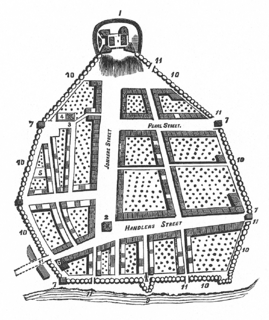
The streets of Albany, New York have had a long history going back almost 400 years. Many of the streets have changed names over the course of time, some have changed names many times. Some streets no longer exist, others have changed course. Some roads existed only on paper. The oldest streets were haphazardly laid out with no overall plan until Simeon De Witt's 1794 street grid plan. The plan had two grids, one west of Eagle Street and the old stockade, and another for the Pastures District south of the old stockade.

General Electric Realty Plot Residential area of Schenectady, New York, originally home to many GE scientists and executives

The General Electric Realty Plot, often referred to locally as the GE Realty Plot, GE Plots or just The Plot, is a residential neighborhood in Schenectady, New York, United States. It is an area of approximately 90 acres (36 ha) just east of Union College.

Woodlawn Preserve

The Woodlawn Preserve is a patch of the Albany Pine Bush in the Woodlawn neighborhood of the city of Schenectady, New York. It is the only remaining example of this rare ecosystem in that area, a combination of swamp, wetlands, water bodies, and dune vegetation, and one of the most biologically diverse parcels in Schenectady County.

Mont Pleasant, Schenectady, New York Neighborhood in Capital District, New York, United States

Mont Pleasant is a neighborhood of Schenectady, New York, United States. It is located in the south central part of the city and is the most populated of Schenectady's neighborhoods and has the most housing units as well.

Bellevue, Schenectady, New York Neighborhood in Capital District, New York, United States

Bellevue is a neighborhood in Schenectady, New York, United States. Within Bellevue is the General Electric (GE) Main Plant, built in 1886 and which was once home to the company headquarters from its formation in the late-19th century until moving to Connecticut in the mid-1970s. Historically many residents walked to work to the GE plant. Bellevue, along with neighboring Mont Pleasant, was annexed by the city of Schenectady in 1903 from the town of Rotterdam.

Downtown Schenectady Neighborhood/Central business district in Capital District, New York, United States

Downtown Schenectady is the central business district for the city of Schenectady, New York. It originated in the 1820s with the moving of the commercial and industrial interests east from the original 17th and 18th century settlement, spurred on by the development of the Erie Canal. Home to the headquarters and major manufacturing plants of two large corporations, General Electric and American Locomotive Company, Downtown Schenectady catered to tens of thousands of workers in its heyday. Typical of the post-industrial Northeastern United States and Upstate New York in particular, Downtown Schenectady saw a decline in manufacturing and population starting in the 1970s. Recent construction and renovation has caused the downtown area to become an entertainment mecca for New York's Capital District anchored by Proctor's Theatre.

References

  1. 1 2 3 Hart, Larry (1985-10-22). "Tales of Old Dorp". Schenectady Gazette. Retrieved 2010-08-23.
  2. Rickards, C.R., ed. (January 1922). "Reports of Divisions: Division of Sanitation- April June". Health News. New York State Department of Health Division of Public Health Education. XVII (1): 166.
  3. "Excelsior Place: Building History". Armida Rose Realty. Retrieved 2010-08-23.
  4. 1 2 3 4 5 6 7 8 9 "City of Schenectady Comprehensive Plan 2020: Woodlawn Neighborhood Plan" (PDF). City of Schenectady, New York.
  5. "City of Schenectady Comprehensive Plan 2010: Citywide Plan" (PDF). City of Schenectady, New York.
  6. 1 2 Lisi, Michael (2007-07-29). "Neighborhoods: Woodlawn". Times Union (Albany). Hearst Corporation. p. I6. Retrieved 2010-08-23.
  7. Goodwin, Mike (2003-07-15). "Plan to Use 'Forever Wild' Draws Fire". Times Union (Albany). Hearst Corporation. p. B8. Retrieved 2010-08-21.