Related Research Articles
The Baptist World Alliance (BWA) is an international Baptist association of Christian churches with an estimated 51 million people in 2023 with 253 member bodies in 130 countries and territories. A voluntary association of Baptist churches, the BWA accounts for about half the Baptists in the world.

Wolvercote is a village in the Oxford district, in the county of Oxfordshire, England. It is about 3 miles (5 km) northwest of the city centre, on the northern edge of Wolvercote Common, which is itself north of Port Meadow and adjoins the River Thames.

Blandford-Blenheim is a township in the Canadian province of Ontario, located in Oxford County. The township had a population of 7,359 in the Canada 2011 Census.

North Oxford is a suburban part of the city of Oxford in England. It was owned for many centuries largely by St John's College, Oxford and many of the area's Victorian houses were initially sold on leasehold by the college.

Banbury Road is a major arterial road in Oxford, England, running from St Giles' at the south end, north towards Banbury through the leafy suburb of North Oxford and Summertown, with its local shopping centre. Parallel and to the west is the Woodstock Road, which it meets at the junction with St Giles'. To the north, Banbury Road meets the Oxford Ring Road at a roundabout. The road is designated the A4165. Prior to the building of the M40 motorway extension in 1990, the road formed part of the A423 from Maidenhead to Coventry.

Summertown in North Oxford is a suburb of Oxford, England. Summertown is a one-mile square residential area, north of St Giles, the boulevard leading out of Oxford's city centre. Summertown is home to several independent schools and the city's most expensive houses. On both sides of Banbury Road are Summertown's popular shops. There is also a smaller street of shops and restaurants, South Parade, that links Banbury Road and Woodstock Road. Summertown is home to much of Oxford's broadcast media. BBC Radio Oxford and the BBC Television's Oxford studios are on Banbury Road. Start-ups also have an increasing presence on the parade, such as Brainomix and Passle. The studios for JACK FM, Glide FM, and Six TV Oxford are on Woodstock Road.

Woodstock Road is a major road in Oxford, England, running from St Giles' in the south, north towards Woodstock through the leafy suburb of North Oxford. To the east is Banbury Road, which it meets at the junction with St Giles'.
Marston Ferry Road is a link road in north Oxford, England. It is named after the ferry that used to cross the River Cherwell at the village of Marston from at least 1279.

Colchester in Essex, England, has a number of notable churches.
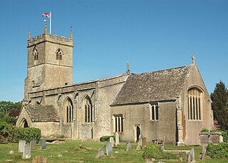
St Laurence's Church, Combe Longa is the Church of England parish church of Combe, Oxfordshire, England. The parish is part of the Benefice of Stonesfield with Combe Longa.

Stanton Harcourt is a village and civil parish in Oxfordshire about 4 miles (6.4 km) southeast of Witney and about 6 miles (10 km) west of Oxford. The parish includes the hamlet of Sutton, 1⁄2 mile (800 m) north of the village. The 2011 Census recorded the parish's population as 960.

St Thomas the Martyr Church is a Church of England parish church of the Anglo-Catholic tradition, in Oxford, England, near Oxford railway station in Osney. It is located between Becket Street to the west and Hollybush Row to the east, with St Thomas Street opposite.

Lathbury Road is a short residential road in north Oxford, England.

Worthing Tabernacle is an independent Evangelical Christian church in the town and borough of Worthing, one of seven local government districts in the English county of West Sussex. The present building, with its distinctive pale stone exterior and large rose window, dates from 1908, but the church was founded in 1895 in a chapel built much earlier in the 19th century during a period when the new seaside resort's population was growing rapidly. In its present form, the church is affiliated with the Fellowship of Independent Evangelical Churches. English Heritage has listed the building at Grade II for its architectural and historical importance.

Horsham Unitarian Church is a Unitarian chapel in Horsham in the English county of West Sussex. It was founded in 1719 to serve the large Baptist population of the ancient market town of Horsham—home of radical preacher Matthew Caffyn—and the surrounding area. The chapel's congregation moved towards Unitarian beliefs in the 19th century, but the simple brick building continued to serve worshippers drawn from a wide area of Sussex. It is one of several places of worship which continue to represent Horsham's centuries-old tradition of Protestant Nonconformism, and is the town's second oldest surviving religious building—only St Mary's, the parish church, predates it. English Heritage has listed the chapel at Grade II for its architectural and historical importance.

Ditchling Unitarian Chapel is a Unitarian chapel in Ditchling, a village in the English county of East Sussex. A congregation of General Baptists began to meet in the 17th century in the village, which was a local centre for Protestant Nonconformist worship, and by the time the present simple Vernacular-style chapel was constructed in 1740 a large proportion of the population held Baptist beliefs. Along with other General Baptist chapels in Sussex, the congregation moved towards Unitarian views in the mid-18th century; this caused a schism which resulted in a new chapel being formed at nearby Wivelsfield. The character of the Ditchling chapel was wholly Unitarian by 1800, and it has continued under various names since then. People associated with the chapel include William Hale White, Henry Acton, Adrian Boult—who was married there—and G. K. Chesterton. The chapel is set back from Ditchling's main street and has an adjoining house and graveyard, all of which contribute to the character of the conservation area which covers the centre of Ditchling village. English Heritage has listed the chapel at Grade II for its architectural and historical importance.

Zoar Strict Baptist Chapel is a Strict Baptist place of worship in the hamlet of Lower Dicker in the English county of East Sussex. Founded in 1837 and originally known as The Dicker Chapel, the "large and impressive" Classical/Georgian-style building stands back from a main road in a rural part of East Sussex. The 800-capacity building included a schoolroom and stables when built, and various links exist between people and pastors associated with the chapel and other Strict Baptist and Calvinistic causes in the county, which is "particularly well endowed with [such] chapels".

Five Ash Down Independent Chapel is an independent Evangelical church in the Reformed (Calvinist) tradition in the hamlet of Five Ash Down, East Sussex, England. Founded in 1773 in the house of a local man, Thomas Dicker Sr. The cause developed so rapidly that a church was founded and a permanent building erected for the congregation 11 years later. The church was run along Calvinistic lines at first, in common with many new chapels in late 18th-century Sussex, and an early group of seceders from the congregation founded a chapel in nearby Uckfield which was run in accordance with Baptist theology. The Five Ash Down chapel has been described as "the parent of many other places [of worship] both Baptist and Independent" across Sussex, and it has continued into the 21st century—now as a small Evangelical fellowship but still worshipping in the original chapel, whose present appearance is a result of expansion and refronting during the Victorian era.

Uckfield Baptist Church is a Baptist congregation based in the town of Uckfield in East Sussex, England. Although services now take place in a school, the cause—founded in 1785 by seceders from the nearby Five Ash Down Independent Chapel—had its own chapel from 1789 until 2005, when the building closed and was sold for residential conversion. The "simple brick chapel" was rebuilt in 1874 and has been listed at Grade II for its architectural and historical importance.