
Tuscaloosa County is a county in the northwest-central portion of the U.S. state of Alabama. As of the 2010 census, its population was 194,656. Its county seat and largest city is Tuscaloosa, the former state capital from 1826 to 1845. The county is named in honor of Tuskaloosa, a paramount chief of the Mississippian culture, who are considered ancestors of the historic Choctaw people of the region.

Tuscaloosa is a city in and the seat of Tuscaloosa County in west central Alabama. Located on the Black Warrior River at the Atlantic Seaboard fall line of the Piedmont, it is the fifth-largest city in Alabama, with an estimated population of 101,129 in 2019. The city was originally known as Tuskaloosa until the early 20th century.

Natural Bridge is a town at the southwest edge of Winston County, Alabama, United States, located near the intersection of U.S. Route 278, Alabama Highway 13, and Alabama State Route 5. It initially incorporated on September 3, 1914. In the 1930s, due to a dwindling population, its charter became dormant. On July 24, 1997 it reincorporated.

U.S. Route 82 is an east–west United States highway in the Southern United States. Created on July 1, 1931 across central Mississippi and southern Arkansas, US 82 eventually became a 1,625-mile (2,615 km) route extending from the White Sands of New Mexico to Georgia's Atlantic coast.

U.S. Route 11 or U.S. Highway 11 is a major north–south United States highway extending 1,645 miles (2,647 km) across the eastern United States. The southern terminus of the route is at U.S. Route 90 in the Bayou Sauvage National Wildlife Refuge in eastern New Orleans, Louisiana. The northern terminus is at the Rouses Point–Lacolle 223 Border Crossing in Rouses Point, New York. The route continues across the border into Canada as Quebec Route 223. US 11, created in 1926, maintains most of the original route.
The Black Warrior River is a waterway in west-central Alabama in the southeastern United States. The river rises in the extreme southern edges of the Appalachian Highlands and flows 178 miles (286 km) to the Tombigbee River, of which the Black Warrior is the primary tributary. The river is named after the Mississippian paramount chief Tuskaloosa, whose name was Muskogean for 'Black Warrior'. The Black Warrior is impounded along nearly its entire course by a series of locks and dams to form a chain of reservoirs that not only provide a path for an inland waterway, but also yield hydroelectric power, drinking water, and industrial water.

U.S. Route 43 (US 43) is a 410-mile-long (660 km) north–south United States Highway in the East South Central States of Alabama and Tennessee. It travels from Prichard, Alabama to Columbia, Tennessee. The highway's southern terminus is in Prichard, at an intersection with US 90. Its northern terminus is in Columbia, Tennessee, at an intersection with US 31/US 412/US 412 Bus.
Central Alabama is the region in the state of Alabama that stretches 170 miles (270 km) from its western border with Mississippi to the eastern border with Georgia and 136 miles (219 km) from the northern border of Cullman County to the Alabama River in southern Autauga County. The region's population was 1,870,970 as of 2008. The Birmingham television market reaches approximately the same area.
The Red River Bridge War was a boundary conflict between the U.S. states of Oklahoma and Texas over an existing toll bridge and a new free bridge crossing the Red River.
Shelton State Community College is a public community college in Tuscaloosa, Alabama. Operated by the Alabama State Department of Postsecondary Education, Shelton is one of the largest two-year colleges in the state. Approximately 4,500 students are enrolled in some form of coursework, including around 3,000 full-time students. The college is currently in good standing with its regional accrediting body SACSCOC.
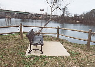
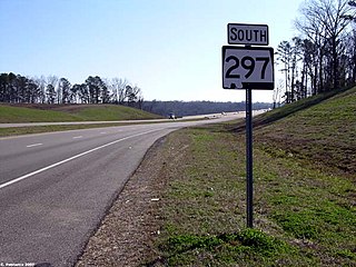
State Route 297 is a short state highway that is just over 1 mile (1.6 km) long highway serving as the fourth Black Warrior River crossing in Tuscaloosa. It acts as a connector between Jack Warner Parkway and Rice Mine Road.
The Paul Bryant Bridge is a four-lane, 150-foot-tall (46 m), $28 million bridge spanning the Black Warrior River along Alabama State Route 297 in Tuscaloosa, Alabama. Construction of the 3,785-foot-long (1,154 m), twin-span bridge commenced in March 2000. Originally slated to open in December 2003, construction delays resulted in its opening on April 23, 2004.
In Alabama, Interstate 20 (I-20) travels 214.7 miles (345.5 km) through the center of the state. It enters the state from Mississippi near Cuba, and travels northeastward through Tuscaloosa and Birmingham. At Birmingham, I-20 turns eastward and heads through Oxford before crossing the Georgia state line near Lebanon. Other cities on the route include Livingston, Bessemer, and Pell City.

The Hugh Rowe Thomas Bridge is a six-lane, girder bridge spanning the Black Warrior River along U.S. Route 43 and Alabama State Route 69, connecting downtown Tuscaloosa and Northport in Tuscaloosa County, Alabama, that opened in 1974. The bridge is split in Tuscaloosa to accommodate two major, one-way thoroughfares, before joining together heading towards Northport. It replaced a lift bridge that was built in 1922 and demolished in 1973.
West Tuscaloosa is a neighborhood located in the western area of Tuscaloosa, Alabama, U.S.A. The area is generally defined as encompassing the portions of the city west of Interstate 359, south of the Black Warrior River and north of the Moody Swamp. This area serves as the location of two higher education facilities, Stillman College and Shelton State Community College.

Alberta City, sometimes shortened as "the ABC" by locals, is the name of a suburban area of Tuscaloosa, Alabama, United States. Alberta City is located in the northeastern portion of Tuscaloosa and is generally defined as encompassing the portions of the city east of U.S. Route 82, west of Holt, south of the Black Warrior River and north of Veterans Memorial Parkway.

The Edmund Pettus Bridge carries U.S. Route 80 Business across the Alabama River in Selma, Alabama. Built in 1940, it is named after Edmund Winston Pettus, a former Confederate brigadier general, U.S. senator, and leader of the Alabama Ku Klux Klan. The bridge is a steel through arch bridge with a central span of 250 feet (76 m). Nine large concrete arches support the bridge and roadway on the east side.

Arcola is a ghost town on the Black Warrior River in what is now Hale County, formerly Marengo County, Alabama. Named to honor the French victory during the Battle of Arcola, it was established in the early 1820s by former French Bonapartists as part of their Vine and Olive Colony, after they were forced to abandon their first town at Demopolis and many found Aigleville unsuitable. The first settler at the site was Frederic Ravesies, who established himself at what later became the Hatch Plantation. Although never more than a village, Arcola became the largest settlement in the colony. Beginning in the 1830s American settlers moved into the area and purchased most of the former French land grants, primarily using Arcola as a river landing. By the 1850s the French settlement had disappeared, replaced by a community of adjoining plantations.
The Birmingham metropolitan area, sometimes known as Greater Birmingham, is a metropolitan area in north central Alabama centered on Birmingham, Alabama.
Black Warrior Brewing Company is a craft brewery in Tuscaloosa, Alabama.
