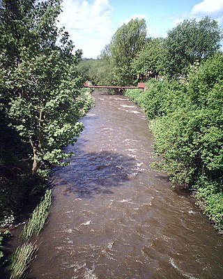
The River Douglas, also known as the River Asland or Astland, flows through parts of Lancashire and Greater Manchester in North West England. It is a tributary of the River Ribble and has several tributaries, the major ones being the River Tawd and the River Yarrow.

East Bay Municipal Utility District (EBMUD), colloquially referred to as "East Bay Mud", is a public utility district which provides water and sewage treatment services for an area of approximately 331 square miles (860 km2) in the eastern side of the San Francisco Bay. As of 2018, EBMUD provides drinking water for approximately 1.4 million people in portions of Alameda County and Contra Costa County in California, including the cities of Richmond, El Cerrito, Hercules, San Pablo, Pinole, Lafayette, Moraga, Orinda, Danville, Oakland, Piedmont, Emeryville, Berkeley, Albany, Alameda, San Leandro, neighboring unincorporated regions, and portions of cities such as Hayward and San Ramon. Sewage treatment services are provided for 685,000 people in an 88-square-mile area (as of 2018). EBMUD currently has an average annual growth rate of 0.8% and is projected to serve 1.6 million people by 2030. Headquartered in Oakland, EBMUD owns and maintains 2 water storage reservoirs on the Mokelumne River, 5 terminal reservoirs, 91 miles (146 km) of water transmission aqueducts, 4,100 miles (6,600 km) of water mains, 6 water treatment plants (WTPs), 29 miles (47 km) of wastewater interceptor sewer lines and a regional wastewater treatment facility (WWTF) rated at a maximum treatment capacity of 320 MGD.

Lake Vyrnwy is a reservoir in Powys, Wales, built in the 1880s for Liverpool Corporation Waterworks to supply Liverpool with fresh water. It flooded the head of the Vyrnwy valley and submerged the village of Llanwddyn.

Perry Barr Reservoir is a covered drinking water reservoir, in north Birmingham, England, operated by Severn Trent Water. Built for the then Birmingham Corporation Water Department, on the site of the former Perry Barr Farm, it is not, despite its name, in the modern Perry Barr area, but nearby Kingstanding, at grid reference SP083951.
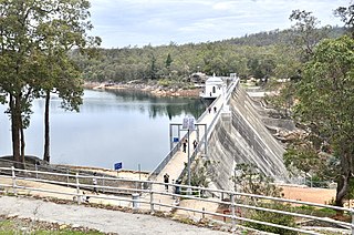
Mundaring Weir is a concrete gravity dam located 39 kilometres (24 mi) from Perth, Western Australia in the Darling Scarp. The dam and reservoir form the boundary between the suburbs of Reservoir and Sawyers Valley. The dam impounds the Helena River.
Worthington is a civil parish within the Metropolitan Borough of Wigan, in Greater Manchester, England, about four miles (6.4 km) north of Wigan. The parish is very sparsely populated, at the 2001 census having a population of 135, and does not have an active parish council or parish meeting.

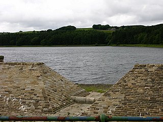
Anglezarke Reservoir is the largest reservoir in the Rivington chain to the west of Anglezarke in Lancashire, England. Anglezarke Reservoir has three embankments: the Charnock Embankment, the longest, is 850 yards (777 m) long and 31 feet (9.45 m) high, the Knowsley Embankment is 240 yards (219.5 m) long and 45 feet (14 m) high and the Heapey Embankment is 280 feet (85.3 m) long and 32 feet (9.75 m) high. It is fed by the River Yarrow, which has been diverted from its original course which is now covered by the Knowsley Embankment. It served the city of Liverpool before its current status as a supply mainly for Wigan. The original `Rivington Pike Scheme' was undertaken by Thomas Hawksley between 1850 and 1857 for the Liverpool Corporation Waterworks. The scheme was to construct five reservoirs and a water treatment works at the south end of Lower Rivington with a 17-mile (27 km) pipeline to storage reservoirs at Prescot. Water from two higher level reservoirs, Rake Brook and Lower Roddlesworth, was carried south in `The Goit', a channel connecting them to the reservoirs.

Rivington Water Treatment Works is a water treatment plant in Rivington, Lancashire, England. It is located below the Lower Rivington Reservoir, the last in the Rivington chain of reservoirs. The first treatment works, a slow-sand filter plant on the site opened in 1860, supplying water to Liverpool. The present works was built in 1994, and in 2007 was the largest automated three-stage plant operated by United Utilities, the water is now disinfected by adding small amounts of chlorine. Most of its output supplies customers in the Wigan area.
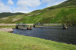
Lower Rivington Reservoir is at the end of the Rivington chain of reservoirs in Lancashire, England, with Upper Rivington Reservoir to the north, and Rivington Water Treatment Works to the south. The Rivington chain primarily supplies 70,000 households in the Wigan area. The chain was built to supply Liverpool.

The Prospect Reservoir is a heritage-listed 50,200-megalitre potable water supply and storage reservoir created by the Prospect Dam, across the Prospect Creek located in the Western Sydney suburb of Prospect, in New South Wales, Australia. The eastern bounds of the reservoir are a recreational area and the western periphery are within the bounds of Western Sydney Parklands. It was added to the New South Wales State Heritage Register on 18 November 1999.

Arnfield Reservoir is a man-made lake in Longdendale in north Derbyshire. It was constructed in 1854 as part of the Longdendale chain to supply water from the River Etherow to the urban areas of Greater Manchester. Unlike the other reservoirs in the chain, Arnfield and Hollingworth Reservoir are not in the Etherow valley but lie in the valley of tributary brooks to the north and above. From Arnfield the water is extracted to pass through the Mottram Tunnel to Godley.

The Sulby Reservoir is the largest reservoir or lake in the Isle of Man, with an area of 154 acres (62 ha).

The Staines Reservoirs are two large pumped storage reservoirs sitting to the east of the King George VI Reservoir near Heathrow airport in Surrey within the Colne Valley regional park. The village of Stanwell is mainly to the north east, and the town of Staines is to the south.

Split Rock Dam is a minor ungated concrete faced rock fill embankment dam with concrete chute spillway across the Manilla River upstream of Manilla in the north-western slopes region of New South Wales, Australia. The dam's purpose includes flood mitigation, irrigation, water supply and conservation. The impounded reservoir is called Split Rock Reservoir.

Walka Water Works is a heritage-listed 19th-century pumping station at 55 Scobies Lane, Oakhampton Heights, City of Maitland, New South Wales, Australia. Originally built in 1887 to supply water to Newcastle and the lower Hunter Valley, it has since been restored and preserved and is part of Maitland City Council's Walka Recreation and Wildlife Reserve. It was added to the New South Wales State Heritage Register on 2 April 1999.

Spring Creek Debris Dam is an earthfill dam on Spring Creek, a tributary of the Sacramento River, in Shasta County in the U.S. state of California. Completed in 1963, the dam, maintained by the U.S. Bureau of Reclamation, serves primarily to collect severe acid mine drainage stemming from the Iron Mountain Mine. The dam forms the Spring Creek Reservoir, less than 1 mile (1.6 km) long. Spring Creek and South Fork Spring Creek flow into the reservoir from a 16-square-mile (41 km2) watershed. The dam is directly upstream from the city of Keswick, California and the Keswick Reservoir. The operation is part of the Trinity River Division of the Central Valley Project.
Turton and Entwistle Reservoir is a water reservoir in the village of Edgworth, Lancashire, England. The reservoir's existence is due to the Entwistle Dam. When constructed in 1832 the Entwistle Dam was the highest in Britain; it rises 108 feet from the base. The reservoir contains almost 750 thousand imperial gallons and, with the Wayoh Reservoir just below, satisfies around 50% of Bolton's need for drinking water.

Rivelin Dams are a pair of water storage reservoirs situated in the upper part of the Rivelin Valley, 5 miles (8 km) west of Sheffield in South Yorkshire, England. The dams are owned by Yorkshire Water and provide water to 319,000 people as well as compensation water for the River Rivelin. They are named Upper and Lower and fall just within the eastern boundary of the Peak District.
Edinburgh Water Company and its successors have provided a public water supply and latterly sewerage and sewage treatment services to the Scottish capital of Edinburgh since 1819. The original company was established to supply drinking water and did so until 1870, when it was taken over by a public Water Trust, with representatives from Edinburgh, Leith and Portobello. That in turn was taken over by Edinburgh Corporation and in 1975, responsibility passed to the Lothian Regional Council, as did the duty to provide sewerage and sewage treatment services. Both services were moved out of local authority control, and taken over by the East of Scotland Water Authority in 1996. The three Scottish regional water authorities were merged to form Scottish Water in 2002.
The Mourne Conduit was a water main which ran 42 kilometres (26 mi) from the Silent Valley Reservoir to Carryduff, near Belfast and was built between 1893 and 1901 for the Belfast City and District Water Commissioners. This was supplemented by additional pipelines twice in the 20th Century. This system supplied water to Greater Belfast and North Down for more than 100 years. It is labelled as the Mourne Aqueduct in Ordnance Survey maps from the early 20th century.

