Wouw

Last updated
Wouw
Village
RoosendaalsestraatWouw.JPG
Roosendaalsestraat in Wouw
Flag of wouw.png
Wouw wapen.svg
LocatieRoosendaal.png
2010-NL-P10-Noord-Brabant-positiekaart-gemnamen.jpg
Red pog.svg
Wouw
Location in the province of North Brabant in the Netherlands
Netherlands location map.svg
Red pog.svg
Wouw
Wouw (Netherlands)
Coordinates: 51°31′20″N4°23′20″E / 51.52222°N 4.38889°E / 51.52222; 4.38889
Country Netherlands
Province North Brabant
Municipality Roosendaal
Area
[1]
  Total8.82 km2 (3.41 sq mi)
Elevation
[2]
6 m (20 ft)
Population
 (2021) [1]
  Total4,795
  Density540/km2 (1,400/sq mi)
Time zone UTC+1 (CET)
  Summer (DST) UTC+2 (CEST)
Postal code
4724 [1]
Dialing code 0165

Wouw is a village in the southern Netherlands. It is located in North Brabant, between the cities Roosendaal and Bergen op Zoom, close to the border with Belgium.

Contents

Until 1997 Wouw was the seat of the municipality of Wouw. The municipality consisted of the villages of Wouw, Heerle, Wouwse Plantage and Moerstraten. In 1997 Wouw was merged into the municipality of Roosendaal en Nispen, the resulting enlarged municipality becoming known simply as Roosendaal.

In 2007 Wouw celebrated its 775th anniversary.

History

The origins of Wouw probably go back to around 1200 which is when exploitation of the local woodland began to occur. The evolution from woodland clearing to village progressed relatively rapidly during the high Middle Ages, with mention of a church in 1277, and the establishment of the parish in 1304. The first surviving record of the moated castle, built by the Lords of Bergen op Zoom, dates from 1342.

In 2007, Wouw celebrated its 775th year of existence.
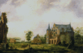
The castle of Wouw

Between Wouw and Heerle there used to be a castle. This castle is first mentioned in 1379 as "Het Huis te Woude", which means: The House in Woude. (Woude=Wouw). It was a round castle surrounded by a body of water. This provided protection to its lord and its inhabitants.

The grounds outside the castle were very fertile, and many farms were to be found there. The lord could see and thus supervise all the farmers' grounds from his castle. The lord also had a military role. For example, he fought in several battles.

After the invention of gunpowder the inhabitants of the castle would no longer be safe. The castle therefore became one of the first castles to be strengthened by fortifications. During the Eighty Years' War the castle was captured several times. As a consequence the inhabitants eventually fled. The castle was inhabited from 1583 till 1594. Since then the castle has had many uses but eventually it slowly vanished.

Nowadays nothing much can be seen of the castle. Plants have been planted marking parts of the foundations of the castle, so the positions of some of the buildings can still be inferred.

Related Research Articles

<span class="mw-page-title-main">Roosendaal</span> Municipality in North Brabant, Netherlands

Roosendaal is both a city and a municipality in the southern Netherlands, in the province of North Brabant.

<span class="mw-page-title-main">Bergen op Zoom</span> City and municipality in North Brabant, Netherlands

Bergen op Zoom is a city and municipality in the Southwestern Netherlands. It is located in the province of North Brabant, at the provincial border with Zeeland. In January 2021, the municipality had a population of 67,514.

<span class="mw-page-title-main">Sint-Maartensdijk</span> Village in Zeeland, Netherlands

Sint-Maartensdijk is a village in the Dutch province of Zeeland. It is a part of the municipality of Tholen, and lies about 16 km west of Bergen op Zoom.

<span class="mw-page-title-main">Stavenisse</span> Village in Zeeland, Netherlands

Stavenisse is a village in the Dutch province of Zeeland. It is a part of the municipality of Tholen, and lies about 22 kilometres (14 mi) west of Bergen op Zoom.

<span class="mw-page-title-main">Sint Jansteen</span> Village in Zeeland, Netherlands

Sint Jansteen is a village in the Dutch province of Zeeland. It is a part of the municipality of Hulst, and lies about 31 km southwest of Bergen op Zoom.

<span class="mw-page-title-main">Clinge</span> Village in Zeeland, Netherlands

Clinge is a village in the Dutch province of Zeeland. It is a part of the municipality of Hulst, and lies about 28 km southwest of Bergen op Zoom. Clinge is located on the Dutch-Belgian border and joins with the Belgian town of De Klinge, in the Belgian municipality of Sint-Gillis-Waas. This border can normally be crossed freely.

<span class="mw-page-title-main">Graauw</span> Village in Zeeland, Netherlands

Graauw is a village in the Dutch province of Zeeland. It is a part of the municipality of Hulst, and lies about 22 km southwest of Bergen op Zoom.

<span class="mw-page-title-main">Paal, Netherlands</span> Hamlet in Zeeland, Netherlands

Paal is a hamlet in the southwest Netherlands. It is a part of the municipality of Hulst, Zeeland, and is located 35 km north of Antwerp, Belgium.

<span class="mw-page-title-main">Heikant, Zeeland</span> Village in Zeeland, Netherlands

Heikant is a village in the Dutch province of Zeeland. It is a part of the municipality of Hulst, and lies about 33 km southwest of Bergen op Zoom.

<span class="mw-page-title-main">Lamswaarde</span> Village in Zeeland, Netherlands

Lamswaarde is a village in the Dutch province of Zeeland. It is a part of the municipality of Hulst, and lies about 23 km southwest of Bergen op Zoom.

<span class="mw-page-title-main">Zegge</span> Village in North Brabant, Netherlands

Zegge is a village located in the municipality of Rucphen, North Brabant in the Netherlands. On 1 January 2020, the village had 2,045 inhabitants. Viewed from the four other villages in the municipality of Rucphen, Zegge is located on the other side of the A58 motorway. This combined with its small size, makes it so that much of the daily life of its inhabitants centers around the nearby city of Roosendaal.

<span class="mw-page-title-main">Siege of Bergen op Zoom (1588)</span>

The siege of Bergen op Zoom was a siege that took place during the Eighty Years' War and the Anglo–Spanish War between September 23 - November 13, 1588. The siege took place in the aftermath of the Spanish Armada where under famed commander Alexander Farnese, the Duke of Parma attempted to use his forces utilised for the invasion of England to besiege Bergen op Zoom which was held by an Anglo-Dutch force under Thomas Morgan and Peregrine Bertie. An English officer Grimstone claimed to be a disaffected Catholic, had set up a trap during which a large Spanish assault was then bloodily repulsed. An Anglo-Dutch relief column under the command Maurice of Orange soon after arrived and forced the Duke of Parma to retreat, thus ending the siege.

<span class="mw-page-title-main">Bath, Netherlands</span> Village in Zeeland, Netherlands

Bath is a small village and a former municipality in the Dutch province of Zeeland, lying on the north shore of the Western Scheldt. It is now located in the municipality of Reimerswaal, about 10 km southwest of Bergen op Zoom.

<span class="mw-page-title-main">Halsteren</span> Town in North Brabant, Netherlands

Halsteren is a town in the Dutch province of North Brabant. It is located in the municipality of Bergen op Zoom, about 1 km north of that city. Halsteren has an old church from the 14th century and a new church, built in 1919. A little village called Polder was located between Halsteren and Tholen in the Middle Ages.

Roosendaal en Nispen was a municipality in the Dutch province of North Brabant. It included the villages of Roosendaal and Nispen.

<span class="mw-page-title-main">Heerle</span> Village in North Brabant, Netherlands

Heerle is a village in the municipality of Roosendaal, in the Dutch province of North Brabant. Before the municipal reorganisation of 1997, Heerle was part of the municipality of Wouw. It lies between the cities of Bergen op Zoom and Roosendaal.

<span class="mw-page-title-main">Biezelinge</span> Neighbourhood and former village in Kapelle, Zeeland, Netherlands

Biezelinge is a neighbourhood of Kapelle and former village in the Dutch municipality of Kapelle.

<span class="mw-page-title-main">Hoogerheide</span> Village in North Brabant, Netherlands

Hoogerheide is a village in the municipality of Woensdrecht, North Brabant, Netherlands. The name "Hoogerheide" means "High Heath" in English. The Grand Prix Adri van der Poel cyclo-cross race is held annually in Hoogerheide.

<span class="mw-page-title-main">Battle of Steenbergen (1583)</span>

The Battle of Steenbergen, also known as the Capture of Steenbergen of 1583, took place on 17 June 1583 at Steenbergen, Duchy of Brabant, Spanish Netherlands. This was an important victory for the Spanish Army of Flanders led by Don Alexander Farnese, Prince of Parma, Governor-General of the Spanish Netherlands, over the French, English, and Dutch forces led by the French Marshal Armand de Gontaut, Baron de Biron, and the English commander Sir John Norreys, during the Eighty Years' War, the Anglo-Spanish War (1585–1604), and in the context of the French Wars of Religion. The victory of the Spaniards ended the Treaty of Plessis-les-Tours, and Francis, Duke of Anjou (French: François de France), left the Netherlands in late June.

<span class="mw-page-title-main">Nispen</span> Town in North Brabant, Netherlands

Nispen is a town in the Dutch province of North Brabant. It is part of the municipality of Roosendaal, formerly the municipality of Roosendaal en Nispen.

References

  1. 1 2 3 "Kerncijfers wijken en buurten 2021". Central Bureau of Statistics. Retrieved 18 April 2022.
  2. "Postcodetool for 4724AA". Actueel Hoogtebestand Nederland (in Dutch). Het Waterschapshuis. Retrieved 18 April 2022.