Wreck of the Ephraim Williams

Last updated
A surboat, like those used to rescue the Ephraim Williams crew, would be towed on a cart like this one, to a suitable launching spot, where she would be pushed into the water deep enough to float her off the cart. Crew members tow a US Lifeboat Service Surfboat mounted a special launching cart -a.jpg
A surboat, like those used to rescue the Ephraim Williams crew, would be towed on a cart like this one, to a suitable launching spot, where she would be pushed into the water deep enough to float her off the cart.

The Ephraim Williams was a sailing ship wrecked off the coast of Hatteras Island, North Carolina, during a late December storm, late in 1884. [1] [2] [3] [4] [5] [6] [7] The rescue of the barkentine's crew by Benjamin B. Dailey and his six oarsmen of the United States Lifesaving Service was considered particularly heroic, and the rescue is celebrated to the present day.

The 491-ton vessel's homeport was Providence, Rhode Island. [8] She was returning there with a load of timber from Savannah, Georgia, when she became waterlogged and unmanageable on December 18, 1884, off Frying Pan Shoals. The vessel became visible to staff at four lifesaving stations on December 21. Heavy surf made launching a rescue boat extremely hazardous. Only the waterlogged wreck's masts were visible. Lifesaving staff couldn't tell whether there were any survivors to try to rescue. The vessel was seen again on the morning of December 22, off Diamond Shoal.

Cape Hatteras is the easternmost tip of a chain of barrier islands. [8] Off the beach are an inner and outer sandbank. The difficulty in crossing the outer sandbank increases with the size of the waves.

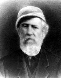
When the Ephraim Williams crew raised a distress flag, shortly before 10:30 am, confirming there were survivors onboard who needed rescue, surfboats from several stations launched to attempt a rescue. [8] The second in command of Dailey's lifeboat stated that his wife was dying at home, and he had no wish to make his children orphans. Patrick H. Etheridge, the keeper of the nearby Creed's Hill Lifesaving Station quickly volunteered to take his place.

The crew of the rescue surfboat of the Cape Hatteras Lifesaving Station proved it was possible to cross the sandbank, during heavy weather, with precise timing, and extreme effort, in order cross the bar at the height of a wave. With enough effort they proved a skilled and determined crew could cross over the bar before it was swept by the next trough. The crews of the other surfboats were unable to cross the outer bar.

The surfboat's crew then rowed five miles to the distressed vessel. [8] Crew members had to board the stricken vessel and bodily carry some of the exhausted crew to the boat. Dailey and Etheridge switched roles, and Etheridge guided the boat during the dangerous return to shore. Observers described the waves that day as the worst they had ever seen, and described their concern that the rescuers themselves would lose their lives.

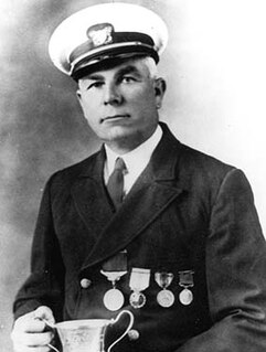
The officer that recommended the crew receive the US Coast Guard Gold Lifesaving Medal wrote:

I do not believe that a greater act of heroism is recorded than that of Dailey and his crew on this momentous occasion. These poor, plain men, dwellers upon the lonely sands of Hatteras, took their lives in their hands and, at the most imminent risk, crossed the most tumultuous sea that any boat within the memory of living men had ever attempted on that bleak coast, and all for what. That others might live to see home and friends. The thought of reward or mercenary appeal never once entered their minds. Duty, their sense of obligation, and the credit of the Service impelled them to do their mighty best. The names of Benjamin B. Dailey and his comrades in this magnificent feat should never be forgotten. As long as the Life-Saving Service has the good fortune to number among its keepers and crews such men as these, no fear need ever be entertained for its good name or purposes.

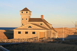
David Stick, the author of Graveyard of the Atlantic: Shipwrecks of the North Carolina Coast, noted that: "During the first thirty years of operation of the Lifesaving Service on the North Carolina coast a total of twelve Gold Lifesaving Medals, the highest such award made by our government, were presented for exceptional bravery in saving life." [8] Of this number, seven—more than half—were awarded to the lifesavers from Cape Hatteras and Creed's Hill stations who rescued the crew of the barkentine Ephraim Williams, December 22, 1884. Dailey's crew consisted of oarsmen Isaac L. Jennett, Thomas Gray, John H. Midgett, Jabez B. Jennett, and Patrick H. Etheridge, the station keeper at nearby Creed's Hill, who was filling in for an absent oarsman. Dailey's medal remains on display at the Cape Hatteras National Seashore's Hatteras Island Visitor Center and Museum of the Sea. [9]

Related Research Articles

Cape Hatteras Lighthouse Lighthouse in North Carolina, United States

Cape Hatteras Light is a lighthouse located on Hatteras Island in the Outer Banks in the town of Buxton, North Carolina and is part of the Cape Hatteras National Seashore. The lighthouse’s semi-unique pattern makes it easy to recognize and famous. It is often ranked high on lists of most beautiful, and famous lighthouses in the US.

Lifesaving Medal US decoration from the Coast Guard

The Gold Lifesaving Medal and Silver Lifesaving Medal are U.S. decorations issued by the United States Coast Guard. The awards were established by Act of Congress, 20 June 1874; later authorized by 14 U.S.C. § 500. These decorations are two of the oldest medals in the United States and were originally established at the Department of Treasury as Lifesaving Medals First and Second Class. The Department of the Treasury initially gave the award, but today the United States Coast Guard awards it through the Department of Homeland Security. They are not classified as military decorations, and may be awarded to any person.

Bodie Island Lighthouse Lighthouse in North Carolina, United States

The current Bodie Island Lighthouse is the third that has stood in this vicinity of Bodie Island on the Outer Banks in North Carolina and was built in 1872. It stands 156 feet (48 m) tall and is located on the Roanoke Sound side of a portion of a peninsula that is the first part of the Cape Hatteras National Seashore. The lighthouse is just south of Nags Head, a few miles before Oregon Inlet. It was renovated from August 2009 to March 2013, and was made climbable by the public. There are 214 steps that spiral to the top. The 170-foot structure is one of only a dozen remaining tall, brick tower lighthouses in the United States — and one of the few with an original first-order Fresnel lens to cast its light.

United States Life-Saving Service Precursor to the U.S. Coast Guard

The United States Life-Saving Service was a United States government agency that grew out of private and local humanitarian efforts to save the lives of shipwrecked mariners and passengers. It began in 1848 and ultimately merged with the Revenue Cutter Service to form the United States Coast Guard in 1915.

<i>Carroll A. Deering</i>

Carroll A. Deering was a five-masted commercial schooner that was found run aground off Cape Hatteras, North Carolina in 1921 with the crew nowhere to be found. The Deering is one of the most written-about maritime mysteries in history, with claims that it was a victim of the Bermuda Triangle, though no evidence of paranormal or supernatural events aboard the ship has ever surfaced.

Cape Hatteras National Seashore

Cape Hatteras National Seashore is a United States national seashore which preserves the portion of the Outer Banks of North Carolina from Bodie Island to Ocracoke Island, stretching over 70 miles (110 km), and is managed by the National Park Service. Included within this section of barrier islands along N.C. 12, but outside the national seashore boundaries, are Pea Island National Wildlife Refuge and several communities, such as Rodanthe, Buxton, and Ocracoke. Cape Hatteras is a combination of natural and cultural resources, and provides a wide variety of recreational opportunities.

Virginia Beach Surf & Rescue Museum United States historic place

The Virginia Beach Surf & Rescue Museum honors and preserves the history of Virginia's maritime heritage, coastal communities, the United States Lifesaving Service, and the United States Coast Guard along the Atlantic coast.

Cape Lookout Lighthouse

The Cape Lookout Lighthouse is a 163-foot-high lighthouse located on the southern Outer Banks of North Carolina. It flashes every 15 seconds and is visible at least 12 miles out to sea and up to 19 miles. It is one of the very few lighthouses that operate during the day. It became fully automated in 1950. The Cape Lookout Lighthouse is the only such structure in the United States to bear the checkered daymark, intended not only for differentiation between similar light towers, but also to show direction. The center of the black diamonds points in a north-south direction, while the center of the white diamonds points east-west.

Oregon Inlet is an inlet along North Carolina's Outer Banks. It joins the Pamlico Sound with the Atlantic Ocean and separates Bodie Island from Pea Island, which are connected by the 2.8 mile Marc Basnight Bridge that spans the inlet. As one of the few access points to the ocean along this stretch of coast, Oregon Inlet is a major departure point for charter fishing trips, with a nearby harbor serving as the base for many large boats that travel miles out towards the Gulf Stream almost every day. The inlet is also the location of a U.S. Coast Guard motor lifeboat station.

Rasmus S. Midgett (1851–1926) was a United States Life-Saving Service surfman in North Carolina who single-handedly rescued ten men from the sinking barkentine Priscilla and was thereafter awarded the Gold Lifesaving Medal from the Secretary of the Treasury on October 18, 1899.

Joshua James (lifesaver)

Joshua James was an American sea captain and a U.S. Life–Saving Station keeper. He was a famous and celebrated commander of civilian life-saving crews in the 19th century, credited with saving over 500 lives from the age of about 15 when he first associated himself with the Massachusetts Humane Society until his death at the age of 75 while on duty with the United States Life–Saving Service. During his lifetime he was honored with the highest medals of the Humane Society and the United States. His father, mother, brothers, wife, and son were also lifesavers in their own right.

Pea Island Life-Saving Station

Pea Island Life-Saving Station was a life-saving station on Pea Island, on the Outer Banks of North Carolina. It was the first life-saving station in the country to have an all-black crew, and it was the first in the nation to have a black man, Richard Etheridge, as commanding officer. On August 3, 2012, the second of the Coast Guard's 154-foot Sentinel-Class Cutters, USCGC Richard Etheridge (WPC-1102), was commissioned in his honor.

Old Harbor U.S. Life Saving Station

The Old Harbor U.S. Life Saving Station is a historic maritime rescue station and museum, located at Race Point Beach in Provincetown, Massachusetts. Built in 1897, it was originally located at Nauset Beach near the entrance to Chatham Harbor in Chatham, Massachusetts. It was used by the United States Life-Saving Service (USLSS), and then by its successor, the United States Coast Guard (USCG), as the Old Harbor Coast Guard Station. The station was decommissioned in 1944, abandoned and sold as surplus in 1947, and was used as a private residence for the next twenty-six years.

Bodie Island Lifesaving and Coast Guard Station United States historic place

The Bodie Island Lifesaving Station, also known as the Bodie Island Coast Guard Station, is located on the Outer Banks of North Carolina at the southern end of Bodie Island, within Cape Hatteras National Seashore. The 10-acre (4.0 ha) district includes a residence, the lifesaving station, the Coast Guard station, and an observation tower, as well as a number of utility buildings. The facility was turned over to the National Park Service in 1953, with the establishment of the national seashore. The primary structure, the lifesaving station, was built in 1878, and was converted to a residence when the Coast Guard station was built in 1925. It was moved to its present location in 1955, as it was threatened by shoreline erosion. The Coast Guard station was altered the same year to provide housing and office space for the National Park Service.

USCGC <i>Richard Etheridge</i>

USCGC Richard Etheridge is the second of the United States Coast Guard's Sentinel-class cutters. Like most of her sister ships she replaced a 110-foot (34 m) Island-class patrol boat. Richard Etheridge was launched in August 2011.

John Allen Midgett Jr. United States Coast Guard officer

John Allen Midgett Jr. was a senior enlisted member of first the United States Life-Saving Service, and later the United States Coast Guard.

Benjamin B. Dailey

Benjamin Baxter Dailey was the keeper of several lifeboat stations for the United States Life-Saving Service—one of the precursor services to the United States Coast Guard.

USCGC <i>Winslow W. Griesser</i>

USCGC Winslow Griesser (WPC-1116) was the sixteenth Sentinel-class cutter to be delivered. She will be the fourth of six Sentinel-class vessels to be stationed in San Juan, Puerto Rico. Bollinger shipyards delivered her to the United States Coast Guard, in Key West, Florida, on December 23, 2015. After she completed her acceptance trials, she was commissioned on March 11, 2016.

Bailey Taylor Barco was a heroic stationkeeper and Captain with the United States Life-Saving Service—one of the agencies later merged into the United States Coast Guard. He led a heroic rescue at his station in Virginia Beach, on December 21, 1900.

USCGC <i>Benjamin B. Dailey</i>

USCGC Benjamin Dailey (WPC-1123) is the United States Coast Guard's 23rd Sentinel-class cutter. She is the first cutter of her class stationed in the Coast Guard's Eight District, with a homeport in Pascagoula, MS.

References

  1. "Ephraim Williams Rescue". Coast Guide. Archived from the original on 2014-08-28. Out of Providence, RI the vessel was bound home from Savannah, GA with a cargo of pine lumber. On 18 December, when to the northward of Frying Pan Shoals, she encountered heavy weather and became waterlogged and almost a complete wreck. In this condition she drifted helplessly before the southerly gale until near Cape Hatteras.
  2. "Who are some of the heroes of the Coast Guard?". USCG. 2014-08-26. Archived from the original on 2014-08-27.
  3. Christopher Havern (2014-01-23). "Benjamin B. Dailey". USCG. Archived from the original on 2014-08-28.
  4. "Rowboats to choppers, tales of rescue at sea". Life magazine. 1967-07-15. p. 50. Retrieved 2014-08-27.
  5. "Two Tales of Bravery from the U.S. Life-Saving Service". Carolina Outer Banks. Archived from the original on 2014-08-28. Retrieved 2014-08-27. The other crews knew it was hopeless, sure the surfboat could not make it over the treacherous outer sandbar with the sea conditions that existed that day. But luck and skill prevailed, and the small boat somehow made it across.
  6. "Hatteras Island Lifesaving Stations". North Caroline Beaches. Archived from the original on 2014-08-27.
  7. "The U.S. Lifesaving Service". National Park Service. Archived from the original on 2014-07-15. Retrieved 2014-08-27. Cape Hatteras National Seashore preserves the history of the U.S. Lifesaving Service on the Outer Banks. Walk the same beaches that Rasmus Midgett once patrolled or stop and see what Keeper Dailey’s medal looks like at the Museum of the Sea near the Cape Hatteras Lighthouse.
  8. 1 2 3 4 5 David Stick (1989). "Graveyard of the Atlantic: Shipwrecks of the North Carolina Coast". University of North Carolina Press. pp. 111–115. ISBN   9780807842614 . Retrieved 2014-08-28. The Ephraim Williams, a 491-ton vessel loaded with lumber and bound from Savannah, Georgia, to her home port of Providence, Rhode Island, with a crew of nine, ran into a storm off Frying Pan Shoals December 18 and soon became waterlogged and unmanageable.
  9. "Visitor Centers". Cape Hatteras National Seashore. Retrieved 14 September 2014.

Coordinates: 35°18′14″N75°30′37″W / 35.30391°N 75.51023°W / 35.30391; -75.51023