Wrigley, Long Beach

Last updated
Wrigley, California
Wrigley Long Beach California.jpg
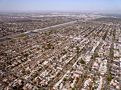
The Wrigley neighborhood of Long Beach, California. Willow Street runs from the right side of the photo, through the center of the neighborhood, to the bridge crossing the Los Angeles River on the left.
Country Flag of the United States.svg United States
State Flag of California.svg  California
County Flag of Los Angeles County, California.svg Los Angeles
City Flag of Long Beach, California.png Long Beach

Wrigley is a group of neighborhoods in Long Beach, California. It includes the neighborhoods North Wrigley, South Wrigley, Southeast Wrigley and Wrigley Heights. [1] Its name derives from William Wrigley Jr., the owner and founder of the famed Wrigley Spearmint Gum Empire in Chicago. It was one of the first communities established in Long Beach. With the exception of Wrigley Heights, the area is developed throughout on a gridiron street pattern.[ citation needed ]

Contents

The district is bounded on the north by Interstate 405, on the south by Pacific Coast Highway, on the east by Long Beach Boulevard and on the west by the Los Angeles River. Pacific Avenue also goes through the area with commercial strip land uses. The Los Angeles River and the Interstate 710 make up the western boundary.[ citation needed ]

The neighborhood has a community park, Veterans Park, [2] convenient access to local freeways, A Line light rail transportation and the new Wrigley Marketplace shopping district - an innovative joint venture between Long Beach and the Metropolitan Transportation Authority. The center combines neighborhood-serving retail with a modern park and ride facility for light rail commuters.[ citation needed ]

History

The original subdivision pattern was established in 1905. Homes on 48 lots were developed by William Wrigley's company between 1928 and 1934. These blocks of homes now form the Wrigley Landmark District. [3]

In 1914, George Encinas purchased six and one-half acres of land from the Bixby family to establish the Encinas family ranch. The ranch house at 625 Baker Street was demolished in 1960 during the development of Interstate 405. [4] The Baker Street Park was established in 2011 at the address of the former ranch house. [5]

Homes in Wrigley Heights were developed by Lloyd Whaley. [6]

Architecture

See also

Related Research Articles

Gateway Cities Region of Los Angeles County, California, US

The Gateway Cities Region, or Southeast Los Angeles County is an urbanized region located in southeastern Los Angeles County, California, between the City of Los Angeles proper, Orange County, and the Pacific Ocean. The cluster of cities has been termed "Gateway Cities" in that they serve as a "gateway" between the LA and Orange counties, with the city of Cerritos equidistant from downtown LA, Long Beach, and the center of Orange County. As such, the area is central to the Los Angeles-Long Beach-Anaheim, CA Metropolitan Statistical Area (MSA), and has a population of approximately 2,000,000 residents.

Downtown Long Beach Neighborhood of Long Beach in Los Angeles, California, United States

Downtown Long Beach is the heart of Long Beach, California, United States, and is the location for most of the city's major tourist attractions and municipal services. It is also the location for numerous businesses. There are many hotels and restaurants in the area that serve locals, tourists, and convention visitors.

Belmont Heights, Long Beach, California Neighborhood of Long Beach in Los Angeles, California, United States

Belmont Heights is a district in the south-east portion of the city of Long Beach, California, United States, bordering the Pacific Ocean and the more commercial community of Belmont Shore. The district commemorates the old City of Belmont Heights, which was incorporated in 1908 and annexed to Long Beach in 1909. Belmont Heights' borders are Ocean Boulevard and Livingston Drive to the south, Redondo Avenue on the west, 7th Street to the North, and Nieto Avenue to the east. The area is mostly residential, but also has an active business district, the strip of Broadway east of Redondo Avenue.

West Long Beach

West Long Beach is a working-class neighborhood in Long Beach, California.

Bixby Knolls is a neighborhood in Long Beach, California.

California Heights is a historic neighborhood of Long Beach, California.

Rose Park, Long Beach, California

Rose Park and Rose Park South are two neighborhoods in Long Beach, California.

Long Beach Police Department (California)

The Long Beach Police Department provides law enforcement for the city of Long Beach, California.

Los Altos is a residential neighborhood located in eastern Long Beach.

Alamitos Beach, Long Beach, California Neighborhood of Long Beach in Los Angeles, California, United States

Alamitos Beach is a coastal neighborhood in the southern portion of the city of Long Beach, California. Although it was in unincorporated Los Angeles County when annexed by the City of Long Beach, it had been planned as its own community with a townsite.

Alamitos Heights is a neighborhood in the south-east portion of the city of Long Beach, California, United States.

Los Cerritos is a neighborhood with approximately 700 homes and 2,000 residents located within the Bixby Knolls neighborhood of Long Beach, California. Established in 1906, the Los Cerritos neighborhood has been used by the film industry of Hollywood with its historic, estate-sized homes. It was one of three finalists in the 2007 Neighborhood of the Year national competition.

Carroll Park is a neighborhood in the city of Long Beach, California.

Skinny House (Long Beach)

The aptly nicknamed Skinny House at 708 Gladys Avenue in the Rose Park neighborhood of Long Beach, California, United States, is a narrow three-story house that has been cited by both the Guinness Book of World Records and Ripley's Believe It or Not as the nation's skinniest house.

Leonie Pray House

Leonie Pray House, also known as "Dawson-Pray House," is a Long Beach Historic Landmark located in the Los Cerritos neighborhood of Long Beach, California. It is a 6,500-square-foot (600 m2) English Tudor Revival mansion designed by architect Clarence Aldrich. It has been used as a filming location for films and television series, including Donnie Darko, Not Another Teen Movie, Weird Science, and Beverly Hills, 90210.

Neighborhoods in Lincoln, Nebraska

Lincoln, Nebraska has many neighborhoods, including 45 recognized by Urban Development, City of Lincoln. A list and description of neighborhoods within Lincoln city limits follows.

Neighborhoods of Long Beach, California

Long Beach, California, is composed of many different neighborhoods. Some neighborhoods are named after thoroughfares, while others are named for nearby parks, schools, or city features.

Park Estates is a neighborhood in Long Beach, California. It is adjacent to the Los Altos and Alamitos Heights neighborhoods, as well as Recreation Park and California State University, Long Beach.

Willmore is a neighborhood in Long Beach, California. It is adjacent to Downtown Long Beach.

References

  1. "City of Long Beach Neighborhoods".
  2. "Veterans Park". www.longbeach.gov.
  3. Stewart, Joshua (29 December 2013). "Wrigley's preparing for a new wave". Orange County Register.
  4. "Encinas Baker Street Home". Independent Press-Telegram. 5 June 1960. p. 10.
  5. "Baker Street Park". www.longbeach.gov.
  6. Meeks, Karen (15 June 2014). "Long Beach landmarks: Lloyd Whaley built thousands of homes, donated land for parks, other amenities". Press Telegram.
  7. O'Connor, Pauline (22 November 2019). "6 open houses to check out around LA this weekend". Curbed LA.
  8. "PCAD - Cheney-Delaney Residence, Long Beach, CA". pcad.lib.washington.edu.

Coordinates: 33°48′20″N118°11′51″W / 33.805599°N 118.197423°W / 33.805599; -118.197423