
Wolica is a village in the administrative district of Gmina Jasło, within Jasło County, Subcarpathian Voivodeship, in south-eastern Poland. It lies approximately 5 kilometres (3 mi) south-east of Jasło and 50 km (31 mi) south-west of the regional capital Rzeszów.
Gmina Nowy Żmigród is a rural gmina in Jasło County, Subcarpathian Voivodeship, in south-eastern Poland. Its seat is the village of Nowy Żmigród, which lies approximately 17 kilometres (11 mi) south of Jasło and 59 km (37 mi) south-west of the regional capital Rzeszów.
Gmina Osiek Jasielski is a rural gmina in Jasło County, Subcarpathian Voivodeship, in south-eastern Poland. Its seat is the village of Osiek Jasielski, which lies approximately 13 kilometres (8 mi) south of Jasło and 59 km (37 mi) south-west of the regional capital Rzeszów.

Osobnica is a village in the administrative district of Gmina Jasło, within Jasło County, Subcarpathian Voivodeship, in south-eastern Poland. It lies approximately 7 kilometres (4 mi) south-west of Jasło and 57 km (35 mi) south-west of the regional capital Rzeszów.
Ciechania is a village in the administrative district of Gmina Krempna, within Jasło County, Subcarpathian Voivodeship, in south-eastern Poland, close to the border with Slovakia. It lies approximately 8 kilometres (5 mi) south of Krempna, 34 km (21 mi) south of Jasło, and 74 km (46 mi) south-west of the regional capital Rzeszów.

Grab is a village in the administrative district of Gmina Krempna, within Jasło County, Subcarpathian Voivodeship, in south-eastern Poland, close to the border with Slovakia. It lies approximately 10 kilometres (6 mi) south-west of Krempna, 34 km (21 mi) south of Jasło, and 77 km (48 mi) south-west of the regional capital Rzeszów.
Huta Krempska is a village in the administrative district of Gmina Krempna, within Jasło County, Subcarpathian Voivodeship, in south-eastern Poland, close to the border with Slovakia. It lies approximately 2 kilometres (1 mi) south of Krempna, 28 km (17 mi) south of Jasło, and 69 km (43 mi) south-west of the regional capital Rzeszów.
Huta Polańska is a village in the administrative district of Gmina Krempna, within Jasło County, Subcarpathian Voivodeship, in south-eastern Poland, close to the border with Slovakia. It lies approximately 7 kilometres (4 mi) south-east of Krempna, 32 km (20 mi) south of Jasło, and 71 km (44 mi) south-west of the regional capital Rzeszów.
Kotań is a village in the administrative district of Gmina Krempna, within Jasło County, Subcarpathian Voivodeship, in south-eastern Poland, close to the border with Slovakia. It lies approximately 4 kilometres (2 mi) north-west of Krempna, 24 km (15 mi) south of Jasło, and 67 km (42 mi) south-west of the regional capital Rzeszów.

Krempna is a village in Jasło County, Subcarpathian Voivodeship, in south-eastern Poland, close to the border with Slovakia. It is the seat of the gmina called Gmina Krempna. It lies approximately 26 kilometres (16 mi) south of Jasło and 68 km (42 mi) south-west of the regional capital Rzeszów.
Myscowa is a village in the administrative district of Gmina Krempna, within Jasło County, Subcarpathian Voivodeship, in south-eastern Poland, close to the border with Slovakia. It lies approximately 5 kilometres (3 mi) north-east of Krempna, 25 km (16 mi) south of Jasło, and 64 km (40 mi) south-west of the regional capital Rzeszów.
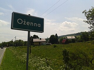
Ożenna is a village in the administrative district of Gmina Krempna, within Jasło County, Subcarpathian Voivodeship, in south-eastern Poland, close to the border with Slovakia. It lies approximately 11 kilometres (7 mi) south of Krempna, 36 km (22 mi) south of Jasło, and 78 km (48 mi) south-west of the regional capital Rzeszów.
Polany is a village in the administrative district of Gmina Krempna, within Jasło County, Subcarpathian Voivodeship, in south-eastern Poland, close to the border with Slovakia. It lies approximately 5 kilometres (3 mi) south-east of Krempna, 29 km (18 mi) south of Jasło, and 68 km (42 mi) south-west of the regional capital Rzeszów.
Rozstajne is a village in the administrative district of Gmina Krempna, within Jasło County, Subcarpathian Voivodeship, in south-eastern Poland, close to the border with Slovakia. It lies approximately 8 kilometres (5 mi) west of Krempna, 29 km (18 mi) south of Jasło, and 73 km (45 mi) south-west of the regional capital Rzeszów.
Świątkowa Mała is a village in the administrative district of Gmina Krempna, within Jasło County, Subcarpathian Voivodeship, in south-eastern Poland, close to the border with Slovakia. It lies approximately 13 kilometres (8 mi) west of Krempna, 28 km (17 mi) south of Jasło, and 75 km (47 mi) south-west of the regional capital Rzeszów.
Świątkowa Wielka is a village in the administrative district of Gmina Krempna, within Jasło County, Subcarpathian Voivodeship, in south-eastern Poland, close to the border with Slovakia. It lies approximately 7 kilometres (4 mi) west of Krempna, 24 km (15 mi) south of Jasło, and 70 km (43 mi) south-west of the regional capital Rzeszów.
Świerzowa Ruska is a village in the administrative district of Gmina Krempna, within Jasło County, Subcarpathian Voivodeship, in south-eastern Poland, close to the border with Slovakia. It lies approximately 8 kilometres (5 mi) north-west of Krempna, 23 km (14 mi) south of Jasło, and 68 km (42 mi) south-west of the regional capital Rzeszów.
Wyszowatka is a village in the administrative district of Gmina Krempna, within Jasło County, Podkarpackie Voivodeship, in south-eastern Poland, close to the border with Slovakia.
Żydowskie is a village in the administrative district of Gmina Krempna, within Jasło County, Subcarpathian Voivodeship, in south-eastern Poland, close to the border with Slovakia. It lies approximately 7 kilometres (4 mi) south-west of Krempna, 32 km (20 mi) south of Jasło, and 74 km (46 mi) south-west of the regional capital Rzeszów.


