Related Research Articles

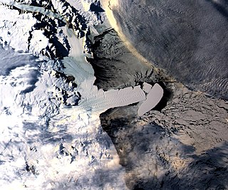
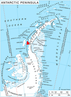
The Larsen Ice Shelf is a long ice shelf in the northwest part of the Weddell Sea, extending along the east coast of the Antarctic Peninsula from Cape Longing to Smith Peninsula. It is named after Captain Carl Anton Larsen, the master of the Norwegian whaling vessel Jason, who sailed along the ice front as far as 68°10' South during December 1893. In finer detail, the Larsen Ice Shelf is a series of shelves that occupy distinct embayments along the coast. From north to south, the segments are called Larsen A, Larsen B, and Larsen C by researchers who work in the area. Further south, Larsen D and the much smaller Larsen E, F and G are also named.
This is a list of extreme points in Antarctica.
The Drygalski Ice Tongue or Drygalski Barrier or Drygalski Glacier Tongue is a glacier in Antarctica, on the Scott Coast, in the northern McMurdo Sound of Antarctica's Ross Dependency, 240 kilometres (150 mi) north of Ross Island. The Drygalski Ice Tongue is stable by the standards of Antarctica's icefloes, and stretches 70 kilometres (43 mi) out to sea from the David Glacier, reaching the sea from a valley in the Prince Albert Mountains of Victoria Land. The Drygalski Ice Tongue ranges from 14 to 24 kilometres wide.

The Wordie Ice Shelf was a confluent glacier projecting as an ice shelf into the SE part of Marguerite Bay between Cape Berteaux and Mount Edgell, along the western coast of Antarctic Peninsula.

Marguerite Bay or Margaret Bay is an extensive bay on the west side of the Antarctic Peninsula, which is bounded on the north by Adelaide Island and on the south by Wordie Ice Shelf, George VI Sound and Alexander Island. The mainland coast on the Antarctic Peninsula is Fallières Coast. Islands within the bay include Pourquoi Pas Island, Horseshoe Island, Terminal Island, and Lagotellerie Island. Marguerite Bay was discovered in 1909 by the French Antarctic Expedition under Jean-Baptiste Charcot, who named the bay for his wife.

The Usarp Mountains are a major Antarctic mountain range, lying west of the Rennick Glacier and trending north to south for about 190 kilometres (118 mi). The feature is bounded to the north by Pryor Glacier and the Wilson Hills.

King Edward VII Land or King Edward VII Peninsula is a large, ice-covered peninsula which forms the northwestern extremity of Marie Byrd Land in Antarctica. The peninsula projects into the Ross Sea between Sulzberger Bay and the northeast corner of the Ross Ice Shelf, and forms part of the Ross Dependency. Edward VII Peninsula is defined by the Ross Ice Shelf on the southwest, Okuma Bay on the west, and to the east by Sulzberger Bay and the Saunders Coast, all essentially on the Ross Sea / Southern Ocean in Antarctica. The northwest extremity of the peninsula is Cape Colbeck. Edward VII Peninsula is located at 77°40′S155°00′W.
The Evans Ice Stream is a large ice stream draining from Ellsworth Land, between Cape Zumberge and Fowler Ice Rise, into the western part of the Ronne Ice Shelf. Mills Glacier flows adjacently into the ice stream from the southwest side. The feature was recorded on February 5, 1974, in Landsat imagery. It was named by the UK Antarctic Place-Names Committee for Stanley Evans, a British physicist who, starting in 1961, developed apparatus for radio echo sounding of icecaps and glaciers from aircraft; he carried out upper atmosphere research at Brunt Ice Shelf, 1956–57.

Totten Glacier is a large glacier draining a major portion of the East Antarctic Ice Sheet, through the Budd Coast of Wilkes Land in the Australian Antarctic Territory. The catchment drained by the glacier is estimated at 538,000 km2 (208,000 sq mi), extending approximately 1,100 km (680 mi) into the interior and holds the potential to raise sea level by at least 3.5 m (11 ft). Totten drains northeastward from the continental ice but turns northwestward at the coast where it terminates in a prominent tongue close east of Cape Waldron. It was first delineated from aerial photographs taken by USN Operation Highjump (1946–47), and named by Advisory Committee on Antarctic Names (US-ACAN) for George M. Totten, midshipman on USS Vincennes of the United States Exploring Expedition (1838–42), who assisted Lieutenant Charles Wilkes with correction of the survey data obtained by the expedition.
Shostakovich Peninsula is an ice-covered peninsula lying north of Stravinsky Inlet and extending into Bach Ice Shelf in southern Alexander Island, Antarctica. The peninsula was first mapped by Directorate of Overseas Surveys from satellite imagery of Antarctica supplied by U.S. National Aeronautics and Space Administration in cooperation with U.S. Geological Survey. Named by United Kingdom Antarctic Place-Names Committee after Dmitri Shostakovich, Russian composer (1906-1975). Shostakovich Peninsula is one of the eight peninsulas of Alexander Island.
Siemiatkowski Glacier is a glacier about 25 miles (40 km) long, flowing northwest to Nickerson Ice Shelf on the coast of Marie Byrd Land. Mapped from surveys by the United States Geological Survey (USGS) and U.S. Navy air photos (1959–65). Named by Advisory Committee on Antarctic Names (US-ACAN) for Edmond R. Siemiatkowski, auroral physicist at Byrd Station, 1964.
Zubchatyy Ice Shelf is a small ice shelf which borders the south side of Sakellari Peninsula in Enderby Land. Plotted by Russian cartographers from air photos taken by the Soviet Antarctic Expedition, 1961–62. The Russian name means "toothed" and refers to the serrated nature of the ice front when viewed in plan.

Il Polo Glacier is a small glacier draining northward between Polar Times Glacier and Polarforschung Glacier into the Publications Ice Shelf, Antarctica. It was delineated in 1952 by John H. Roscoe from air photos taken by U.S. Navy Operation Highjump, 1946–47, and was named by Roscoe for Il Polo, a polar journal published by the Istituto Geografico, Forlì, Italy.

The Arctic Ocean is the smallest and shallowest of the world's five major oceans. It spans an area of approximately 14,060,000 km2 (5,430,000 sq mi) and is known as the coldest of all the oceans. The International Hydrographic Organization (IHO) recognizes it as an ocean, although some oceanographers call it the Arctic Mediterranean Sea. It has been described approximately as an estuary of the Atlantic Ocean. It is also seen as the northernmost part of the all-encompassing World Ocean.
Antevs Glacier, also known as North Heim Glacier, is a glacier on Arrowsmith Peninsula, Graham Land, flowing north between Seue Peaks and Boyle Mountains into Muller Ice Shelf, Lallemand Fjord. It was named by the United Kingdom Antarctic Place-Names Committee in 1960 after Ernst V. Antevs, American glacial geologist.
Wyers Nunataks is a group of nunataks at the base of Sakellari Peninsula, just west of Wyers Ice Shelf in Enderby Land. Plotted from air photos taken from ANARE aircraft in 1956 and 1957. Named by Antarctic Names Committee of Australia (ANCA) for R.W.L. Wyers, glaciologist at Mawson Station in 1961.
Muller Ice Shelf, also known as Müller Ice Shelf according to the original German spelling of the family name Müller, was an ice shelf lying southwest of Hooke Point in southwest Lallemand Fjord, Arrowsmith Peninsula, Loubet Coast. It was nurtured by Brückner Glacier and Antevs Glacier.
Mount Pardoe is a mountain, 790 m, between Wyers Ice Shelf and Priestley Peak on the shore of Amundsen Bay in Enderby Land. It was plotted from air photos taken from ANARE aircraft in 1956 and was named by the Antarctic Names Committee of Australia (ANCA) for Dr. R. Pardoe, a medical officer at Mawson Station in 1961.
The Traverse Mountains of Antarctica are a group of almost ice-free mountains, rising to about 1,550 metres (5,090 ft), and including McHugo Peak, Mount Noel, Mount Allan and Mount Eissinger, between Eureka Glacier and Riley Glacier, east of Warren Ice Piedmont, in western Palmer Land. These mountains were first photographed from the air on November 23, 1935, by Lincoln Ellsworth and were mapped from these photographs by W.L.G. Joerg. They were first surveyed in 1936 by the British Graham Land Expedition (BGLE) under John Rymill and resurveyed in 1948 by the Falklands Islands Dependencies Survey. The name was first used by BGLE sledging parties because the mountains are an important landmark in the overland traverse from the Wordie Ice Shelf, down Eureka Glacier, to George VI Sound.
References
- ↑ "Wyers Ice Shelf, Antarctica". geographic.org. Open Publishing. Retrieved November 29, 2020.