
Kanal is a neighborhood in the city district of Trnje in Zagreb, Croatia. It is located northeast of the intersection of Vukovarska Avenue and Marin Držić Avenue and south of Radnička Road. The population is 1,411 (2011).

Maine Maritime Academy is a public college and nautical training institution in Castine, Maine. The academy was established by the 90th Maine Legislature on March 21, 1941. Unlike federal service academies, a congressional recommendation is not required to attend this state school. Students are not obligated to go to sea or into the military after graduation, and a large portion of the graduating class chooses shore-side employment, often in maritime related fields or the power generation industry.
Apongo District is one of twelve districts of the province Víctor Fajardo in Peru.
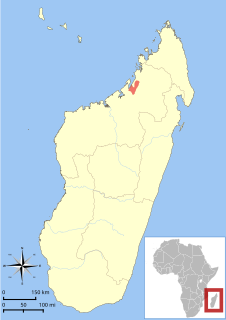
Danfoss' mouse lemur, or the Ambarijeby mouse lemur, is a species of mouse lemur endemic to Madagascar. It lives in western deciduous forest within a limited range between the Sofia River and the Maevarano River. It is a relatively large reddish mouse lemur with a total length of 25 to 29 centimeters, including 15 to 17 centimeters of tail.

Ramanantsoavana's woolly lemur, also known as Ramanantsoavana's avahi or the Manombo woolly lemur, is a species of woolly lemur native to southeastern Madagascar. It weighs about 1 kg. It was originally considered a subspecies of the southern woolly lemur, A. m. ramanantsoavana, but was elevated to a separate species in 2006 based on molecular, phenotypic and morphological data.
Zimny Zdrój is a village in the administrative district of Gmina Czernikowo, within Toruń County, Kuyavian-Pomeranian Voivodeship, in north-central Poland.
Nishi-Shikama Station is a train station in Himeji, Hyōgo Prefecture, Japan.
The Roman Catholic Diocese of Bettiah is a diocese located in the city of Bettiah in the Ecclesiastical province of Patna in India.
Siennica-Szymanki is a village in the administrative district of Gmina Czyżew-Osada, within Wysokie Mazowieckie County, Podlaskie Voivodeship, in north-eastern Poland.
Stawy is a village in the administrative district of Gmina Pogorzela, within Gostyń County, Greater Poland Voivodeship, in west-central Poland.

Tokiwadaira Station is a railway station operated by Shin-Keisei Electric Railway's Shin-Keisei Line located in Matsudo, Chiba Prefecture Japan. It is 5.6 kilometers from the terminus of the Shin-Keisei Line at Matsudo Station.
Radostowo is a settlement in the administrative district of Gmina Grzmiąca, within Szczecinek County, West Pomeranian Voivodeship, in north-western Poland.
Várvölgy is a village in Zala County, Hungary.
Donje Trebešinje is a village in the municipality of Vranje, Serbia. According to the 2002 census, the village has a population of 832 people.

The Bongolava mouse lemur is a species of mouse lemur endemic to Madagascar. It lives in western deciduous forest within a limited range, including Bongolava Forest and Ambodimahabibo Forest between the Sofia River and the Mahajamba River. It is a relatively large mouse lemur with a total length of 26 to 29 centimetres, including 15 to 17 centimeters of tail.
Yağlıpınar is a neighborhood of the District of Gölbaşı, Ankara Province, Turkey.
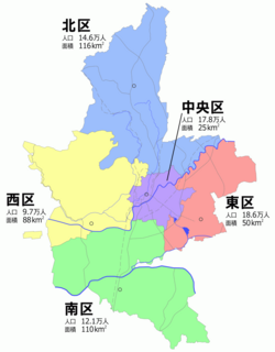
Chūō-ku (中央区) is one of the five wards of Kumamoto City, Japan. The ward is located in the center of the city.
Çağıllı is a village in the District of Demirözü, Bayburt Province, Turkey. As of 2010, it had a population of 9 people.

Uzmaston, Boulston and Slebech is a community in Pembrokeshire, Wales, featuring the villages of Uzmaston, Boulston and Slebech.

Henchir Bir Jedi is a town in Nabeul Governorate, Tunisia.


