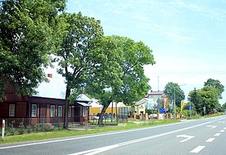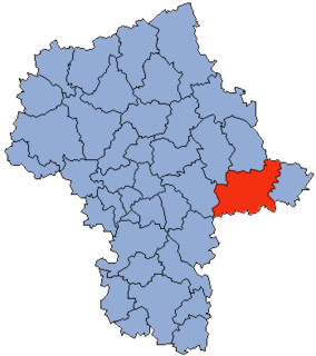
Przywory Duże is a village in the administrative district of Gmina Domanice, within Siedlce County, Masovian Voivodeship, in east-central Poland. It lies approximately 4 kilometres (2 mi) north-east of Domanice, 12 km (7 mi) south-west of Siedlce, and 84 km (52 mi) east of Warsaw.

Zażelazna is a village in the administrative district of Gmina Domanice, within Siedlce County, Masovian Voivodeship, in east-central Poland. It lies approximately 3 kilometres (2 mi) south-east of Domanice, 18 km (11 mi) south of Siedlce, and 85 km (53 mi) east of Warsaw.

Bojmie is a village in the administrative district of Gmina Kotuń, within Siedlce County, Masovian Voivodeship, in east-central Poland. It lies approximately 8 kilometres (5 mi) west of Kotuń, 22 km (14 mi) west of Siedlce, and 66 km (41 mi) east of Warsaw.

Broszków is a village in the administrative district of Gmina Kotuń, within Siedlce County, Masovian Voivodeship, in east-central Poland. It lies approximately 4 kilometres (2 mi) north-east of Kotuń, 12 km (7 mi) west of Siedlce, and 77 km (48 mi) east of Warsaw.

Sionna is a village in the administrative district of Gmina Kotuń, within Siedlce County, Masovian Voivodeship, in east-central Poland. It lies approximately 5 kilometres (3 mi) north-west of Kotuń, 18 km (11 mi) west of Siedlce, and 70 km (43 mi) east of Warsaw.

Żdżar is a village in the administrative district of Gmina Kotuń, within Siedlce County, Masovian Voivodeship, in east-central Poland. It lies approximately 9 kilometres (6 mi) west of Kotuń, 23 km (14 mi) west of Siedlce, and 65 km (40 mi) east of Warsaw.

Wyłazy is a village in the administrative district of Gmina Mokobody, within Siedlce County, Masovian Voivodeship, in east-central Poland. It lies approximately 7 kilometres (4 mi) north-west of Siedlce and 82 km (51 mi) east of Warsaw.

Kolonia Mordy is a village in the administrative district of Gmina Mordy, within Siedlce County, Masovian Voivodeship, in east-central Poland. It lies approximately 3 kilometres (2 mi) south-west of Mordy, 15 km (9 mi) east of Siedlce, and 102 km (63 mi) east of Warsaw.

Suchodół Wielki is a village in the administrative district of Gmina Mordy, within Siedlce County, Masovian Voivodeship, in east-central Poland. It lies approximately 8 kilometres (5 mi) east of Mordy, 24 km (15 mi) east of Siedlce, and 111 km (69 mi) east of Warsaw.

Głuchówek is a village in the administrative district of Gmina Przesmyki, within Siedlce County, Masovian Voivodeship, in east-central Poland. It lies approximately 6 kilometres (4 mi) south-west of Przesmyki, 20 km (12 mi) north-east of Siedlce, and 105 km (65 mi) east of Warsaw.

Kamianki-Czabaje is a village in the administrative district of Gmina Przesmyki, within Siedlce County, Masovian Voivodeship, in east-central Poland. It lies approximately 6 kilometres (4 mi) north of Przesmyki, 28 km (17 mi) north-east of Siedlce, and 110 km (68 mi) east of Warsaw.

Błogoszcz is a village in the administrative district of Gmina Siedlce, within Siedlce County, Masovian Voivodeship, in east-central Poland. It lies approximately 8 kilometres (5 mi) north-east of Siedlce and 94 km (58 mi) east of Warsaw.

Golice is a village in the administrative district of Gmina Siedlce, within Siedlce County, Masovian Voivodeship, in east-central Poland. It lies approximately 7 kilometres (4 mi) north-east of Siedlce and 93 km (58 mi) east of Warsaw.

Strzała is a village in the administrative district of Gmina Siedlce, within Siedlce County, Masovian Voivodeship, in east-central Poland.

Żytnia is a village in the administrative district of Gmina Siedlce, within Siedlce County, Masovian Voivodeship, in east-central Poland. It lies approximately 6 kilometres (4 mi) north-west of Siedlce and 84 km (52 mi) east of Warsaw.

Lipniak is a village in the administrative district of Gmina Wiśniew, within Siedlce County, Masovian Voivodeship, in east-central Poland. It lies approximately 7 kilometres (4 mi) west of Wiśniew, 11 km (7 mi) south-west of Siedlce, and 84 km (52 mi) east of Warsaw.

Cielemęc is a village in the administrative district of Gmina Zbuczyn, within Siedlce County, Masovian Voivodeship, in east-central Poland. It lies approximately 6 kilometres (4 mi) north of Zbuczyn, 11 km (7 mi) east of Siedlce, and 98 km (61 mi) east of Warsaw.

Grodzisk is a village in the administrative district of Gmina Zbuczyn, within Siedlce County, Masovian Voivodeship, in east-central Poland. It lies approximately 3 kilometres (2 mi) south-west of Zbuczyn, 15 km (9 mi) south-east of Siedlce, and 99 km (62 mi) east of Warsaw.

Tarcze is a village in the administrative district of Gmina Zbuczyn, within Siedlce County, Masovian Voivodeship, in east-central Poland. It lies approximately 6 kilometres (4 mi) north of Zbuczyn, 11 km (7 mi) east of Siedlce, and 98 km (61 mi) east of Warsaw.

Zdany is a village in the administrative district of Gmina Zbuczyn, within Siedlce County, Masovian Voivodeship, in east-central Poland. It lies approximately 3 kilometres (2 mi) north-west of Zbuczyn, 13 km (8 mi) south-east of Siedlce, and 98 km (61 mi) east of Warsaw.


