Osnabrück is a city in the German state of Lower Saxony. It is situated on the river Hase in a valley penned between the Wiehen Hills and the northern tip of the Teutoburg Forest. With a population of 168,145 Osnabrück is one of the four largest cities in Lower Saxony. The city is the centrepoint of the Osnabrück Land region as well as the District of Osnabrück.

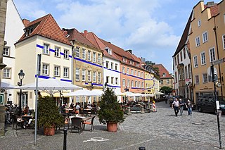
The Innenstadt is the central district of the city of Osnabrück in Lower Saxony, Germany; its population is roughly 8,300.
Widukindland is a district of Osnabrück, Germany. It is situated in the north-east of the city, on the slopes of the Schinkelberg. It arose from the former boundaries of Schinkel.
Schinkel is a district of Osnabrück, Germany, first mentioned in records in 1332. It is situated in the east of the city, into which it was incorporated on 1 April 1914. There are roughly 13,300 people in Schinkel.
Schinkel-Ost is a district of Osnabrück, Germany. It originally lay within the former boundaries of Schinkel, which was incorporated into Osnabrück in 1914. Schinkel-Ost is home to roughly 3,500 residents. The evangelical Jakobuskirche, Catholic Rosenkranzkirche, “Blau-Weiß” (blue-white) sports team, Diesterwegschule and the Gesamtschule Schinkel are located in this district.

Schölerberg is a district of Osnabrück, Germany, with approximately 13,900 residents.

Weststadt is a district of the city of Osnabrück with around 9,000 residents. It is located to the west of the Innenstadt district, on which it borders along with the districts of Westerberg, Wüste and Hellern.

Westerberg is a district of Osnabrück, Lower Saxony, Germany, with roughly 8,700 residents. It is situated in the west of the city between Lotter Straße and Pagenstecherstraße. The districts bordering it are Eversburg, Hafen, Sonnenhügel, Innenstadt, Weststadt, Hellern and Atter. The border with Atter passes through the Rubbenbruchsee, part of a large local recreation area.

Hafen (Harbour) is a district of Osnabrück, Lower Saxony. Germany. It is located in the north-west of the city and had a population of roughly 2,358 residents in 1,454 households as of late 2008. One year earlier the city had 2,372 residents. It covers an area of 407.2 hectares.

Hellern is a district of Osnabrück with roughly 6,800 residents, located on the western and south-western borders of the city. It is bordered by the Atter, Westernerg, Weststadt, Wüste and Sutthausen districts; on its west and south-west it borders on the municipality of Lotte in North Rhine-Westphalia and also Hasbergen in the surrounding district of Osnabrück. Hellern is located in the valley of the small Düte river.
Dodesheide is a town in the borough of Osnabrück, Germany; with a population of roughly 7,900 residents it is located to the north-east of the city. Its boundaries are delineated in the north by the Vehrter Landstraße, in the west by the landwehr – a former defensive line around the town consisting of a bank and ditches – in the south by the Sandbach and the Osnabrück-Bremen railway line; the city boundary itself marks its eastern border. It is made up of sections of the former districts of Schinkel and Haste.

Gartlage is a district of the city of Osnabrück, Lower Saxony, Germany. It is situated next to the Innenstadt.

Fledder is a district in the east of Osnabrück, Germany, characterised by its large prevalence of industrial estates. Despite being the location of numerous businesses and large supermarkets the district has comparatively few residential buildings; its population is roughly 2,400.

Kalkhügel is a district of Osnabrück, Germany with a population of roughly 5,900 residents. It is home to both a Protestant and a Catholic church. There is also a school centre (Schulzentrum) located in the district.
Haste is a district in the north-east of Osnabrück, Germany. It is the fifth-largest district in the city on the River Hase, with a total land area of 788.8 hectares. Currently it has a population of about 6,600.
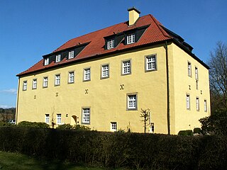
Sutthausen is a district of Osnabrück, Germany, with a population of about 4,500 residents. It is located in the south of the city, close to the Teutoburg Forest; it originally arose from two separate estates, Gut Sutthausen and Gut Wulften. The district has both Protestant and Catholic churches - respectively the Apostelkirche and the Marienkirche.

Atter is a district in the west of Osnabrück, Lower Saxony, Germany, with a population of 4,135 residents across 2,030 households. Covering an area of 1,075.9 hectares, it was incorporated into the city of Osnabrück on 1 July 1972. The districts on which it borders are Eversburg (NE), Westerberg (SE), and Hellern (S). On the west it borders on the municipality of Lotte in North Rhine-Westphalia; Autobahn 1 also passes through this area. The border with Westerberg runs through the Rubbenbruchsee, a local recreation area.
Voxtrup is a district in the south-east of Osnabrück, Germany, with a population of roughly 7,000 residents. It is home to the Evangelical Margaretenkirche and the Catholic St. Antonius Kirche.
Nahne is a district in the south of Osnabrück, Germany with a population of 2,241 residents, thus making it the city's smallest district in terms of population. It covers an area of 4.854 km2.

André Berghegger is a German politician of the Christian Democratic Union (CDU). From 2006 to 2013, he was mayor of the city of Melle.