
Sanag is an administrative region (gobol) in north eastern Somaliland. Sanaag has a long coastline facing the Gulf of Aden to the north, and is bordered by the region of Sahil to the west, Sool to the south and Somalia to the east. The region is disputed by the self-declared Republic of Somaliland and Puntland, a Federal Member State of Somalia. Its capital city is Erigavo. Sanaag is the largest region of Somaliland, accounting for 35% of Somaliland's total land area.
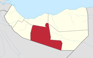
Togdheer is an administrative region (gobol) in central Somaliland. Togdheer is bordered by Maroodi Jeex to the west, Saaxil to the north, Sanaag to the northeast, Sool to the east and Ethiopia to the south. Its capital is Burao.

Marodi Jeh is an administrative region (gobol) in western Somaliland. It is the most populous region of the country. It is bordered by Awdal to the west, Sahil to the north, Togdheer to the east and Ethiopia to the south. Marodi Jeh was created by splitting the previously existing region (gobolka) In 2007 the region of Woqooyi Galbeed was renamed to Maroodi Jeex.
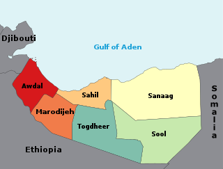
The regions of Somaliland is divided into six administrative regions, Awdal, Sahil, Maroodi-Jeeh, Togdheer, Sanaag and Sool. These are in turn subdivided into twenty-two districts. Regions of Somaliland are the primary geographical divisions through which Somaliland is administered. A distinction is made between districts of grades A, B, C and D, with the classification being based on population, area, economy and production.
Gugux is a town in the Sahil region of Somaliland.

The Districts of Somaliland are second-level administrative subdivisions of Somaliland, below the level of region. There are a total of 22 district, each district is rated A, B, C, or D according to population, budget, and economic scale with the highest being A grade. The district where the state capital is located is always Class A. The region with the most districts is Sanaag region (5), while the region with the fewest is Sahil region (2).

Sheikh District is a district in the Sahil region of Somaliland. Its capital lies at Sheikh. The district was part of Togdheer region until 1998, when the Sheikh District was incorporated into the Sahil region.

The administrative division of Somaliland are organized into three hierarchical levels. consists of 6 regions and 22 districts. Districts in turn contain villages. In addition, the capital Hargeisa has its own law that is different from the law that defines administrative divisions. The administrative-territorial division of the country is established by the Law of Somaliland No. 23/2002, which was finally approved in 2007.
Sahil is an administrative region (gobol) in northern Somaliland with the port city of Berbera as its capital. It was separated from Woqooyi Galbeed and became a province in 1991. In 1998, the Sheikh District of Togdheer was incorporated into Sahil region. The region has a long coastline facing the Gulf of Aden to the north. Sahil borders Awdal to the northwest, Maroodi Jeex to the southwest, Togdheer to the south and Sanaag to the east.

Ahmed Osman Hassan is a Somali politician, who is currently serving as the Governor of Sahil region of Somaliland since April 2018.
Beer is a village in Burao District, in the Togdheer region of Somaliland. It is located 30 kilometres (19 mi) south-east by road from Burao.
Jaamac Liibaan is a village in Burao District, in the Togdheer region of Somaliland.
War Idaad, also known as Wandad, Waridad, or Waridud is a town in Aynabo District, in the Sool region of Somaliland. In 2008, the surrounding villages were combined and promoted to "War Idaad District", and several more surrounding districts were combined to form the new "Saraar Region". In 2020, these became Aynabo District of the Sool Region.
Habariheshay is a village in the Aynabo District, in the Sool region of Somaliland.
Godheeli, also spelt God Heeli, is a town in the Aynabo District, in the Togdheer region of Somaliland.
Ceel Dhaab, also spelt Ceeldhaab is a town in the Aynabo District, in the Sool region of Somaliland.
Badweyn is a town in the Aynabo District, in the Sool region of Somalia.
Mandera is a town in the Maroodi Jeex province of Somaliland. Situated in the Hargeisa District, it is located northeast by road from Hargeisa and southwest of Berbera.
Kirit is a town in the Burao District, in the Togdheer region of Somaliland. The town is 92 km southeast of Burao, the regional capital. It located on the road connecting Burao and Las Anod. It belonged to the Saraar region, which was temporarily established in Somaliland.

