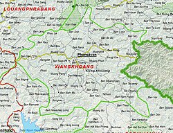
Xiangkhoang Plateau

Last updated
Xiang Khouang Plateau
ແຂວງຊຽງຂວາງ
Natural region
Plain of Jars - Laos - Countryside.JPG
Landscape of the Xiangkhouang Plateau
Map of Xiangkhoang Province, Laos.jpg
A map of the area showing the location of the provincial capital Phonsavan
Country Laos

The Xiang Khouang Plateau or Xiang Khwang Plateau, also known in French as Plateau du Tran-Ninh is a plateau in the north of Laos. The landscape is characterized by green mountains, rugged karst formations and verdant valleys with plenty of rivers, caves and waterfalls.

Contents

Geography

The Luang Prabang Range, and the Annamite Range separate the plateau from Thailand and Vietnam respectively. [1] The ranges of the plateau are sandstone and limestone mountains between 2000 and 2800 meters high (about 6561 and 9842 feet high). These have been heavily deforested. The highest mountain of Laos, Phou Bia, is located to the south of the Xiangkhoang. Altitudes within the plateau area may reach 1000 m. [2] Several tributaries of the Mekong drain in the plateau, such as the Nam Ngum, Ngiap and the Khan River. [3] The major town in the area is the capital of Phonsavan. The plateau gives its name to present-day Xiangkhouang Province in which Phonsavan is located.

History

The plateau is the location of the Plain of Jars, which is a collective name for several sites with funerary archeological remains nominated for UNESCO World Heritage status. [4] [5] Xianghouang Province is one of the most heavily bombed places in the world. [5]

The plateau is also one of the most heavily contaminated areas in the world from unexploded cluster munitions also called UXO.

Related Research Articles

<span class="mw-page-title-main">History of Laos</span> Aspect of Southeast Asian history

Evidence for modern human presence in the northern and central highlands of Indochina, that constitute the territories of the modern Laotian nation-state dates back to the Lower Paleolithic. These earliest human migrants are Australo-Melanesians—associated with the Hoabinhian culture—and have populated the highlands and the interior, less accessible regions of Laos and all of South-east Asia to this day. The subsequent Austroasiatic and Austronesian marine migration waves affected landlocked Laos only marginally and direct Chinese and Indian cultural contact had a greater impact on the country.

<span class="mw-page-title-main">Geography of Laos</span> Geographical features of Laos

Laos is an independent republic, and the only landlocked nation in Southeast Asia, northeast of Thailand, west of Vietnam. It covers 236,800 square kilometers in the center of the Southeast Asian peninsula and it is surrounded by Myanmar (Burma), Cambodia, the People's Republic of China, Thailand, and Vietnam. About seventy percent of its geographic area is made up of mountain ranges, highlands, plateaux, and rivers cut through.

<span class="mw-page-title-main">Muang Phuan</span>

Meuang Phuan or Xieng Khouang, also known historically to the Vietnamese as Trấn Ninh, was a historical principality on the Xiang Khouang Plateau, which constitutes the modern territory of Xiangkhouang Province, Laos.

<span class="mw-page-title-main">Plain of Jars</span> Megalithic archaeological landscape in Laos

The Plain of Jars is a megalithic archaeological landscape in Laos. It consists of thousands of stone jars scattered around the upland valleys and the lower foothills of the central plain of the Xiangkhoang Plateau. The jars are arranged in clusters ranging in number from one to several hundred.

<span class="mw-page-title-main">Phonsavan</span> District & municipality in Xiangkhouang Province, Laos

Phonsavan, population 37,507, is the capital of Xiangkhouang Province. Phonsavan was built in the late-1970s and replaced the old Xiangkhouang which was destroyed during the Second Indochina War.

<span class="mw-page-title-main">Annamite Range</span> 1,100 km long Mountain range in Indochina

The Annamite Range or the Annamese Mountains is a major mountain range of eastern Indochina, extending approximately 1,100 km (680 mi) through Laos, Vietnam, and a small area in northeast Cambodia. The mountain range is also referred to variously as Annamese Range, Annamese Mountains, Annamese Cordillera, Annamite Mountains and Annamite Cordillera. The name "Annam" is the Vietnamese pronunciation and terminology of Chinese: 安南, meaning "to pacify the south" referring to Vietnam. The French adopted the word and used "Annamese" or "Annamite" to refer to the Vietnamese.

<span class="mw-page-title-main">Lee Lue</span> Laotian Air Force officer (1935-1969)

Major Lee Lue was a Laotian Hmong fighter bomber pilot notable for flying more combat missions than any other pilot in the Kingdom of Laos. Lee Lue flew continuously, as many as 10 missions a day and averaging 120 combat missions a month to build a total of more than 5,000 sorties. Lee Lue was the leader of the special group of Hmong pilots flying T-28Ds from Long Tieng against the Pathet Lao and North Vietnamese positions. The group was funded by the CIA and was part of the regular Royal Lao Air Force, but took orders directly from MR2 Commander Gen. Vang Pao. His T-28 was shot down by anti-aircraft fire over Muang Soui, crashing in a mountainous area near Ban Phou Pheung Noi on July 12, 1969. At the time of his death, he had flown more combat missions than any other pilot in history.

<span class="mw-page-title-main">Phuan people</span> Thai ethnic group

The Phuan people, ພວນ Phouan, ), also known as Tai Phuan, Thai Puan or Lao Phuan, are a Theravada Buddhist Tai people spread out in small pockets over most of Thailand's Isan region with other groups scattered throughout central Thailand and Laos. There are also approximately 5000 Phuan in the Mongkol Borei District of Banteay Meanchey Province in Cambodia, as well in Battambang Province. According to the Ethnologue Report, the Phuan number 204,704 and that is split fairly evenly between populations in Laos and Thailand.

<span class="mw-page-title-main">Xieng Khouang Airport</span> Airport in Phonsavan, Laos

Xieng Khouang Airport is an airport in Phonsavan, Laos.

Khoune, formerly called Muang Khoun (Khoune) or Old Xiang Khouang is a district (muang) of Xiangkhouang province in north-central Laos. It is a ghost of its former self, 35 km southeast of Phonsavan, was once the royal seat of the minor kingdom of Muang Phuan, renowned in the sixteenth century for its 62 opulent stupas, whose sides were said to be covered in treasure. Years of bloody invasions by Thai and Vietnamese soldiers, pillaging by Chinese bandits in the nineteenth century and a monsoon of bombs that lasted nearly a decade during the Second Indochina War taxed this town so heavily that, by the time the air raids stopped, next to nothing was left of the kingdom's exquisite temples. The town is partly abandoned, and centuries of history were drawn to a close. All that remains of the kingdom's former glory is an elegant Buddha image towering over ruined columns of brick at Wat Phia Wat, and That Dam, both of which bear the scars of the events that ended Xieng Khuang's centuries of rich history. Although the town has been rebuilt and renamed, it has been supplanted by Phonsavan. In 1707, when the Kingdom of Lan Xang split into three separate kingdoms. Muang Phuan became a tributary state of the Kingdom of Luang Prabang.

<span class="mw-page-title-main">Muang Sing</span> District & municipality in Laos

Muang Sing is a small town and district (muang) in Luang Namtha Province, northwestern Laos, about 60 kilometres northwest of the town of Luang Namtha and 360 kilometres northwest of Vientiane. It lies very close to the border with Yunnan, China, surrounded by mountains and rivers. Historically, Muang Sing has been a major producer of opium and still has problems with drugs and smuggling, due to its proximity to China and Myanmar.

<span class="mw-page-title-main">Xiangkhouang</span> Province of Laos

Xiangkhouang is a province of Laos on the Xiangkhoang Plateau, in the nation's northeast. The province has the distinction of being the most heavily bombed place on Earth.

<span class="mw-page-title-main">Luang Prabang province</span> Province of Laos

Luang Prabang is a province in northern Laos. Its capital of the same name, Luang Prabang, was the capital of the Lan Xang Kingdom during the 13th to 16th centuries. It is listed since 1995 by UNESCO as a World Heritage Site for unique architectural, religious and cultural heritage, a blend of the rural and urban developments over several centuries, including the French colonial influences during the 19th and 20th centuries. The province has 12 districts. The Royal Palace, the national museum in the capital city, and the Phou Loei Protected Reserve are important sites. Notable temples in the province are the Wat Xieng Thong, Wat Wisunarat, Wat Sen, Wat Xieng Muan, and Wat Manorom. The Lao New Year is celebrated in April as The Bun Pi Mai.

Phou Xieng Thong National Protected Area is a national protected area in Salavan and Champasak provinces of southern Laos. This park, the country's only park on the Mekong river, is home to a wide variety of animal and plant species, some endangered. The park is an ecotourism destination.

<span class="mw-page-title-main">Muang Soui</span> Town in Laos

Muang Soui(In Lao: ເມືອງສຸຍ) is a small town in Xiangkhouang Province Laos. It is located on Route 7 of Laos, so east of Phoukhoune district, northwest of Phonsavan, and Ban Phou Pheung Noi, but north of Sam Thong, and Long Tieng.

<span class="mw-page-title-main">Đại Việt–Lan Xang War (1479–1484)</span>

The Đại Việt–Lan Xang War of 1479–84, also known as the White Elephant War, was a military conflict precipitated by the invasion of the Lao kingdom of Lan Xang by the Vietnamese Đại Việt Empire. The Vietnamese invasion was a continuation of Emperor Lê Thánh Tông's expansion, by which Đại Việt had conquered the kingdom of Champa in 1471. The conflict grew into a wider conflagration involving the Ai-Lao people from Sip Song Chau Tai along with the Mekong river valley Tai peoples from the Yuan kingdom of Lan Na, Lü kingdom Sip Song Pan Na, to Muang along the upper Irawaddy river. The conflict ultimately lasted approximately five years growing to threatened the southern border of Yunnan and raising the concerns of Ming China. Early gunpowder weapons played a major role in the conflict, enabling Đại Việt's aggression. Early success in the war allowed Đại Việt to capture the Lao capital of Luang Prabang and destroy the Muang Phuan city of Xiang Khouang. The war ended as a strategic victory for Lan Xang, as they were able to force the Vietnamese to withdraw with the assistance of Lan Na and Ming China. Ultimately the war contributed to closer political and economic ties between Lan Na, Lan Xang, and Ming China. In particular, Lan Na's political and economic expansion led to a "golden age" for that kingdom.

<span class="mw-page-title-main">Ban Phou Pheung Noi</span> Historic place in Laos

Ban Phou Pheung Noi is a Laotian village located at the peak of Phou Pheung mountain in the Xieng Khouang province of Laos. Phou Pheung mountain is approximately 916 m (3,005 ft). During the Vietnam War, combat between the American allies, the Hmong, and the Pathet Lao, The Laos Marxist government, and the Communist North Vietnamese People's Army took place on the mountain. Phou Pheung mountain runs from east to west and is rocky, and is covered in tropical forests. It is south of Muang Soui - Nongtang-Nato, and west of Phou Douk, Muang Phuan, Phonsavan and Plain of Jars. To the east, about 10 miles from Ban Phou Pheung Noi, is the Num Ngum 4 hydroelectric dam.

<span class="mw-page-title-main">Route 7 (Laos)</span> Route 7 of Laos


Route 7 of Laos, ເສັ້ນ ທາງ ເລກ 7 ຂອງປະເທດລາວ (ທ. 7) is a provincial road served from east to west in Xiangkhouang province, Laos. It runs from Nong Het in the east to Phoukhoune District in the west. This is where people change connections to go to Luang prabang or Vientiane.

<span class="mw-page-title-main">Depopulation of Muang Phuan</span>

The depopulation of Muang Phuan in 1834 was a forced migration campaign carried out by Siam in the course of their 1833–1834 war with Vietnam, in order to deny the Vietnamese the chance to re-establish control over the Xiangkhoang Plateau.

References

  1. The Ancient and Classical History of Southeast Asia
  2. Laos, Le « Pays du million d’éléphants »
  3. Encyclopædia Britannica - Xiangkhoang Plateau
  4. Welcome to Xieng Khouang! Archived December 20, 2011, at the Wayback Machine
  5. 1 2 Gilhooly, Rob (5 July 2000). "The Plain of Jars: A place of war and death". The Japan Times. Retrieved 16 May 2020.

Coordinates: 19°24′N103°02′E / 19.400°N 103.033°E / 19.400; 103.033