Local government in the Australian state of South Australia describes the organisations and processes by which towns and districts can manage their own affairs to the extent permitted by section 64A of Constitution Act 1934 (SA).

Adelaide Airport, also known as Adelaide International Airport, is the principal airport of Adelaide, South Australia and the fifth-busiest airport in Australia, servicing 8.5 million passengers in the financial year ending 30 June 2019. Located adjacent to West Beach, it is approximately 6 km (3.7 mi) west of the city centre. It has been operated privately by Adelaide Airport Limited under a long-term lease from the Commonwealth Government since 29 May 1998.

Eyre Highway is a 1,664-kilometre (1,034 mi) highway linking Western Australia and South Australia via the Nullarbor Plain. Signed as National Highways 1 and A1, it forms part of Highway 1 and the Australian National Highway network linking Perth and Adelaide. It was named after explorer Edward John Eyre, who was the first European to cross the Nullarbor by land, in 1840–1841. Eyre Highway runs from Norseman in Western Australia, past Eucla, to the state border. Continuing to the South Australian town of Ceduna, it then crosses the top of the Eyre Peninsula before reaching Port Augusta.

The Pitjantjatjara are an Aboriginal people of the Central Australian desert near Uluru. They are closely related to the Yankunytjatjara and Ngaanyatjarra and their languages are, to a large extent, mutually intelligible.
Anungu schools is a group of ten schools operated by the Government of South Australia which are located in the west of the Australian state of South Australia. Eight are located in the Aboriginal lands of Anangu Pitjantjatjara Yankunytjatjara, while one is in Maralinga Tjarutja and on in the community of Yalata, all offering primary and secondary schooling to a local body of students who are largely Aboriginal.
Oak Valley is the only community of Maralinga Tjarutja Aboriginal Council (AC) Local Government Area (LGA), South Australia. The population fluctuates, but a 2016 survey reported around 128 people, mostly Aboriginal. It is approximately 128 kilometres (80 mi) NNW of the original Maralinga township, and lies at the southern edge of the Great Victoria Desert. It is named for the desert oaks that populate the vicinity of the community.

Ooldea is a tiny settlement in South Australia. It is on the eastern edge of the Nullarbor Plain, 863 km (536 mi) west of Port Augusta on the Trans-Australian Railway. Ooldea is 143 km (89 mi) from the bitumen Eyre Highway.
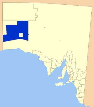
The Maralinga Tjarutja, or Maralinga Tjarutja Council, is the corporation representing the traditional Anangu owners of the remote western areas of South Australia known as the Maralinga Tjarutja lands. The council was established by the Maralinga Tjarutja Land Rights Act 1984. The area is one of the four regions of South Australia classified as an Aboriginal Council (AC) and not incorporated within a local government area.

Innamincka, formerly Hopetoun, is a township and locality in north-east South Australia with a population of 44 people as of the 2016 census. By air it is 820 kilometres north-east of the state capital, Adelaide, and 365 kilometres north-east of the closest town, Lyndhurst. It is 66 kilometres north-east of the Moomba Gas Refinery. The town lies within the Innamincka Regional Reserve and is surrounded by the Strzelecki Desert to the south and the Sturt Stony Desert to the north. It is linked by road to Lyndhurst via the Strzelecki Track, to the Birdsville Developmental Road via Cordillo Downs Road and Arrabury Road, and the Walkers Crossing Track to the Birdsville Track. The Walkers Crossing Track is closed in summer and only traversable in dry weather. The township is situated along the Cooper Creek, a part of the Lake Eyre basin.
Nullarbor Regional Reserve is a protected area in South Australia located about 300 kilometres west of Ceduna.
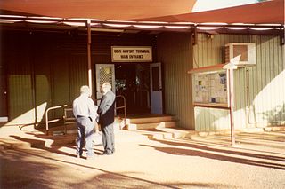
Gove Airport is on the Gove Peninsula in the Northern Territory of Australia. It services the mining town of Nhulunbuy and several Aboriginal communities including Yirrkala. The airport is located 5.8 nautical miles south southeast of the Nhulunbuy town centre, on Melville Road. It is operated by the Nhulunbuy Corporation.

Yalata is an Aboriginal community located 200 kilometres (120 mi) west of Ceduna and 140 km (87 mi) south of Ooldea on the edge of the Nullarbor Plain in South Australia. It lies on the traditional lands of the Wirangu people, but the settlement began as Yalata Mission in the early 1950s when Pila Nguru people were moved from Ooldea Mission when that closed, after previously being moved from their land in the Great Victoria Desert owing to nuclear testing by the British Government.
Fowlers Bay, formerly known as Yalata, is a bay, town and locality in the Australian state of South Australia located about 658 kilometres (409 mi) north-west of the state capital, Adelaide. The town is located on Port Eyre, at the western end of the larger Fowlers Bay. It was named Yalata after Yalata station, established in the 1860s and stretching from the Nullarbor Plain across to near Streaky Bay on the Eyre Peninsula, whose homestead was located on the hill nearby. The name Yalata now belongs to a small Aboriginal community further west, which was also situated on station land.

LauncherOne is a two-stage orbital launch vehicle developed and flown by Virgin Orbit that began operational flights in 2021, after being in development from 2007 to 2020. It is an air-launched rocket, designed to carry smallsat payloads of up to 300 kg (660 lb) into Sun-synchronous orbit (SSO), following air launch from a carrier aircraft at high altitude. The rocket is carried to the upper atmosphere on a modified Boeing 747-400, named Cosmic Girl, and released over ocean. Initial work on the program was done by Virgin Galactic, another Virgin Group subsidiary, before a separate entity — Virgin Orbit — was formed in 2017 to complete development and operate the launch service provider business separately from the passenger-carrying Virgin Galactic business.
Nullarbor Wilderness Protection Area is a protected area in the Australian state of South Australia located about 270 kilometres west of Ceduna in the locality of Nullarbor.
Yellabinna is a locality in the Australian state of South Australia located to the north of the town of Ceduna in the western part of the state.

The County of Hopetoun is one of the 49 counties of South Australia on the state's west coast. It was proclaimed in 1892 by Governor Algernon Keith-Falconer and named for John Hope then the Governor of Victoria.

The Yalata Indigenous Protected Area is an Indigenous Protected Area in South Australia. It has an area of 4643.97 km2.
