Related Research Articles
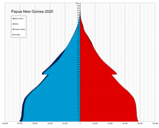
The indigenous population of Papua New Guinea is one of the most heterogeneous in the world. Papua New Guinea has several thousand separate communities, most with only a few hundred people. Divided by language, customs, and tradition, some of these communities have engaged in endemic warfare with their neighbors for centuries. It is the second most populous nation in Oceania, with a total population estimated variously as being between 9.5 and 10.1 million inhabitants.
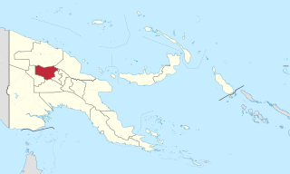
Enga is one of the provinces in Papua New Guinea (PNG). Enga is geographically situated in the northern region of Papua New Guinea and was separated from the adjacent Western Highlands at the time of national independence in 1975. The majority ethnic group are Engans. Approximately 500,000 people live within the province, which has one spoken language in all five of its districts. A small minority of Engans' land on the eastern side of the region remained in the Western Highlands, their territory being accessible by road from Mount Hagen but not directly from elsewhere in Enga territory.

The Gutnius Lutheran Church, formerly the Wabag Lutheran Church, is a Lutheran body existing in Papua New Guinea. Gutnius means "Good News" in Tok Pisin. It was established by the Lutheran Church–Missouri Synod in 1948, shortly after the Australian administration of the Territory of Papua and New Guinea permitted missionary activity to spread into the western highlands. The church counts 125.000 parishioners, largely confined to Enga Province in the western highlands. It operates Immanuel Lutheran Hospital and St. Paul's Lutheran Secondary School (Pausa) at Wapenamanda, Enga Province. The church has other health and educational institutions as well.
The Highlands Highway, sometimes known as the Okuk Highway, is the main land highway in Papua New Guinea. It connects several major cities and is vital for the movement of people and goods between the populous Highlands region and the coast.
Kyaka (Enga-Kyaka) is an Engan language of the East New Guinea Highlands in Enga Province, Papua New Guinea.
Kandep Rural LLG is one of two LLGs of the Kandep District of Enga Province, Papua New Guinea. It is located in southern Wabag, the capital town of Enga Province. Kandep shares land borders with Laiagam - Porgera, Wabag, and Wapenimanda District, along with additional land borders between the Southern Highlands, the Western Highlands provinces, and the newly Provinces.
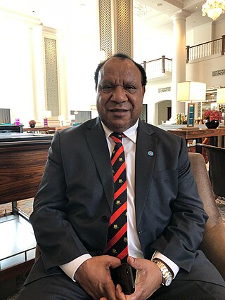
Rimbink Pato OBE is a Papua New Guinean constitutional lawyer and politician. He was Minister for Foreign Affairs and Trade from 2012 to 2019. Pato is the head of the United Party and its sole MP, representing Wapenamanda Open.
Enga Sign Language is an apparent village sign language among the Tato Enga people in Enga province, Papua New Guinea. It was reported in 1980 in three articles by Adam Kendon, based on ethnographic films of three signers in the upper valley of the Lagaip River, but with reports of wider use in the surrounding region. Its current status is unknown, as no more recent information is available.

The Papua New Guinea earthquake was a magnitude 7.5 earthquake that occurred in the Hela Province of Papua New Guinea on 26 February 2018, at 3:44 a.m. local time. The earthquake's epicenter was 10 kilometres (6.2 mi) west of the town of Komo. The maximum felt intensity was IX (Violent) on the Mercalli intensity scale. A total of 160 people were killed and many others were injured. An aftershock of M6.0 killed 11 people on 4 March, while another aftershock of M6.7 occurred at 00:13 local time on 7 March, killing at least 25 more. A 6.3 aftershock killed another 4 people on 7 April, more than a month after the first tremors hit the area.
Kompiam Rural LLG is a local-level government (LLG) of Enga Province, Papua New Guinea.
Ambum Rural LLG is a local-level government (LLG) of Enga Province, Papua New Guinea.
Lagaip Rural LLG is a local-level government (LLG) of Enga Province, Papua New Guinea.
Maip Muritaka Rural LLG is a local-level government of Enga Province, Papua New Guinea.
Wapenamanda Rural LLG is a local-level government (LLG) of Enga Province, Papua New Guinea.
Wabag Rural LLG is a local-level government (LLG) of Enga Province, Papua New Guinea.
Lumusa Rural LLG is a local-level government (LLG) of Western Highlands Province, Papua New Guinea.
Events in the year 2024 in Papua New Guinea.
From 18 March 2024 to 22 March 2024, floods and landslides in Papua New Guinea killed 23 people. The floods were caused by torrential rains and king tides.
On 24 May 2024, a landslide occurred in Mulitaka, Papua New Guinea. Over 2,000 people were thought to have been killed; however, only six bodies were recovered. Many others are missing, including about 2,500 in the villages of Kaokalam and Tulipana alone. It is the deadliest natural disaster in the country since the 1998 Papua New Guinea earthquake, and the deadliest landslide globally since the Vargas tragedy.
Kaokalam is a village in Enga Province, Papua New Guinea. It is located 600 kilometres northwest of the capital, Port Moresby.
References
- ↑ "Emergency convoy delivers provisions to survivors of devastating landslide in Papua New Guinea". Press Herald. 2024-05-25. Retrieved 2024-05-25.
- ↑ "The United Nations expresses its condolences to communities affected by the landslide in Yambali village, Enga Province". UNDP. Retrieved 2024-05-25.
| | This Enga Province geography article is a stub. You can help Wikipedia by expanding it. |