
Interstate 95 (I-95) is the main north–south Interstate Highway on the East Coast of the United States, running from U.S. Route 1 (US 1) in Miami, Florida, north to the Houlton–Woodstock Border Crossing between Maine and the Canadian province of New Brunswick. The highway largely parallels the Atlantic coast and US 1, except for the portion between Savannah, Georgia, and Washington, D.C., and the portion between Portland and Houlton in Maine, both of which follow a more direct inland route.

Fairfield County is a county in the southwestern corner of the U.S. state of Connecticut. It is the most populous county in the state and was also its fastest-growing from 2010 to 2020. As of the 2020 census, the county's population was 957,419, representing 26.6% of Connecticut's overall population. The closest to the center of the New York metropolitan area, the county contains four of the state's top 7 largest cities—Bridgeport (1st), Stamford (2nd), Norwalk (6th), and Danbury (7th)—whose combined population of 433,368 is nearly half the county's total population.

Interstate 89 (I-89) is an Interstate Highway in the New England region of the United States traveling from Bow, New Hampshire, to the Canada–United States border between Highgate Springs, Vermont, and Saint-Armand, Quebec. As with all odd-numbered primary Interstates, I-89 is signed as a north–south highway. However, it follows a primarily northwest-to-southeast path. The route forms a major part of the main connection between the cities of Montreal and Boston. In Quebec, the route continues as Route 133. The eventual completion of Autoroute 35 will lead to a nonstop limited-access highway route between Boston and Montreal, following I-93 south from I-89's terminus. The largest cities directly served by I-89 are Concord, the state capital of New Hampshire; Montpelier, the state capital of Vermont; and Burlington, Vermont. I-89 is one of three main Interstate highways whose route is located entirely within New England, along with I-91 and I-93.

Darien is a coastal town in Fairfield County, Connecticut, United States. With a population of 21,499 and a land area of just under 13 square miles (34 km2), it is the smallest town on Connecticut's Gold Coast. The town is part of the Western Connecticut Planning Region. It has a high rate of marriage, and high average number of children per household.

Norwalk is a city located in Western Connecticut, United States, in southern Fairfield County, on the northern shore of the Long Island Sound. Norwalk lies within both the New York metropolitan area and the Bridgeport metropolitan area.
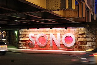
South Norwalk is a neighborhood in Norwalk, Connecticut which corresponds to the city's Second Taxing District. Often referred to as SoNo, the neighborhood was originally settled as Old Well, then chartered as the city of South Norwalk on August 18, 1870. The cities of Norwalk and South Norwalk were incorporated on June 6, 1913. South Norwalk underwent major redevelopment during the early 21st century, with many new apartments being constructed, often in close proximity to South Norwalk station, and generally more expensive than existing housing.

The Saugatuck River is a 23.7-mile-long (38.1 km) river in southwestern Connecticut in the United States. It drains part of suburban and rural Fairfield County west of Bridgeport, emptying into Long Island Sound.
The Connecticut Turnpike is a freeway and former toll road in the U.S. state of Connecticut; it is maintained by the Connecticut Department of Transportation (ConnDOT). Spanning approximately 128 miles (206 km) along a generally west–east axis, its roadbed is shared with Interstate 95 (I-95) for 88 miles (142 km) from the New York state border in Greenwich to East Lyme; I-395 for 36 miles (58 km) from East Lyme to Plainfield; and SR 695 for four miles (6.4 km) from Plainfield to the Rhode Island state line at U.S. Route 6 (US 6) in Killingly. The turnpike briefly runs concurrently with US 1 from Old Saybrook to Old Lyme and Route 2A from Montville to Norwich.

The Danbury Branch is a diesel branch of the Metro-North Railroad's New Haven Line in the U.S. state of Connecticut, running from downtown Norwalk north to Danbury. It opened in 1852 as the Danbury and Norwalk Railroad. Until the early 1970s, passenger service continued north from Danbury to Canaan, Connecticut, and Pittsfield, Massachusetts. Metro-North took over operation of the line from Conrail in 1983, and the modern-day branch is mostly single-tracked.

Cos Cob is a neighborhood and census-designated place in the town of Greenwich, Connecticut, United States. It is located on the Connecticut shoreline in southern Fairfield County. It had a population of 6,873 at the 2020 census.
Interstate 95 (I-95) is part of the Interstate Highway System and runs from Miami, Florida, to the Canada–United States border near Houlton, Maine. In the US state of New York, I-95 extends 23.50 miles (37.82 km) from the George Washington Bridge in New York City to the Connecticut state line at Port Chester. The George Washington Bridge carries I-95 across the Hudson River from New Jersey into New York City. There, I-95 runs across Upper Manhattan on the Trans-Manhattan Expressway for 0.81 miles (1.30 km) through Washington Heights. It continues east across the Harlem River on the Alexander Hamilton Bridge and onto the Cross Bronx Expressway. In the Bronx, I-95 leaves the Cross Bronx at the Bruckner Interchange, joining the Bruckner Expressway to its end. North of the interchange with Pelham Parkway, it then continues northeast via the New England Thruway out of New York City into Westchester County and to the Connecticut state line, where I-95 continues on the Connecticut Turnpike.
Interstate 95 (I-95) is the main north–south Interstate Highway on the East Coast of the United States, running in a general east–west compass direction for 111.57 miles (179.55 km) in Connecticut, from the New York state line to the Rhode Island state line. I-95 from Greenwich to East Lyme is part of the Connecticut Turnpike, during which it passes through the major cities of Stamford, Bridgeport, and New Haven. After leaving the turnpike in East Lyme, I-95 is known as the Jewish War Veterans Memorial Highway and passes through New London, Groton, and Mystic, before exiting the state through North Stonington at the Rhode Island border.

The history of Norwalk, Connecticut ranges from pre-contact cultures and Native Americans to the 21st century.

East Norwalk is a neighborhood of Norwalk, Connecticut, located mostly in Norwalk's third taxing district with segments of its northernmost area within the first and fifth taxing districts. As one of the earliest settlements of Norwalk, it was so marked with a block of 'suitably inscribed' 'native granite' formally located on the corner of Fitch Street and East Avenue.
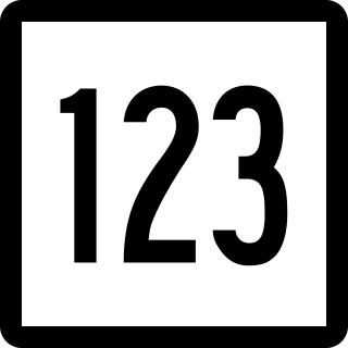
Route 123 is a secondary state highway in southwestern Connecticut from Norwalk to the New York state line near the town of Lewisboro.

U.S. Route 1 (US 1) in the U.S. state of Connecticut is a major east–west U.S. Route along Long Island Sound. It has been replaced by Interstate 95 (I-95) as a through route, which it closely parallels, and now primarily serves as a local business route. Despite its largely east–west orientation, it is part of a north–south route and is mostly signed north–south.
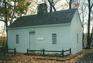
Mill Hill Historic Park in Norwalk, Connecticut, is a living history museum composed of three buildings: the circa 1740 Governor Thomas Fitch IV "law office", the c. 1826 Downtown District Schoolhouse, and the 1835 Norwalk Town Hall; as well as a historic cemetery also called the Town House Hill Cemetery. The museum is also known as the Mill Hill Historical Complex in some references and the sign at the parking lot reads Norwalk Mill Hill Museum.
Norwalk Harbor is a recreational and commercial harbor and seaport at the estuary of the Norwalk River where it flows into Long Island Sound in Norwalk, Connecticut, United States.

U.S. Route 7 (US 7) is a north–south United States Numbered Highway which runs 78 miles (126 km) in the state of Connecticut. The route begins at Interstate 95 (I-95) in Norwalk starting out as a four-lane freeway until the Wilton town line. The route then proceeds north as a two-lane surface road through Redding and Ridgefield, where it becomes a four-lane surface road until it reaches Danbury. The route becomes a four-lane freeway again, eventually merging with I-84 for a brief period before it turns and proceeds north with US 202 in Brookfield. The freeway section terminates at an intersection with US 202 at the Fairfield–Litchfield county line next to Candlewood lake. The route then continues north as a four-lane arterial road to New Milford, where it becomes a two-lane surface road, running north to the Massachusetts border in North Canaan. US 7 was aligned to its current route around 1930, and, since then, three sections totaling around 12 miles (19 km) have been upgraded to freeway standards.
Thomas Fitch V was a member of the Connecticut House of Representatives from Norwalk in the sessions of October 1761, May and October 1763, May and October 1764, May and October 1765, May and October 1766, May 1767, October 1768, May and October 1769, October 1770, October 1771, October 1772, October 1773, October 1775, and May 1776.
