Yarmouth Roads

Last updated

Yarmouth Roads
Haisboro Sands.jpg
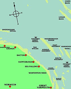
The map shows the position of cockle gateway the principal Northern Channel into Yarmouth Roads.
Location Southern North Sea, United Kingdom

Yarmouth Roads [1] is a coastal feature in Norfolk, England that was used by merchant and naval ships as an anchorage or roadstead [2] off Great Yarmouth.

Contents

Description

The following is a description of Yarmouth Roads that appeared in The Nautical Magazine and Naval Chronicle for 1837. [3]

There have always been considered two principle channels or gatways into Yarmouth roads - one at the northern extreme called the Cockle gatway, or between Cockle and Barber sands on the one side, and the Sea Heads and Scroby on the other side; and the other called St. Nicolas gatway, leading in from the S.E. between the Corton sand on the one side, and the Kettle Bottom on the other. This latter was always used by the north sea fleet, and is still preferred by the larger class of merchant-vessels, and some deep laden colliers, to a secondary channel existing at the southern extreme of the roads; and it is to this principal channel into Yarmouth roads, that I am anxious in this communication, to draw the attention of my fellow seamen frequenting the eastern coast, and which I shall endeavour to do by an introductory remark or two.
Other channels into the roads

There have been a number of other channels into yarmouth roads including: The St Nicholas Gat and the Hewett Channel. [4]

Royal Navy

The 28-gun frigate 'Surprize' lying in Yarmouth Roads, off Great Yarmouth in 1775 Francis Holman - The 28-gun frigate 'Surprize' lying in Yarmouth Roads.jpg
The 28-gun frigate 'Surprize' lying in Yarmouth Roads, off Great Yarmouth in 1775

Yarmouth Roads was one of a number of strategic East Coast anchorages [5] used by the Royal Navy for its fleets between the 13th and 19th centuries. [6] [7] Yarmouth was the headquarters of the English Navy's, Admiral of the North and his naval units from 1294 to 1412. Between 1652 and 1654 it was used by the Royal Navy for stationing its fleets during the First Anglo-Dutch War. [8] From 1781 to 1815 it was used as the base for the North Sea fleet. In 1801 it was the main assembly point for the British Fleet before its engagement at the Battle of Copenhagen. [9]

See also

Related Research Articles

<span class="mw-page-title-main">Great Yarmouth</span> Seaside Town in Norfolk, England

Great Yarmouth, often called Yarmouth, is a seaside town and unparished area in, and the main administrative centre of, the Borough of Great Yarmouth in Norfolk, England; it straddles the River Yare and is located 20 miles (30 km) east of Norwich. A population of 38,693 in the 2011 Census made it Norfolk's third most populous. Its fishing industry, mainly for herring, shrank after the mid-20th century and has all but ended. North Sea oil from the 1960s supplied an oil-rig industry that services offshore natural gas rigs; more recently, offshore wind power and other renewable energy industries have ensued.

<span class="mw-page-title-main">Battle of Copenhagen (1801)</span> Battle between British and Dano–Norwegian navies (1801)

The Battle of Copenhagen of 1801, also known as the First Battle of Copenhagen to distinguish it from the Second Battle of Copenhagen in 1807, was a naval battle in which a British fleet fought and defeated a smaller force of the Dano-Norwegian Navy anchored near Copenhagen on 2 April 1801. The battle came about over British fears that the powerful Danish fleet would ally with France, and a breakdown in diplomatic communications on both sides.

<span class="mw-page-title-main">The Downs (ship anchorage)</span> Roadstead near the English Channel

The Downs is a roadstead in the southern North Sea near the English Channel off the east Kent coast, between the North and the South Foreland in southern England. In 1639 the Battle of the Downs took place here, when the Dutch navy destroyed a Spanish fleet which had sought refuge in neutral English waters. From the Elizabethan era onwards, the presence of the Downs helped to make Deal one of the premier ports in England, and in the 19th century, it was equipped with its own telegraph and timeball tower to enable ships to set their marine chronometers.

HMS <i>Agamemnon</i> (1781) 1781 ship

HMS Agamemnon was a 64-gun third-rate ship of the line of the British Royal Navy. She saw service in the American Revolutionary War, French Revolutionary and Napoleonic Wars, and fought in many of the major naval battles of those conflicts. She is remembered as being Nelson's favourite ship, and was named after the mythical ancient Greek king Agamemnon, being the first ship of the Royal Navy to bear the name.

<span class="mw-page-title-main">Royal Navy Dockyard</span> State-owned shipbuilding and maintenance facilities for the British navy

Royal Navy Dockyards were state-owned harbour facilities where ships of the Royal Navy were built, based, repaired and refitted. Until the mid-19th century the Royal Dockyards were the largest industrial complexes in Britain.

HDMS <i>Holsteen</i>

Holsteen was a 60-gun ship of the line in the Royal Dano-Norwegian Navy. She was commissioned in 1775 and the British Royal Navy captured her in the Battle at Copenhagen Roads on 2 April 1801. The British renamed the ship HMS Holstein, and later HMS Nassau. She participated in one major battle during the Gunboat War and was sold in 1814.

<span class="mw-page-title-main">Nore</span> Sandbank at the mouth of the Thames Estuary

The Nore is a long bank of sand and silt running along the south-centre of the final narrowing of the Thames Estuary, England. Its south-west is the very narrow Nore Sand. Just short of the Nore's easternmost point where it fades into the channels it has a notable point once marked by a lightship on the line where the estuary of the Thames nominally becomes the North Sea. A lit buoy today stands on this often map-marked divisor: between Havengore Creek in east Essex and Warden Point on the Isle of Sheppey in Kent.

Lahaina Roads, also called the Lahaina Roadstead, is an anchorage in the ʻAuʻau Channel lying off the town of Lahaina on the island of Maui in the Hawaiian archipelago and U.S. state of Hawaii. It lies in the lee of the West Maui Mountains, with the surrounding islands of Lānaʻi adding to its general shelter from dangerous winds and large waves. It is most vulnerable to both from the south in the long open fetch between southern Maui and Kahoʻolawe, as during a "Kona storm" from that direction. While protected from the trade winds it is also subject to frequent heavy gusts and short sharp chop due to thermally induced gusts driven offshore from the West Mauis, and occasional wraparound from heavy winds in the Pailolo Channel between Maui and Molokai.

<span class="mw-page-title-main">Roadstead</span> Open anchorage affording some protection, but less than a harbor

A roadstead is a body of water sheltered from rip currents, spring tides, or ocean swell where ships can lie reasonably safely at anchor without dragging or snatching. It can be open or natural, usually estuary-based, or may be created artificially. In maritime law, it is described as a "known general station for ships, notoriously used as such, and distinguished by the name".

HMS <i>Gloucester</i> (1654) British frigate wrecked in 1682

The frigate Gloucester was a Speaker-class third rate, commissioned into the Royal Navy as HMS Gloucester after the restoration of the English monarchy in 1660. The ship was ordered in December 1652, built at Limehouse in East London, and launched in 1654. The warship was conveying James Stuart, Duke of York to Scotland, when on 6 May 1682 she struck a sandbank off the Norfolk coast, and quickly sank. The Duke was among those saved, but as many as 250 people drowned, including members of the royal party; it is thought that James's intransigence delayed the evacuation of the passengers and crew.

<span class="mw-page-title-main">Admiralty in the 17th century</span>

During the early 17th century, England's relative naval power deteriorated, In the course of the rest of the 17th century, The office of the Admiralty and Marine Affairs steered the Navy's transition from a semi-amateur Navy Royal fighting in conjunction with private vessels into a fully professional institution, a Royal Navy. Its financial provisions were gradually regularised, it came to rely on dedicated warships only, and it developed a professional officer corps with a defined career structure, superseding an earlier mix of sailors and socially prominent former soldiers.

<span class="mw-page-title-main">Admiralty in the 18th century</span>

The Glorious Revolution of 1688 rearranged the political map of Europe, and led to a series of wars with France that lasted well over a century. This was the classic age of sail; while the ships themselves evolved in only minor ways, technique and tactics were honed to a high degree, and the battles of the Napoleonic Wars entailed feats that would have been impossible for the fleets of the 17th century. Because of parliamentary opposition, James II fled the country. The landing of William III and the Glorious Revolution itself was a gigantic effort involving 100 warships and 400 transports carrying 11,000 infantry and 4,000 horses. It was not opposed by the English or Scottish fleets.

<span class="mw-page-title-main">Commander-in-Chief, North Sea</span>

The Commander-in-Chief, North Sea, was senior appointment and an operational command of the British Royal Navy originally based at Great Yarmouth from 1745 to 1802 then at Ramsgate from 1803 until 1815.

The 3rd and 4th Divisions was a naval formation of the Home Fleet, Royal Navy. It was created before the First World War from March 1909 until May 1912.

The Commander-in-Chief, English Channel or formally Commander-in-Chief, of His Majesty's Ships in the Channel was a senior commander of the Royal Navy. The Spithead Station was a name given to the units, establishments, and staff operating under the post from 1709 to 1746. Following Admiral Lord Anson new appointment as Commander-in-Chief, English Channel this office was amalgamated with the office of Commander-in-Chief, Portsmouth.

<span class="mw-page-title-main">North Sea Fleet (United Kingdom)</span> Military unit

The North Sea Fleet was a naval formation and major operational command of the British Royal Navy based at Great Yarmouth from 1745 to 1802 then at Ramsgate from 1803 until 1815.

<span class="mw-page-title-main">Baltic Fleet (United Kingdom)</span> Military unit

The British Baltic Fleet and also known as the Baltic Squadron was a series of temporary or semi permanent fleets of the Royal Navy. They were assembled at Spithead a naval anchorage in the English Channel for various naval operations in the Baltic Sea from 1658 to 1856 commanded by the Commander-in-Chief, Baltic Fleet.

<span class="mw-page-title-main">North Sea Squadron</span> Military unit

The North Sea Squadron was a temporary naval formation of the Tudor Navy Royal during the sixteenth century operating out of Newcastle, England.

Admiral Sir John Perbroun or John de Perbroun, was an English Knight, MP, merchant, ship owner and naval commander who served as Admiral of the North under King Edward III of England from (1322–1324) and again from.

HMS Cracker was an Acute-class gunbrig, launched in 1797. She was sold in 1802.

References

  1. "Yarmouth Roads, United Kingdom - Geographical Names, map, geographic coordinates". geographic.org. geographic.org, 1995-2012. Retrieved 9 October 2017.
  2. "Yarmouth Roads". www.mapcarta.com. Mapcarta. Retrieved 9 October 2017.
  3. The Nautical Magazine and Naval Chronicle for 1837. Cambridge University Press. 2013. p. 106. ISBN   9781108053891.
  4. Staff Reporter (11 February 2010). "Sandbanks retain a deep fascination". Great Yarmouth Mercury. Retrieved 9 October 2017.
  5. Davies, J. D. (2008). Pepys Navy: Ships, Men and Warfare 1649-89. Seaforth Publishing. p. 195. ISBN   9781783830220.
  6. Knight, Roger; Wilcox, Martin Howard (2010). Sustaining the Fleet, 1793-1815: War, the British Navy and the Contractor State. Boydell & Brewer. p. 192. ISBN   9781843835646.
  7. Coates, Liz (23 June 2016). "Former Great Yarmouth armoury honoured with blue plaque". Great Yarmouth Mercury. Retrieved 9 October 2017.
  8. Davies, J. D. (2008). Pepys Navy: Ships, Men and Warfare 1649-89. Seaforth Publishing. p. 195. ISBN   9781783830220.
  9. "THE BATTLE OF COPENHAGEN 2nd. April 1801 THE BRITISH FLEET" (PDF). www.nelson-society.com/. e Nelson Society. Retrieved 9 October 2017.

Coordinates: 52°35′N1°47′E / 52.583°N 1.783°E / 52.583; 1.783