
Cumberland County is a county in the State of New South Wales, Australia. Most of the Sydney metropolitan area is located within the County of Cumberland.

Bannaby is a locality in the Southern Tablelands of New South Wales, Australia in Upper Lachlan Shire. It is located near the township of Taralga, on the Bannaby road. At the 2016 census, it had a population of 36.

Darbalara is a rural community on the east bank of the junction of the Murrumbidgee River and Tumut River in the Riverina. It is situated by road, about 25 kilometres north east of Gundagai and 25 kilometres south of Coolac.

For lands administrative purposes, New South Wales is divided into 141 counties, which are further divided into parishes. The counties were first set down in the Colony of New South Wales, which later became the Australian state of New South Wales.

The Parish of Marulan is a parish of Argyle County located with the Goulburn Mulwaree local government area, which includes the towns of Marulan and Marulan South. The parish is bounded by Barbers Creek to the east, a small part of the Shoalhaven River to the south-east, and Jerrara Creek to the south. The Hume Highway and the Southern Highlands railway line run through the parish. Jerrara Road and Marulan South Road are other main roads in the area.

The Parish of Tarago is a parish of Argyle County. It does not actually contain the town of Tarago, which is located further to the south-east in the Parish of Mulwaree. The Parish was built by the Department of Lands in New South Wales.
The Parish of Wologorong is a parish of Argyle County, New South Wales, Australia.
The Parish of Nattery is a parish of Argyle County located between Goulburn and Marulan in New South Wales. It is just east of the village of Towrang and includes the locality of Carrick. The Wollondilly River is the boundary in the north-west. Jerraba creek is part of the boundary in the south-east. The Southern Highlands railway line runs through the northern end of the parish, to the east of the Wollondilly river. The Hume Highway passes through the middle of the parish.
The Parish of Currawang is a parish of Argyle County located to the north of Lake George. The parish was formerly known as the parish of Currowang, the former name discontinued on 14 November 1980 and the present name assigned.

The Bendoc River is a perennial river of the Snowy River catchment, located in the Alpine regions of the states of Victoria and New South Wales, Australia.
Nubba is a locality and former railway station on the Main South railway line in New South Wales, Australia, located midway between Wallendbeen and Harden. The station was open between 1882 and 1975 and has now been demolished. At the 2006 census, Nubba had a population of 281 people.
The Rocky Ponds Creek, a watercourse that is part of the Murrumbidgee catchment within the Murray–Darling basin, is located in the South West Slopes region of New South Wales, Australia.
Nanima is a locality in the Yass Valley Council area, New South Wales, Australia. It lies on the both sides of the Murrumbateman Road between Murrumbateman and Gundaroo, about 37 km north of Canberra. At the 2016 census, it had a population of 165.

Blowering, New South wales is a rural locality in the Snowy Mountains of New South wales and a civil Parish of Buccleuch County.
Goobarragandra, New South Wales is a rural locality in the Snowy Mountains west of Canberra, Australia.
Yarrangobilly, New South Wales is a rural locality in the Snowy Mountains, west of Canberra, Australia, and is also a civil Parish of Buccleuch County.
Burrendah, New South Wales is a bounded rural locality of Gilgandra Shire and a civil parish of Gowen County, a county of New South Wales.

Yarrawin, New South Wales is a bounded rural locality and a civil parish of Gowen County, New South Wales.
Neurea Parish, New South Wales is a civil parish of Gordon County, New South Wales, a Cadastral divisions of New South Wales.
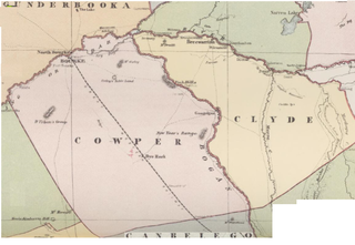
Maffra Parish, New South Wales is a Bounded locality of Bourke Shire and a civil Parish of Cowper County, New South Wales, a cadasteral division of central New South Wales.
