Yashma Tretiy

Last updated

Coordinates: 40°39′52″N49°31′32″E / 40.66444°N 49.52556°E / 40.66444; 49.52556

Geographic coordinate system Coordinate system

A geographic coordinate system is a coordinate system that enables every location on Earth to be specified by a set of numbers, letters or symbols. The coordinates are often chosen such that one of the numbers represents a vertical position and two or three of the numbers represent a horizontal position; alternatively, a geographic position may be expressed in a combined three-dimensional Cartesian vector. A common choice of coordinates is latitude, longitude and elevation. To specify a location on a plane requires a map projection.

Yashma Tretiy
Azerbaijan adm location map.svg
Red pog.svg
Yashma Tretiy
Coordinates: 40°39′52″N49°31′32″E / 40.66444°N 49.52556°E / 40.66444; 49.52556
CountryFlag of Azerbaijan.svg  Azerbaijan
Rayon Sumqayit
Time zone AZT (UTC+4)
  Summer (DST) AZT (UTC+5)

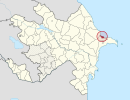
Yashma Tretiy is a village in Sumqayit, Azerbaijan.

Sumqayit City & Municipality in Azerbaijan

Sumqayit is the third-largest city in Azerbaijan, located near the Caspian Sea, about 31 kilometres away from the capital, Baku. The city has a population of around 298,000, making it the third-largest city in Azerbaijan after the capital Baku and Ganja. The city has a territory of 83 square kilometres (32 sq mi). It was founded on November 22, 1949. Two settlements are within the city administration: Jorat and Haji Zeynalabdin, a settlement named after oil businessman and philanthropist Haji Zeynalabdin Taghiyev. It is home to Sumqayit State University.

Azerbaijan Republic in Western Asia and Eastern Europe

Azerbaijan, officially the Republic of Azerbaijan, is a landlocked country in the South Caucasus region of Eurasia at the crossroads of Eastern Europe and Western Asia. It is bounded by the Caspian Sea to the east, Russia to the north, Georgia to the northwest, Armenia to the west and Iran to the south. The exclave of Nakhchivan is bound by Armenia to the north and east, Iran to the south and west, and has an 11 km long border with Turkey in the northwest.

Related Research Articles

Texass 12th congressional district

Texas District 12 in the United States House of Representatives is a Congressional district that serves the north portion of the state of Texas. As of 2017, the Twelfth District contained 806,551 people and had a median income of $67,703. It consists of the western half of Tarrant County, as well as all of Parker County and an eastern portion of Wise County. Fragments of the Dallas–Fort Worth metroplex are included in the district. As of 2018, Republican Kay Granger represents the district and has represented the district since her 1996 election.

Struve Geodetic Arc meridian arc

The Struve Geodetic Arc is a chain of survey triangulations stretching from Hammerfest in Norway to the Black Sea, through ten countries and over 2,820 km, which yielded the first accurate measurement of a meridian.

Oranienburger Tor (Berlin U-Bahn) Berlin U-Bahn station

Oranienburger Tor is a Berlin U-Bahn station located on the U 6. It is located 4.90 metres (16.1 ft) below the street.

Rural Municipality of Victoria rural municipality in Manitoba, Canada

The Rural Municipality of Victoria is located in south-central Manitoba, north-east of Glenboro. The RM was established in 1902 and named for Queen Victoria. In its westernmost part, the RM contains parts of Manitoba's Spruce Woods Provincial Forest and Spruce Woods Provincial Park.

Zagnańsk Village in Świętokrzyskie, Poland

Zagnańsk is a village in Kielce County, Świętokrzyskie Voivodeship, in south-central Poland. It is the seat of the gmina called Gmina Zagnańsk. It lies approximately 12 km (7 mi) north of the regional capital Kielce. The village has a population of 1,726.

Copper Mountain was an important copper-mining company town in the Similkameen Country of the Southern Interior of British Columbia, Canada, just south of the town of Princeton.

Nor Aresh Place in Yerevan, Armenia

Nor Aresh, is a neighbourhood in the Erebuni District of the Armenian capital Yerevan.

Michów, Lublin Voivodeship Village in Lublin, Poland

Michów is a village in Lubartów County, Lublin Voivodeship, in eastern Poland. It is the seat of the gmina called Gmina Michów. It lies approximately 21 kilometres (13 mi) west of Lubartów and 36 km (22 mi) north-west of the regional capital Lublin.

Ağalı, Agdash Place in Agdash, Azerbaijan

Ağalı is a village in the Agdash Rayon of Azerbaijan. The village forms part of the municipality of Yuxarı Zeynəddin.

Pashaly Treti Place in Hajigabul, Azerbaijan

Pashaly Treti is a village in the Hajigabul Rayon of Azerbaijan.

Üçüncü Beynəlmiləl Place in Shamkir, Azerbaijan

Üçüncü Beynəlmiləl is a village in the Shamkir Rayon of Azerbaijan.

Yaşma Place in Khizi, Azerbaijan

Yaşma is a village in the Khizi Rayon of Azerbaijan. The village forms part of the municipality of Şuraabad.

Ağqıraq Place in Yevlakh, Azerbaijan

Ağqıraq is a village in the Yevlakh Rayon of Azerbaijan. The village forms part of the municipality of Balçılı.

Světice is a village and municipality in Prague-East District in the Central Bohemian Region of the Czech Republic.

Meedla is a village in Saaremaa Parish, Saare County in western Estonia.

Zenobuurt is a neighborhood of Rotterdam, Netherlands.

Maimarktgelände

The Maimarktgelände is an exhibition site located in Mannheim, Germany, which covers a surface of 210,000 m². It hosts the annual Mannheim May Market as well as open-air concerts and other events. Starting in February each year, 47 exhibition halls with a surface of 42,000 m² are developed on the apron of the site. With approximately 1,500 exhibitors and around 400,000 visitors annually, the Maimarktgelände is a major German regional exhibition.

Gushikawa Castle (Itoman) castel in Okinawa, Jpan

Gushikawa Castle is a Ryukyuan gusuku in Itoman, Okinawa.

Steam Corners is an unincorporated community in Morrow County, in the U.S. state of Ohio.

Cessna is a populated place in Bedford County, Pennsylvania, United States, located within Bedford Township. Its elevation is at 1,102 feet above sea level.

References