This page is based on this
Wikipedia article Text is available under the
CC BY-SA 4.0 license; additional terms may apply.
Images, videos and audio are available under their respective licenses.

Vest-Agder [²vɛstˌɑɡdər] (listen) (West Agder) is a county in Norway, bordering Rogaland to the West and Aust-Agder to the East. In 2016, there were 182,701 inhabitants, which is about 3.5% of the total population of Norway. Its area is about 7,277 square kilometres (2,810 sq mi). The county administration is located in its largest city, Kristiansand.
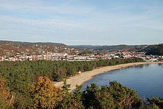
Mandal (help·info) is a municipality in Vest-Agder county, Norway. It is located in the traditional district of Sørlandet. Mandal is the southernmost municipality in all of Norway, with the tiny skerry of Pysen being the southernmost point of land in Norway.

Girgaon, also spelt formerly Girgaum, is an area in southern Mumbai in Maharashtra, India. Charni Road rastation is situated in Girgaon. The culture in Girgaon is diverse and varied. Like most areas of cosmopolitan Mumbai, residents span diverse languages, religions, traditions, festivals, and attire. Girgaon occupies prime residential real estate due to increasing demand just because of its prominent location in South Mumbai. The Sanskrit term "Giri" stands for hills, whereas the Sanskrit word "gram" denotes a village. Thus, Girgaon means a village at the foothill of mountains. A birds' eye view from the top of Malabar Hill will justify this etymological finding.

YSR Kadapa district is said to be the heart of the Rayalaseema as it is centrally located and well connected with the 4 districts of Rayalaseema. The District has a glorious history and a rich cultural heritage.
Kadapa district is one of the 13 districts in the Indian state of Andhra Pradesh. It is also one of the four districts in the Rayalaseema region of the state. The city of Kadapa is the seat of administration for the district.
Mandals, taluka panchayats, block panchayats, or panchayat samiti are rural local governments (panchayats) at the intermediate level in panchayat raj institutions (PRI).

Bheemunipatnam popularly known by its abbreviated form Bheemili, is a neighbourhood in the city of Visakhapatnam, India. The town was named after Bhima a character in the Hindu epic Mahabharata. Bheemunipatnam municipality was merged into Greater Visakhapatnam Municipal Corporation

Lingala is a village in the Khammam district, in the state of Telangana, India. It is located 6 km from its local Mandal at Kalluru
Sadasivanagar is a village and a Mandal in Nizamabad district in the state of Telangana in India.

Vadamalapeta is a mandal headquarters in Chittoor district of the Indian state of Andhra Pradesh. Padiredu, Tirumandyam and Berivani Kandriga are some of the villages of Vadamalapet mandal.Kiran Kumar Kalluru is one of the Famous Film Distributor from this Place.
Yellanur is a village in Anantapur district of the Indian state of Andhra Pradesh. It is the mandal headquarters of Yellanur mandal in Anantapur revenue division. It is located 51.8 km distance from its district main city Anantapur and 420 km distance from state's capital Amaravati.
Pullaiah banzar is a village located in Kalluru Mandal, Khammam district in Telangana. This village has nearly 400 homes and 1500 peoples.
Kappalabandham is a village in the Khammam district, in the state of Telangana, India. It is located 3 km from its local Mandal at Kalluru.
Pullaiah or Pullayya is an Indian name.

Lakkoju Sanjeevaraya Sharma was an Indian mathematician from Andhra Pradesh. He was born blind and gave many Mathematical Avadhanams (Ganitavadhanams) and surprised the elite and educated people.
Chennuru is a village in Kalluru Mandal in Khammam District of Telangana State.
Chennuru is a large village located in Kallur Mandal of Khammam district, Telangana with total 1004 families residing. The Chennuru village has population of 3416 of which 1693 are males while 1723 are females as per Population Census 2011.
In Chennuru village population of children with age 0-6 is 337 which makes up 9.87 % of total population of village. Average Sex Ratio of Chennuru village is 1018 which is higher than Andhra Pradesh state average of 993. Child Sex Ratio for the Chennuru as per census is 994, higher than Andhra Pradesh average of 939.
Payapur is a village in the Khammam district, in the state of Andhra Pradesh, India. It is located 3 km from its local Mandal at Kalluru.
Pulicherla mandal is one of the 66 mandals in Chittoor district of the Indian state of Andhra Pradesh. The mandal headquarters are located at Reddivaripalle. The mandal is bounded by Chinnagottigallu, Chandragiri, Rompicherla, Pakala, Pileru, Sodam and Irala mandals.Pulichelra located between Kalluru and Rompicherla road. It has a Railwaystation and the code PCL.Only passenger Trains will be halted.
Currently there are only Four passenger stops. Two at day time and remains at Night. There were multiple express trains but no halt.
The train root connects Dharmavaram and Tirupati.

Mahabubabad is a district in the Indian state of Telangana. It was a part of the Warangal district prior to the re-organisation of districts in the state in October 2016.The district shares boundaries with Suryapet, Khammam, Bhadradri Kothagudem,Jayashankar Bhupalpalle,Warangal Rural, Jangaon districts.
National Highway 365BB is a national highway in India. It is a secondary route of National Highway 65. NH-365BB traverses the states of Andhra Pradesh and Telangana in India.


