Related Research Articles

The Town of Crestone is a Statutory Town in Saguache County, Colorado. According to the 2020 United States Census, the town's population was 141. Crestone is located at the foot of the western slope of the Sangre de Cristo Range, in the northern part of the San Luis Valley. Crestone was platted in 1880 by George Adams, owner of the neighboring Luis Maria Baca Grant No. 4. In the 1970s, the Baca Grande land development was established on the lands of the Baca Grant to the south and west. Several hundred homes have been built there.
Yeso may refer to:
Baca County is a county located in the U.S. state of Colorado. As of the 2020 census, the population was 3,506. The county seat is Springfield. Located at the southeast corner of Colorado, the county shares state borders with Kansas, New Mexico, and Oklahoma.

Fort Sumner is a village in and the county seat of De Baca County, New Mexico, United States. The population was 1,031 at the 2010 U.S. Census, down from the figure of 1,249 recorded in 2000. Fort Sumner is the spring and fall home of the Columbia Scientific Balloon Facility.
Baca may refer to:

The Chunky River is a short tributary of the Chickasawhay River in east-central Mississippi. Via the Chickasawhay, it is part of the watershed of the Pascagoula River, which flows into the Gulf of Mexico.

The Noxubee River (NAHKS-uh-bee) is a tributary of the Tombigbee River, about 90.6 miles (145.8 km) long, in east-central Mississippi and west-central Alabama in the United States. Via the Tombigbee, it is part of the watershed of the Mobile River, which flows to the Gulf of Mexico.
The Yockanookany River is a 78.4-mile-long (126.2 km) river in central Mississippi in the United States. It is a tributary of the Pearl River, which flows to the Gulf of Mexico.
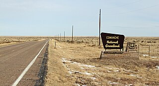
Comanche National Grassland is a National Grassland located in southeastern Colorado, United States. It is the sister grassland of Cimarron National Grassland and contains both prairie grasslands and canyons. It is separated into two sections, each operated by a local ranger district, one of which is in Springfield and the other of which is in La Junta. The grassland is administered by the Forest Service together with the Pike and San Isabel National Forests, and the Cimarron National Grassland, from common headquarters located in Pueblo, Colorado.

Jimmy Santiago Baca is an American poet, memoirist, and screenwriter from New Mexico.

U.S. Route 60 (US 60) is an east–west United States Highway within New Mexico. It begins at the Arizona state line and continues east to the Texas state line.

Ezequiel Cabeza De Baca was the first Hispano elected for office as lieutenant governor in New Mexico's first election. His term as lieutenant governor was followed by his election as the second elected governor of New Mexico. This term was brief as he died shortly after taking office. He was the state's first elected Hispanic governor, and the first governor born in New Mexico after its annexation by the United States.
Yeso is an unincorporated desert village in De Baca County, New Mexico, United States, located along U.S. Route 60 west of Fort Sumner. The post office serving zip code 88136 is the only business or service in Yeso; there are also perhaps a half dozen houses.

De Baca County is a county in the U.S. state of New Mexico. As of the 2020 census, the population was 1,698, making it New Mexico's second-least populous county. Its county seat is Fort Sumner. The county is named for Ezequiel Cabeza De Baca, the second elected Governor of New Mexico.

The Abo Formation is a geologic formation in New Mexico. It contains fossils characteristic of the Cisuralian epoch of the Permian period.

The Yeso Group is a group of geologic formations in New Mexico. It contains fossils characteristic of the Kungurian Age of the early Permian Period.
Hispanic and Latino Coloradans are residents of the state of Colorado who are of Hispanic or Latino ancestry. As of 2020, Hispanics and Latinos of any race made up 21% of the state's population, or 1,269,520 of the state's 5,770,545 residents.
Carrizo Creek and Carrizo Wash may refer to various streams or washes (arroyos) named Carrizo, the Spanish word for "reeds". Streams and washes of this name include:
North Carrizo Creek forms in Baca County, Colorado at the confluence of East Carrizo Creek and West Carrizo Creek, at a point about 6 miles north of the Preston Monument, the tripoint of Colorado, Oklahoma and New Mexico. North Carrizo Creek then flows generally south-southeast into Oklahoma to join the Cimarron River northeast of Kenton, Oklahoma.
References
- ↑ U.S. Geological Survey Geographic Names Information System: Yeso Creek
- ↑ "Yeso Founded In 1906 During Drought". De Baca County News. Jan 5, 1978. p. 2. Retrieved 18 May 2015.